File:Stadtplan Solothurn, Baedeker 1913.jpg
Jump to navigation
Jump to search

Size of this preview: 800 × 546 pixels. Other resolutions: 320 × 218 pixels | 640 × 437 pixels | 1,024 × 699 pixels | 1,280 × 873 pixels | 2,560 × 1,747 pixels | 3,488 × 2,380 pixels.
Original file (3,488 × 2,380 pixels, file size: 2.7 MB, MIME type: image/jpeg)
Captions
Captions
Add a one-line explanation of what this file represents
Summary
[edit]
| Description |
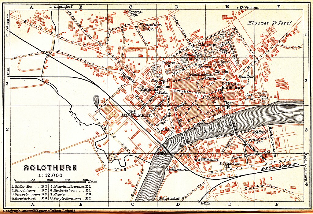
English: Map of Solothurn, probably around 1902 to 1905
Deutsch: Stadtplan von Solothurn. Das Erstellungsdatum ist unklar. Der Plan stammt aus einem Reiseführer von 1913, zeigt aber die 1905 abgebrochene Turnschanze sowie die 1902 eröffeten Einrichtungen Kunstmuseum und Konzertsaal; eine Erstellung zwischen 1902 und 1905 ist daher wahrscheinlich. |
| Date | <= 1913 |
| Source | Karl Bædeker: Die Schweiz nebst angrenzenden Teilen von Oberitalien, Savoyen und Tirol - Handbuch für Reisende, 35. Auflage, Verlag von Karl Bædeker, Leipzig 1913 |
| Author | Unknown author |
Licensing
[edit]
This image (or other media file) is in the public domain because its copyright has expired and its author is anonymous.
This applies to the European Union and those countries with a copyright term of 70 years after the work was made available to the public and the author never disclosed their identity. Important: Always mention where the image comes from, as far as possible, and make sure the author never claimed authorship. Note: In Germany and possibly other countries, certain anonymous works published before July 1, 1995 are copyrighted until 70 years after the death of the author. See Übergangsrecht. Please use this template only if the author never claimed authorship or their authorship never became public in any other way. If the work is anonymous or pseudonymous (e.g., published only under a corporate or organization's name), use this template for images published more than 70 years ago.
For a work made available to the public in the United Kingdom, please use Template:PD-UK-unknown instead.
|
File history
Click on a date/time to view the file as it appeared at that time.
| Date/Time | Thumbnail | Dimensions | User | Comment | |
|---|---|---|---|---|---|
| current | 22:49, 31 May 2010 | | 3,488 × 2,380 (2.7 MB) | H005 (talk | contribs) | {{Information |Description={{en|1=Map of Solothurn, 1913 or earlier}} {{de|1=Stadtplan von Solothurn, 1913 oder früher}} |Source=Karl Bædecker: ''Die Schweiz nebst angrenzenden Teilen von Oberitalien, Savoyen und Tiro |
You cannot overwrite this file.
File usage on Commons
The following page uses this file:
- File:StadtplanSolothurnBaedecker1913.jpg (file redirect)
File usage on other wikis
The following other wikis use this file: