File:Stadtviertel und Quartiere der Altstadt von Bern.jpg
Jump to navigation
Jump to search
Size of this preview: 800 × 367 pixels. Other resolutions: 320 × 147 pixels | 640 × 294 pixels | 1,024 × 470 pixels | 1,280 × 588 pixels | 2,763 × 1,269 pixels.
Original file (2,763 × 1,269 pixels, file size: 2.04 MB, MIME type: image/jpeg)
Captions
Captions
Add a one-line explanation of what this file represents
Summary[edit]
| Description |
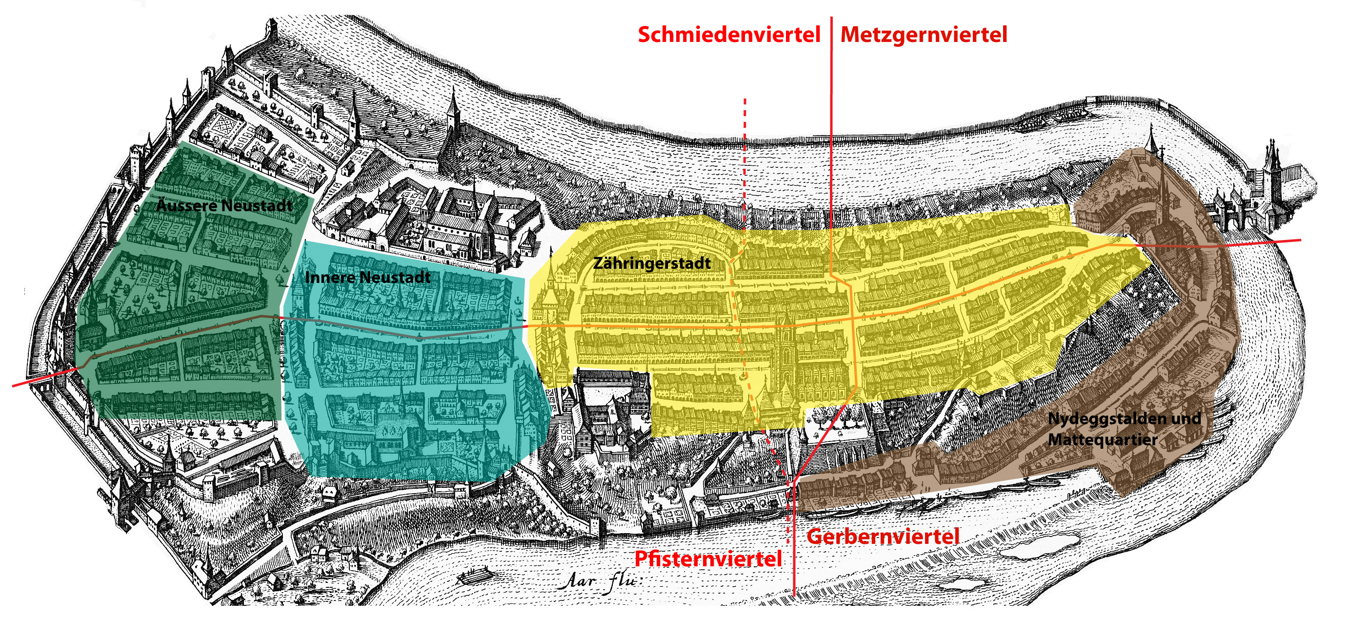
Deutsch: Historische Stadtviertel und Quartiere der Altstadt von Bern. Die punktierte Linie stellt die vom 16. bis zum 18. Jahrhundert geltende neue Viertelgrenze dar. English: Historical districts ("Viertel") and neighbourhoods ("Quartiere") of the old town of Berne. The dotted line represents the new district boundary of the 16th to 18th century. |
| Source | Self-made based on Image:MerianBern.jpg and on a map by Roland Gerber in: Ellen J. Beer et al. (eds.), Berns grosse Zeit, ISBN 3-906721-28-0, p. 43. |
| Author | Sandstein |
Licensing[edit]
| I, the copyright holder of this work, release this work into the public domain. This applies worldwide. In some countries this may not be legally possible; if so: I grant anyone the right to use this work for any purpose, without any conditions, unless such conditions are required by law. |
File history
Click on a date/time to view the file as it appeared at that time.
| Date/Time | Thumbnail | Dimensions | User | Comment | |
|---|---|---|---|---|---|
| current | 16:16, 4 January 2008 | | 2,763 × 1,269 (2.04 MB) | Sandstein (talk | contribs) | {{Information |Description={{de|Historische Stadtviertel und Quartiere der Altstadt von Bern. Die punktierte Linie stellt die vom 16. bis zum 18. Jahrhundert geltende neue Viertelgrenze dar.}}{{en|Historical quarters ("Viertel") and districts ("Quartiere" |
You cannot overwrite this file.
File usage on Commons
The following 2 pages use this file:
File usage on other wikis
The following other wikis use this file:
- Usage on ar.wikipedia.org
- Usage on de.wikipedia.org
- Usage on en.wikipedia.org
- Usage on sl.wikipedia.org
- Usage on zh.wikipedia.org