File:Stations REM.png
Jump to navigation
Jump to search

Size of this preview: 800 × 318 pixels. Other resolutions: 320 × 127 pixels | 640 × 254 pixels | 1,024 × 407 pixels | 2,189 × 870 pixels.
Original file (2,189 × 870 pixels, file size: 348 KB, MIME type: image/png)
Captions
Captions
Add a one-line explanation of what this file represents
Summary[edit]
| Description |
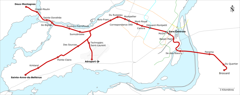
Français : Carte géographiquement exacte du réseau express métropolitain proposé. |
| Date | |
| Source | Own work |
| Author | Calvin411 |
Licensing[edit]
I, the copyright holder of this work, hereby publish it under the following license:
This file is licensed under the Creative Commons Attribution-Share Alike 4.0 International license.
- You are free:
- to share – to copy, distribute and transmit the work
- to remix – to adapt the work
- Under the following conditions:
- attribution – You must give appropriate credit, provide a link to the license, and indicate if changes were made. You may do so in any reasonable manner, but not in any way that suggests the licensor endorses you or your use.
- share alike – If you remix, transform, or build upon the material, you must distribute your contributions under the same or compatible license as the original.
File history
Click on a date/time to view the file as it appeared at that time.
| Date/Time | Thumbnail | Dimensions | User | Comment | |
|---|---|---|---|---|---|
| current | 01:23, 2 August 2023 | 2,189 × 870 (348 KB) | Jeangagnon (talk | contribs) | Changement de Rive-Sud pour Brossard | |
| 03:05, 26 April 2018 | 2,189 × 870 (336 KB) | Calvin411 (talk | contribs) | Network Updates | ||
| 21:14, 25 November 2016 | 2,189 × 870 (341 KB) | Calvin411 (talk | contribs) | New stations planned according to the most recent information. | ||
| 17:10, 26 September 2016 | 2,189 × 870 (350 KB) | Calvin411 (talk | contribs) | Correction of Autoroute 13 station position. | ||
| 19:37, 12 September 2016 | 2,189 × 870 (350 KB) | Calvin411 (talk | contribs) | minor corrections in the stations positions and rail path. | ||
| 21:51, 4 June 2016 | 2,189 × 870 (340 KB) | Calvin411 (talk | contribs) | Correction of Autoroute 13 station position | ||
| 21:50, 3 June 2016 | 2,189 × 870 (340 KB) | Calvin411 (talk | contribs) | Stations & lines positions corrected according to the most recent information. | ||
| 22:08, 4 May 2016 | 2,189 × 870 (335 KB) | Calvin411 (talk | contribs) | Scale & subway lines added. | ||
| 16:23, 4 May 2016 | 2,188 × 870 (312 KB) | Calvin411 (talk | contribs) | Use of vector graphics. Montreal Island contours added. Commuter Trains line added. | ||
| 00:36, 3 May 2016 | 2,052 × 834 (158 KB) | Calvin411 (talk | contribs) | User created page with UploadWizard |
You cannot overwrite this file.
File usage on Commons
The following page uses this file:
File usage on other wikis
The following other wikis use this file:
- Usage on en.wikipedia.org
- Usage on eo.wikipedia.org
- McGill (metroo de Montrealo)
- Édouard-Montpetit (metroo de Montrealo)
- Centra stacidomo de Montrealo
- Deux-Montagnes (exo)
- Grand-Moulin (exo)
- Sainte-Dorothée (exo)
- Île-Bigras (exo)
- Roxboro-Pierrefonds (exo)
- Sunnybrooke (exo)
- Bois-Franc (exo)
- Du Ruisseau (exo)
- Montpellier (exo)
- Mont-Royal (exo)
- Canora (exo)
- Réseau express métropolitain
- Côte-de-Liesse (REM)
- Brossard (REM)
- Du Quartier (REM)
- Panama (REM)
- Île-des-Soeurs (REM)
- Griffintown–Bernard-Landry (REM)
- Marie-Curie (REM)
- YUL–Montréal–Trudeau Airport (REM)
- Des Sources (REM)
- Fairview–Pointe-Claire (REM)
- Kirkland (REM)
- Anse-à-l'Orme (REM)
- Usage on es.wikipedia.org
- Usage on fr.wikipedia.org
- Usage on fr.wikinews.org
- Usage on ja.wikipedia.org
- Usage on ko.wikipedia.org
- Usage on ru.wikipedia.org
- Usage on www.wikidata.org