File:Statue de Notre-Dame de Lourdes Le Pont Augis.jpg
Jump to navigation
Jump to search

Size of this preview: 450 × 600 pixels. Other resolutions: 180 × 240 pixels | 360 × 480 pixels | 576 × 768 pixels | 768 × 1,024 pixels | 1,536 × 2,048 pixels | 3,000 × 4,000 pixels.
Original file (3,000 × 4,000 pixels, file size: 5.01 MB, MIME type: image/jpeg)
Captions
Captions
Add a one-line explanation of what this file represents
Summary
[edit]
| Description |
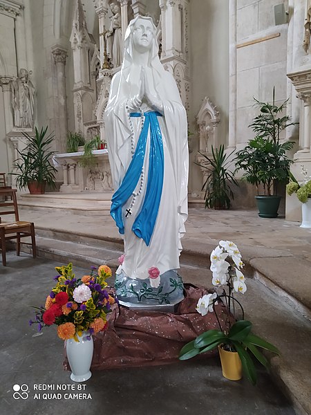
Français : Statue de Notre-Dame de Lourdes Le Pont Augis. La statue exposée devant le Sacré-Cœur, près de l’autel de la Sainte Vierge dans l'église Notre-Dame de Jallais, se dressait près du carrefour de La Croix qui chante au bord de la route du May à Chemillé. C’est une statue de la Vierge de Lourdes. Depuis 87 ans, de mémoire de Jallaisien, elle n’était jamais descendue de son socle. Comme elle était abimée, l’association « Jallais au fil du temps » a décidé de la restaurer, c’est Gérard Tricoire qui l’a repeinte. Pour cela il a préféré la démonter. Réalisée en fonte par la fonderie Union artistique de Vaucouleurs, elle a été installée en 1933 à la demande du Docteur Maximin Sourice après le décès de sa sœur, Jeanne. Le monument s’appelle Sourice – Bréheret ce qui correspond aux noms de leurs parents. Sur le territoire de Jallais on peut trouver 27 Calvaires, Croix et Statues sur les bords de route ou aux carrefours. Ils témoignent de la foi vivante des habitants de nos villages dans les temps passés. L’association a entrepris de reprendre leur entretien qui avait déjà été réalisé dans les années 1990. |
| Date | |
| Source | Own work |
| Author | Ideefixe |
| Camera location | | View this and other nearby images on: OpenStreetMap |
|---|
https://lesperanceaucoeurdesmauges.diocese49.org/la-vierge-du-pont-augis
Licensing
[edit]
I, the copyright holder of this work, hereby publish it under the following license:
This file is licensed under the Creative Commons Attribution-Share Alike 4.0 International license.
- You are free:
- to share – to copy, distribute and transmit the work
- to remix – to adapt the work
- Under the following conditions:
- attribution – You must give appropriate credit, provide a link to the license, and indicate if changes were made. You may do so in any reasonable manner, but not in any way that suggests the licensor endorses you or your use.
- share alike – If you remix, transform, or build upon the material, you must distribute your contributions under the same or compatible license as the original.
File history
Click on a date/time to view the file as it appeared at that time.
| Date/Time | Thumbnail | Dimensions | User | Comment | |
|---|---|---|---|---|---|
| current | 21:18, 5 May 2021 | | 3,000 × 4,000 (5.01 MB) | Ideefixe (talk | contribs) | Uploaded own work with UploadWizard |
You cannot overwrite this file.
File usage on Commons
There are no pages that use this file.
File usage on other wikis
The following other wikis use this file:
- Usage on fr.wikipedia.org