File:Steamship Tennessee remains 01.jpg
Original file (1,774 × 1,774 pixels, file size: 462 KB, MIME type: image/jpeg)
Captions
Summary[edit]
DescriptionSteamship Tennessee remains 01.jpg |
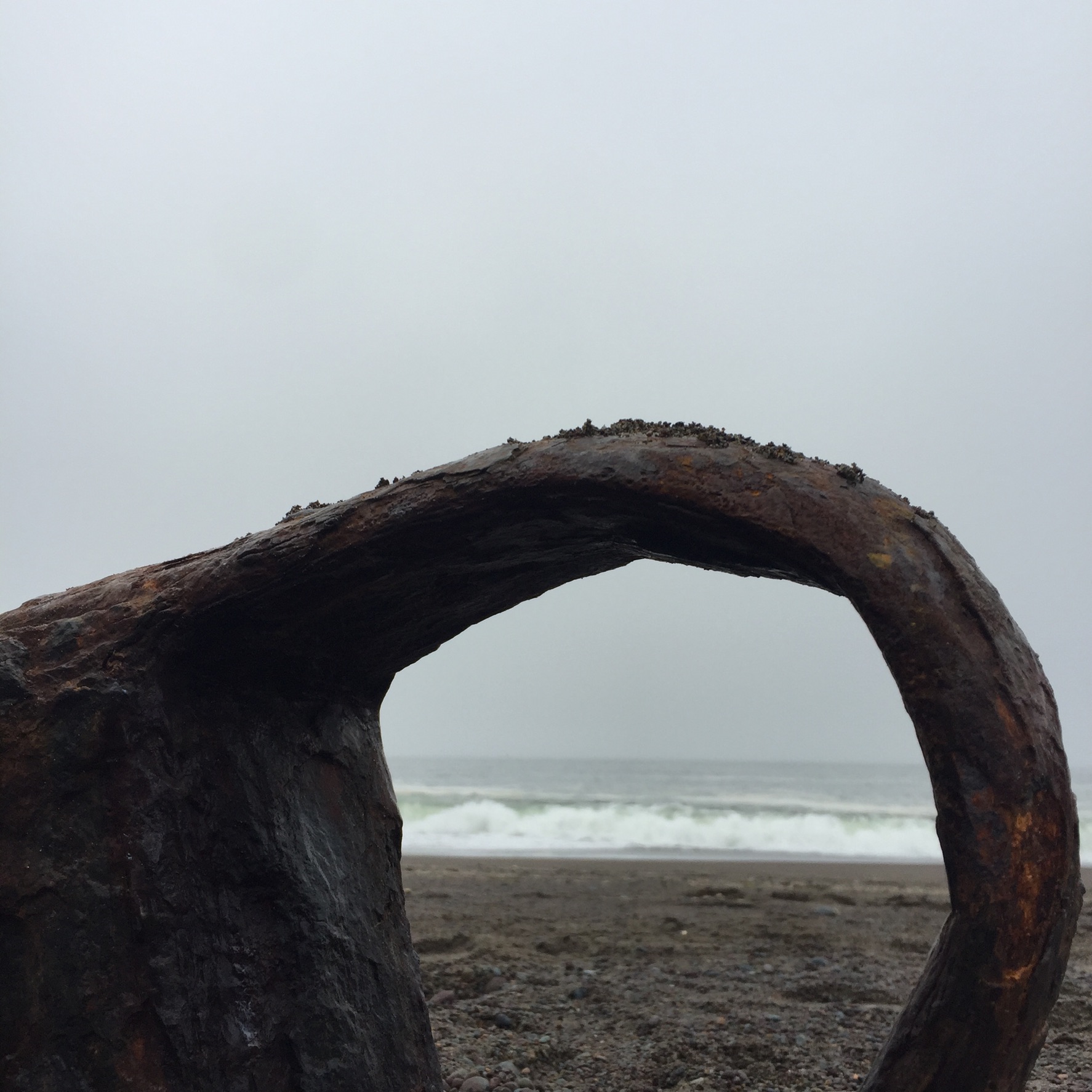
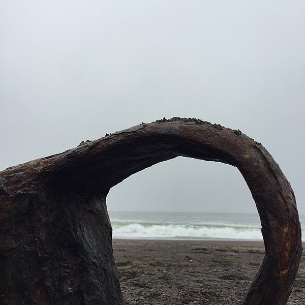
English: Remnants of the SS Tennessee at Tennessee Cove in Marin County California. The rusted remains of the SS Tennessee are visible at the south end of the beach, reached by a 1.7 mile hike from the parking lot at the end of Tennessee Valley Road, Mill Valley, CA. The ship broke up in the surf after running aground in the fog on March 6, 1853.
|
||
Date | |||
Source | Own work | ||
Author | Prb1848 |
Camera location | 37° 50′ 28.4″ N, 122° 33′ 05.45″ W | View this and other nearby images on: OpenStreetMap | 37.841222; -122.551514 |
---|
Licensing[edit]
- You are free:
- to share – to copy, distribute and transmit the work
- to remix – to adapt the work
- Under the following conditions:
- attribution – You must give appropriate credit, provide a link to the license, and indicate if changes were made. You may do so in any reasonable manner, but not in any way that suggests the licensor endorses you or your use.
- share alike – If you remix, transform, or build upon the material, you must distribute your contributions under the same or compatible license as the original.
This image was uploaded as part of Wiki Loves Monuments 2021.
Afrikaans ∙ Alemannisch ∙ azərbaycanca ∙ Bahasa Indonesia ∙ Bahasa Melayu ∙ Bikol Central ∙ bosanski ∙ brezhoneg ∙ català ∙ čeština ∙ Cymraeg ∙ dansk ∙ davvisámegiella ∙ Deutsch ∙ eesti ∙ English ∙ español ∙ Esperanto ∙ euskara ∙ français ∙ Frysk ∙ Gaeilge ∙ galego ∙ hrvatski ∙ Ido ∙ italiano ∙ latviešu ∙ Lëtzebuergesch ∙ Malagasy ∙ magyar ∙ Malti ∙ Nederlands ∙ norsk ∙ norsk nynorsk ∙ norsk bokmål ∙ polski ∙ português ∙ português do Brasil ∙ română ∙ shqip ∙ sicilianu ∙ slovenčina ∙ slovenščina ∙ suomi ∙ svenska ∙ Tagalog ∙ Türkçe ∙ Yorùbá ∙ Zazaki ∙ Ελληνικά ∙ беларуская ∙ беларуская (тарашкевіца) ∙ български ∙ кыргызча ∙ македонски ∙ русский ∙ српски / srpski ∙ українська ∙ ქართული ∙ հայերեն ∙ नेपाली ∙ हिन्दी ∙ বাংলা ∙ മലയാളം ∙ ไทย ∙ 한국어 ∙ +/− |
File history
Click on a date/time to view the file as it appeared at that time.
Date/Time | Thumbnail | Dimensions | User | Comment | |
---|---|---|---|---|---|
current | 20:29, 13 October 2021 | 1,774 × 1,774 (462 KB) | Prb1848 (talk | contribs) | Uploaded own work with UploadWizard |
You cannot overwrite this file.
File usage on Commons
There are no pages that use this file.
Metadata
This file contains additional information such as Exif metadata which may have been added by the digital camera, scanner, or software program used to create or digitize it. If the file has been modified from its original state, some details such as the timestamp may not fully reflect those of the original file. The timestamp is only as accurate as the clock in the camera, and it may be completely wrong.
Camera manufacturer | Apple |
---|---|
Camera model | iPhone 6 |
Exposure time | 1/2,198 sec (0.00045495905368517) |
F-number | f/2.2 |
ISO speed rating | 32 |
Date and time of data generation | 10:45, 22 September 2021 |
Lens focal length | 4.15 mm |
Latitude | 37° 50′ 28.4″ N |
Longitude | 122° 33′ 5.45″ W |
Altitude | 1.581 meters below sea level |
Horizontal resolution | 72 dpi |
Vertical resolution | 72 dpi |
Software used | 12.5.4 |
File change date and time | 10:45, 22 September 2021 |
Y and C positioning | Centered |
Exposure Program | Normal program |
Exif version | 2.21 |
Date and time of digitizing | 10:45, 22 September 2021 |
Meaning of each component |
|
APEX shutter speed | 11.101845839904 |
APEX aperture | 2.2750070480205 |
APEX brightness | 11.123062657306 |
APEX exposure bias | 0 |
Metering mode | Pattern |
Flash | Flash did not fire, compulsory flash suppression |
DateTimeOriginal subseconds | 135 |
DateTimeDigitized subseconds | 135 |
Supported Flashpix version | 1 |
Color space | sRGB |
Sensing method | One-chip color area sensor |
Scene type | A directly photographed image |
Exposure mode | Auto exposure |
White balance | Auto white balance |
Focal length in 35 mm film | 34 mm |
Scene capture type | Standard |
GPS time (atomic clock) | 17:45 |
Speed unit | Kilometers per hour |
Speed of GPS receiver | 0 |
Reference for direction of image | True direction |
Direction of image | 59.486236511782 |
Reference for bearing of destination | True direction |
Bearing of destination | 59.486236511782 |
GPS date | 22 September 2021 |
IIM version | 2 |
Structured data
Items portrayed in this file
depicts
22 September 2021
37°50'28.399"N, 122°33'5.450"W
0.00045495905368516833 second
2.2
4.15 millimetre
image/jpeg
- National Register of Historic Places with known IDs
- National Register of Historic Places missing SDC depicts
- National Register of Historic Places missing SDC location of creation
- Files with coordinates missing SDC location of creation
- CC-BY-SA-4.0
- Self-published work
- Images from Wiki Loves Monuments 2021
- Images from Wiki Loves Monuments 2021 in the United States
- Images from Wiki Loves Monuments 2021 in California
- Images from Wiki Loves Monuments missing SDC depicts
- Images from Wiki Loves Monuments missing SDC location of creation
- Wiki Loves Monuments 2021 in the United States unreviewed
- Uploaded via Campaign:wlm-us
- Pages with maps