File:StirlingRange L7 14aug99.jpg
Jump to navigation
Jump to search

Size of this preview: 800 × 495 pixels. Other resolutions: 320 × 198 pixels | 640 × 396 pixels | 1,024 × 634 pixels | 1,280 × 792 pixels | 2,945 × 1,822 pixels.
Original file (2,945 × 1,822 pixels, file size: 4.05 MB, MIME type: image/jpeg)
Captions
Captions
Add a one-line explanation of what this file represents
Summary
[edit]
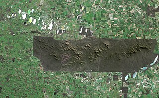
| Description | w:Stirling Range National Park, Western Australia. The sharp boundaries on all sides of the park show where agriculture immediately gives way to protected land. |
| Date | |
| Source | http://earthobservatory.nasa.gov/Newsroom/NewImages/images.php3?img_id=16950 |
| Author | Jesse Allen, NASA Earth Observatory, using data obtained from the Unversity of Maryland’s Global Land Cover Facility. |
| Permission (Reusing this file) |
Public domain |
Licensing
[edit]
| This file is in the public domain in the United States because it was solely created by NASA. NASA copyright policy states that "NASA material is not protected by copyright unless noted". (See Template:PD-USGov, NASA copyright policy page or JPL Image Use Policy.) | ||
 |
Warnings:
|
File history
Click on a date/time to view the file as it appeared at that time.
| Date/Time | Thumbnail | Dimensions | User | Comment | |
|---|---|---|---|---|---|
| current | 16:24, 9 May 2006 | | 2,945 × 1,822 (4.05 MB) | Holly Cheng (talk | contribs) | {{Information | Description=w:Stirling Range National Park, Western Australia. The sharp boundaries on all sides of the park show where agriculture immediately gives way to protected land. | Source=http://earthobservatory.nasa.gov/Newsroom/NewImages/i |
You cannot overwrite this file.
File usage on Commons
There are no pages that use this file.
File usage on other wikis
The following other wikis use this file:
- Usage on en.wikipedia.org
- Usage on es.wikipedia.org
- Usage on fr.wikipedia.org
- Usage on pl.wikipedia.org