File:Straube's Spezialkarte der nördlichen Vororte von Berlin 1909.jpg
Jump to navigation
Jump to search

Size of this preview: 800 × 590 pixels. Other resolutions: 320 × 236 pixels | 640 × 472 pixels | 1,024 × 755 pixels | 1,280 × 944 pixels | 2,560 × 1,887 pixels | 7,323 × 5,398 pixels.
Original file (7,323 × 5,398 pixels, file size: 20.81 MB, MIME type: image/jpeg)
Captions
Captions
Add a one-line explanation of what this file represents
Summary
[edit]| Title |
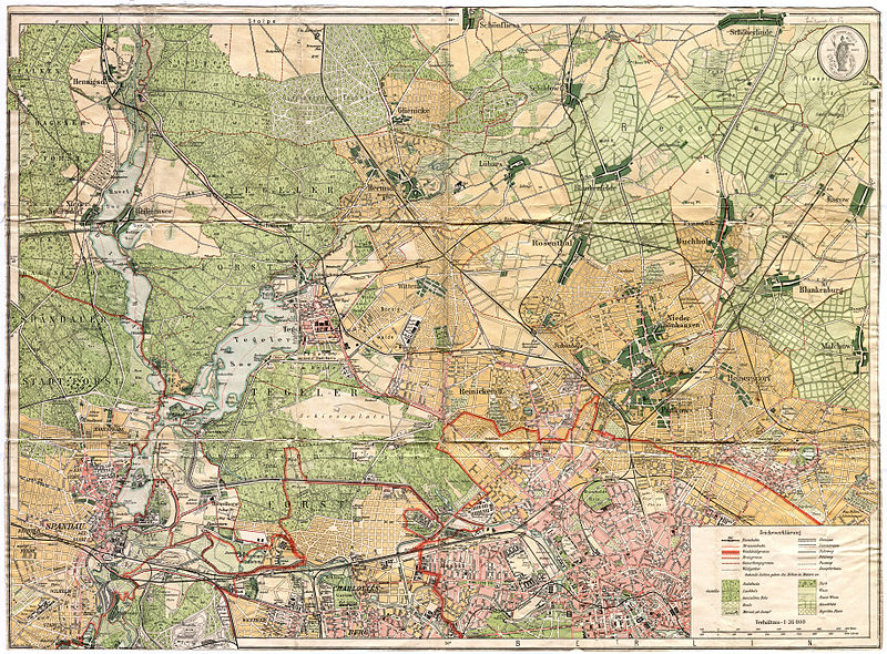
Straube's Spezialkarte der nördlichen Vororte von Berlin |
| Description |
Deutsch: Im Vergleich zu den Vorgängerplänen fehlt hier der Titel und die Herkunftsangaben unterhalb des Plans. Rechts oben ist jetzt die Schutzmarke von Straube eingefügt. Im Rahmen Längen- und Breitengrad (nach Ferro). Der Plan reicht östlich von Spandau bis westlich nach Weißensee, sowie südlich von Charlottenburg bis nördlich nach Schönfließ. |
| Date | |
| Source | Self-scanned |
| Creator | |
| Geotemporal data | |
| Map location | Berlin |
| Scale | 1:36,000 |
| Heading |
 |
| Georeferencing | |
| Bibliographic data | |
| Language | German |
| Archival data | |
| Dimensions | height: 46.9 cm (18.4 in); width: 60.8 cm (23.9 in) (height: 43 cm (16.9 in); width: 59.1 cm (23.2 in) map size) |
| Medium | chromolithograph |
| Notes |
Literatur
|
| Other versions |
|
.jpg)


Licensing
[edit]
|
This is a faithful photographic reproduction of a two-dimensional, public domain work of art. The work of art itself is in the public domain for the following reason:
The official position taken by the Wikimedia Foundation is that "faithful reproductions of two-dimensional public domain works of art are public domain".
This photographic reproduction is therefore also considered to be in the public domain in the United States. In other jurisdictions, re-use of this content may be restricted; see Reuse of PD-Art photographs for details. | ||||
File history
Click on a date/time to view the file as it appeared at that time.
| Date/Time | Thumbnail | Dimensions | User | Comment | |
|---|---|---|---|---|---|
| current | 18:16, 9 March 2013 | | 7,323 × 5,398 (20.81 MB) | Alexrk2 (talk | contribs) | == {{int:description}} == {{InteractiveViewer}} {{Information |Description='''Straube's Spezialkarte der nördlichen Vororte von Berlin'''<br/> * Format: 60,8 x 46,9 cm / 59,1 x 43,0 (n.d. Plan) * Orientierung: Nord * Maßstab: 1: 36 000 ... |
You cannot overwrite this file.
File usage on Commons
The following 4 pages use this file:
- File:Straube's Spezialkarte der nördlichen Vororte von Berlin 1904.jpg
- File:Straube's Spezialkarte der nördlichen Vororte von Berlin 1904 (Stresow-Ruhleben).jpg
- File:Straube's Spezialkarte der nördlichen Vororte von Berlin 1909.jpg
- File:Straube's Spezialkarte der nördlichen Vororte von Berlin 1909; Berlin-Reinickendorf (cropped).jpg
.jpg)