File:Strzałkowo (gmina) location map.png
Jump to navigation
Jump to search

Size of this preview: 561 × 599 pixels. Other resolutions: 225 × 240 pixels | 449 × 480 pixels | 662 × 707 pixels.
Original file (662 × 707 pixels, file size: 95 KB, MIME type: image/png)
Captions
Captions
Add a one-line explanation of what this file represents
| Description |
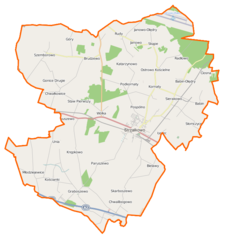
Polski: Mapa gminy Strzałkowo, Polska
English: Map of Gmina Strzałkowo, Poland |
|||||||||
| Date | ||||||||||
| Source | You may find a page on the OpenStreetMap wiki page for Strzałkowo (gmina) | |||||||||
| Creator |
OpenStreetMap contributors OpenStreetMap contributors |
|||||||||
| Permission (Reusing this file) |
OpenStreetMap data is available under the Open Database License (details). Map tiles are licensed under the Creative Commons Attribution-ShareAlike 2.0 license (CC-BY-SA 2.0).
This file is licensed under the Creative Commons Attribution-Share Alike 2.0 Generic license.
|
|||||||||
| Geotemporal data | ||||||||||
| Bounding box |
|
|||||||||
| Georeferencing | If inappropriate please set warp_status = skip to hide. | |||||||||
File history
Click on a date/time to view the file as it appeared at that time.
| Date/Time | Thumbnail | Dimensions | User | Comment | |
|---|---|---|---|---|---|
| current | 07:40, 30 December 2014 | | 662 × 707 (95 KB) | VanWiel (talk | contribs) | {{OpenStreetMap | name = Strzałkowo (gmina) | location = Strzałkowo (gmina) | description = {{pl|Mapa gminy Strzałkowo, Polska}} {{en|Map of Gmina Strzałkowo, Poland}} | top = 52.3913 | bottom =... |
You cannot overwrite this file.
File usage on Commons
There are no pages that use this file.
File usage on other wikis
The following other wikis use this file:
- Usage on fr.wikipedia.org
- Usage on pl.wikipedia.org
- Strzałkowo (gmina)
- Babin-Olędry
- Gonice Drugie
- Janowo-Olędry
- Krępkowo (województwo wielkopolskie)
- Kornaty (województwo wielkopolskie)
- Młodziejewice
- Ostrowo Kościelne
- Paruszewo
- Szemborowo
- Unia (województwo wielkopolskie)
- Brudzewo (województwo wielkopolskie)
- Chwałkowice (województwo wielkopolskie)
- Katarzynowo (powiat słupecki)
- Skarboszewo (województwo wielkopolskie)
- Skąpe (powiat słupecki)
- Strzałkowo (województwo wielkopolskie)
- Wólka (województwo wielkopolskie)
- Babin (powiat słupecki)
- Bielawy (gmina Strzałkowo)
- Chwalibogowo (powiat słupecki)
- Graboszewo (powiat słupecki)
- Janowo (powiat słupecki)
- Kościanki (powiat słupecki)
- Sierakowo (powiat słupecki)
- Staw (powiat słupecki)
- Rudy (województwo wielkopolskie)
- Słomczyce
- Góry (powiat słupecki)
- Ciosna (województwo wielkopolskie)
- Kokczyn Pierwszy
- Kokczyn Drugi
- Pospólno
- Podkornaty
- Staw Drugi
- Strzałkowo (stacja kolejowa)
- Uścięcin
- Janowo-Cegielnia
- Radłowo (województwo wielkopolskie)
- Łężec (województwo wielkopolskie)
- Radłowo Leśne
- Wólka (przystanek kolejowy)
- Cmentarz jeńców wojennych i internowanych pod Strzałkowem
- Kościół św. Małgorzaty w Graboszewie
- Parafia św. Doroty w Strzałkowie
- Parafia św. Marii Magdaleny w Brudzewie
- Parafia Nawiedzenia Najświętszej Maryi Panny w Ostrowie Kościelnym
- Parafia Świętej Trójcy w Skarboszewie
- Parafia św. Małgorzaty w Graboszewie
View more global usage of this file.
_location_map.png)
_location_map.png&oldid=476268660)