File:Suntopia Okayama Soja, CCG20071-C16-49.jpg
Jump to navigation
Jump to search

Size of this preview: 401 × 600 pixels. Other resolutions: 160 × 240 pixels | 321 × 480 pixels | 929 × 1,389 pixels.
Original file (929 × 1,389 pixels, file size: 657 KB, MIME type: image/jpeg)
Captions
Captions
Add a one-line explanation of what this file represents
Summary[edit]
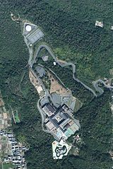
| Description |
日本語: 岡山県総社市にある、サントピア岡山総社付近の空中写真。
English: This is an aerial photo of Suntopia Okayama Soja and its surroundings. Suntopia is located in Soja, Okayama, Japan. |
| Date | |
| Source | 国土画像情報(カラー空中写真) (整理番号:CCG20071、コース番号:C16、写真番号:49、撮影年月日:2007年10月22日、撮影地域:倉敷、撮影高度:2200m、撮影縮尺:1/10000、カメラ名称:UCD、焦点距離:105.200mm、カラー種別:カラー、写真種別:デジタル、撮影計画機関:国土地理院、市区町村名: 総社市 |
| Author |
English: Geographical Survey Institute of Japan 日本語: 国土地理院 |
Licensing[edit]

|
The copyright holder of this file, Ministry of Land, Infrastructure, Transport and Tourism, allows anyone to use it for any purpose, provided that the copyright holder is properly attributed. Redistribution, derivative work, commercial use, and all other use is permitted. |
Attribution:
National Land Image Information (Color Aerial Photographs), created by Ministry of Land, Infrastructure, Transport and Tourism, distributed by Geospatial Information Authority of Japan
|

File history
Click on a date/time to view the file as it appeared at that time.
| Date/Time | Thumbnail | Dimensions | User | Comment | |
|---|---|---|---|---|---|
| current | 11:43, 24 August 2016 | | 929 × 1,389 (657 KB) | Miyuki Meinaka (talk | contribs) | User created page with UploadWizard |
You cannot overwrite this file.
File usage on Commons
There are no pages that use this file.
File usage on other wikis
The following other wikis use this file:
- Usage on ja.wikipedia.org