File:Superpower map 1945.png
跳转到导航
跳转到搜索

本预览的尺寸:800 × 351像素。 其他分辨率:320 × 140像素 | 640 × 281像素 | 1,425 × 625像素。
原始文件 (1,425 × 625像素,文件大小:23 KB,MIME类型:image/png)
说明
说明
添加一行文字以描述该文件所表现的内容
Legend
[编辑]

|
此map图片可使用矢量图形重新创建为SVG文件。这具有很多好处;更多信息请参见共享资源:待清理媒体。如果存在此图片的SVG格式,请将其上传,然后将此模板替换为
{{vector version available|新图片名称}}。
建议您将SVG命名为“Superpower map 1945.svg”,这样在使用Vector version available(或Vva)模板时就不需要填写新图片名称参数。 |
English:
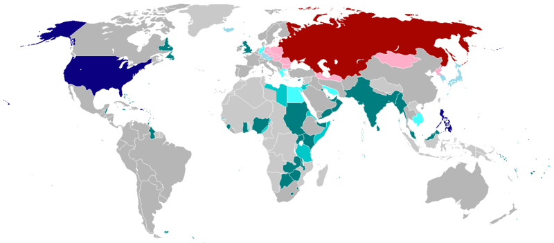
English (en): Map of the world in 1945 with dependencies in lighter shading and respective superpowers at the time.
British Trust Territories
British Postwar Occupations
US postwar Occupations
Soviet postwar Occupations
বাংলা :
বাংলা (bn): ১৯৪৫ সালের মানচিত্রে পরাশক্তি ও তাদের উপর নির্ভর রাষ্ট্রসমূহ
ব্রিটিশ সাম্রাজ্য
ব্রিটিশদের বিশ্বস্ত অঞ্চলসমূহ
যুক্তরাষ্ট্র
যুক্তরাষ্ট্র বিশ্বস্ত অঞ্চলসমুহ
সোভিয়েত ইউনিয়ন
| 本作品已被作者英语维基百科的projectname释出到公有领域。这适用于全世界。 在一些国家这可能不合法;如果是这样的话,那么: projectname无条件地授予任何人以任何目的使用本作品的权利,除非这些条件是法律规定所必需的。 |
.
文件历史
点击某个日期/时间查看对应时刻的文件。
| 日期/时间 | 缩略图 | 大小 | 用户 | 备注 | |
|---|---|---|---|---|---|
| 当前 | 2020年10月19日 (一) 01:25 | | 1,425 × 625(23 KB) | RickoTroanman22(留言 | 贡献) | Fixed Hong Kong, also Tibet did not claim Inner Tibet. |
| 2019年1月6日 (日) 22:22 |  | 1,425 × 625(39 KB) | BMacZero(留言 | 贡献) | colored most Aleutian Islands as United States | |
| 2017年7月2日 (日) 14:41 |  | 1,425 × 625(39 KB) | Fireinacrowdedtheatre(留言 | 贡献) | Changed New Zealand to grey; the majority-white Dominions were not under British control by 1945 (except Newfoundland). Also added Soviet occupation of central Europe and Mongolia, British occupation of Greece, American occupation of Iceland, and the B... | |
| 2014年10月7日 (二) 23:11 |  | 1,425 × 625(43 KB) | ZaidRock11(留言 | 贡献) | Added post-World War II occupations in 1945 (Germany, Austria, Korea, Japan, Kwantung, Indochina); New Zealand did get full independence until 1947. | |
| 2013年6月9日 (日) 07:41 |  | 1,425 × 625(36 KB) | Elmor(留言 | 贡献) | Germany occupation zones+Saar | |
| 2012年2月10日 (五) 00:11 |  | 1,425 × 625(51 KB) | Quintucket(留言 | 贡献) | Reverted to version as of 17:28, 20 August 2011 I missed the addition of Trust territories | |
| 2012年1月28日 (六) 07:14 |  | 1,357 × 628(52 KB) | Quintucket(留言 | 贡献) | Reverted to version as of 21:44, 27 June 2007 Like User:Swarm said, India and the Philippines were still colonies at the time. Belarus and Ukraine were both UN members, which doesn't mean we should show them as non-USSR | |
| 2011年12月1日 (四) 08:12 |  | 1,425 × 625(57 KB) | 23prootie~commonswiki(留言 | 贡献) | The Philippines and India are United Nations members in 1945 with guaranteed independence. They don't count. | |
| 2011年8月20日 (六) 17:28 |  | 1,425 × 625(51 KB) | Swarm(留言 | 贡献) | re-add Philippines, which did not gain independence until 1946. It was commonwealth status they gained in 1934, not independence. | |
| 2010年10月27日 (三) 00:29 |  | 1,425 × 625(51 KB) | Vadac(留言 | 贡献) | Clearer version, the Philippines became independent in 1934, added Mandates and Trust Territories. |
您不可以覆盖此文件。
文件用途
全域文件用途
以下其他wiki使用此文件:
- ar.wikipedia.org上的用途
- ast.wikipedia.org上的用途
- az.wikipedia.org上的用途
- be.wikipedia.org上的用途
- el.wikipedia.org上的用途
- en.wikipedia.org上的用途
- es.wikipedia.org上的用途
- fa.wikipedia.org上的用途
- fr.wikipedia.org上的用途
- he.wikipedia.org上的用途
- hy.wikipedia.org上的用途
- id.wikipedia.org上的用途
- ja.wikipedia.org上的用途
- ko.wikipedia.org上的用途
- lt.wikipedia.org上的用途
- no.wikipedia.org上的用途
- pl.wikipedia.org上的用途
- pt.wikipedia.org上的用途
- ru.wikipedia.org上的用途
- sco.wikipedia.org上的用途
- ta.wikipedia.org上的用途
- th.wikipedia.org上的用途
- uz.wikipedia.org上的用途
- zh-yue.wikipedia.org上的用途
- zh.wikipedia.org上的用途