File:Surface Map of Pluto.jpg

元のファイル (2,813 × 1,737 ピクセル、ファイルサイズ: 226キロバイト、MIME タイプ: image/jpeg)
キャプション
キャプション
| 解説 |
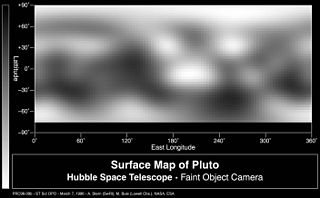
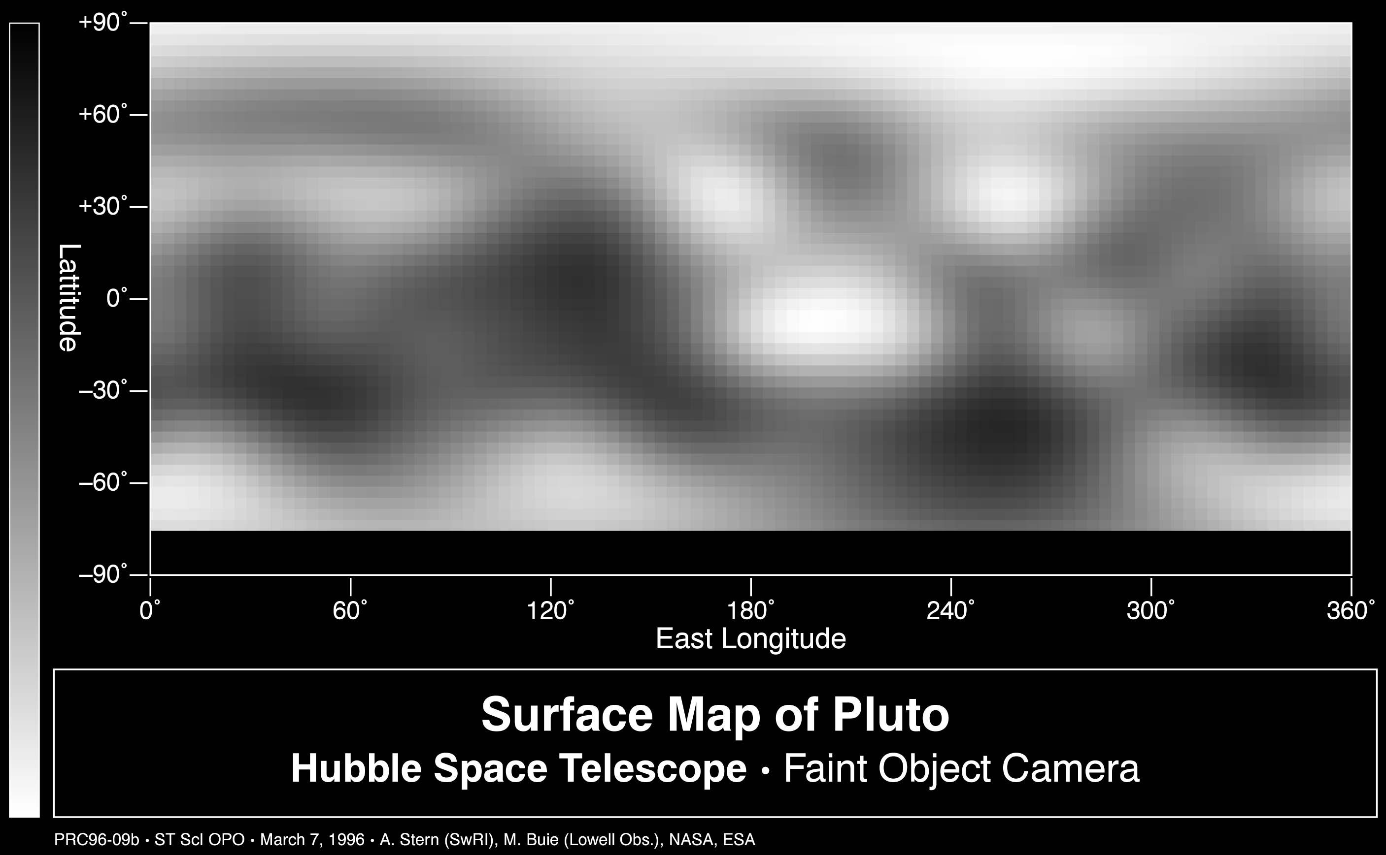
This is the first image-based surface map of Pluto. This map was assembled by computer image processing software from four separate images of Pluto's disk taken with the European Space Agency's (ESA) Faint Object Camera (FOC) aboard NASA's Hubble Space Telescope. Hubble imaged nearly the entire surface, as Pluto rotated on its axis in late June and early July 1994. The map, which covers 85% of the planet's surface, confirms that Pluto has a dark equatorial belt and bright polar caps, as inferred from ground-based light curves obtained during the mutual eclipses that occurred between Pluto and its satellite Charon in the late 1980s. The brightness variations in this map may be due to topographic features such as basins and fresh impact craters. However, most of the surface features unveiled by Hubble are likely produced by the complex distribution of frosts that migrate across Pluto's surface with its orbital and seasonal cycles. Names may later be proposed for some of the larger regions. Image reconstruction techniques smooth out the coarse pixels in the four raw images to reveal major regions where the surface is either bright or dark. The black strip across the bottom corresponds to the region surrounding Pluto's south pole, which was pointed away from Earth when the observations were made, and could not be imaged. Pluto itself probably shows even more contrast and perhaps sharper boundaries between light and dark areas than is shown here, but Hubble's resolution (just like early telescopic views of Mars) tends to blur edges and blend together small features sitting inside larger ones. Italiano: Mappa di Plutone basata su osservazioni del telescopio Hubble. |
| 日付 | image taken in Jun. - Jul. 1994 |
| 原典 |
NASA planetary photojournal |
| 作者 | Alan Stern (Southwest Research Institute)/Marc Buie (Lowell Observatory)/NASA/ESA |
| 許可 (ファイルの再利用) |
Copyright information from http://www.jpl.nasa.gov/images/policy/index.cfm - Unless otherwise noted, images and video on JPL public web sites (public sites ending with a jpl.nasa.gov address) may be used for any purpose without prior permission [...] |
| このタグは、添付された著作物の著作権状況を示すものではありません。通常の著作権タグも必要です。Commons:ライセンシングもご覧ください。 他言語での翻訳:
|
| このファイルはアメリカ航空宇宙局(NASA)によって作成されたものです。NASAの著作権の方針では、特記事項が無い場合、NASAの資料はパブリックドメインとなります。 (詳しくはTemplate:PD-USGov、NASAの著作権の方針について(英語)又はジェット推進研究所(JPL)の画像使用に関するガイドライン(英語)をご覧ください。) |
||
 |
注意事項:
|
ファイルの履歴
過去の版のファイルを表示するには、その版の日時をクリックしてください。
| 日付と時刻 | サムネイル | 寸法 | 利用者 | コメント | |
|---|---|---|---|---|---|
| 現在の版 | 2006年1月31日 (火) 10:56 | | 2,813 × 1,737 (226キロバイト) | Arnomane (トーク | 投稿記録) | higher resolution |
| 2005年9月1日 (木) 20:47 |  | 1,272 × 786 (78キロバイト) | Lotse (トーク | 投稿記録) | *'''Original Caption Released with Image:''' This is the first image-based surface map of the solar system's most remote planet, Pluto. This map was assembled by computer image processing software from four separate images of Pluto's disk taken with the |
このファイルは上書きできません。
ファイルの使用状況
このファイルを使用しているページはありません。
グローバルなファイル使用状況
以下に挙げる他のウィキがこの画像を使っています:
- de.wikipedia.org での使用状況
- en.wikipedia.org での使用状況
- fr.wikiversity.org での使用状況
- ja.wikipedia.org での使用状況
- lb.wikipedia.org での使用状況
- mr.wikipedia.org での使用状況
- nds.wikipedia.org での使用状況
- ro.wikipedia.org での使用状況