File:Sutton Hoo map 2.svg
Jump to navigation
Jump to search

Size of this PNG preview of this SVG file: 354 × 417 pixels. Other resolutions: 204 × 240 pixels | 407 × 480 pixels | 652 × 768 pixels | 869 × 1,024 pixels | 1,739 × 2,048 pixels.
Original file (SVG file, nominally 354 × 417 pixels, file size: 118 KB)
Captions
Captions
Sutton Hoo map
Summary
[edit]
| Description |
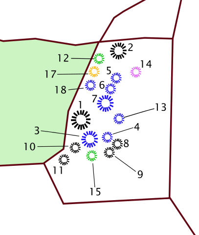
English: Sutton Hoo map |
| Date | 15 July 2011 (original upload date) |
| Source | Own work, based on map of the Sutton Hoo burial ground, in Carver, Martin, 'Sutton Hoo:Burial Ground of Kings?' , p. 135 (ISBN 0-7141-0599-6) and OS map of the Sutton Hoo burial group (http://www.old-maps.co.uk/maps.html?txtXCoord=628798&txtYCoord=248700). Mounds 17 and 14 individually coloured, cremations in blue, woodland in green, from Carver, p. 179. |
| Author | Amitchell125 at English Wikipedia |
Licensing
[edit]
Amitchell125 at English Wikipedia, the copyright holder of this work, hereby publishes it under the following license:
This file is licensed under the Creative Commons Attribution 3.0 Unported license.
Attribution: Amitchell125 at English Wikipedia
- You are free:
- to share – to copy, distribute and transmit the work
- to remix – to adapt the work
- Under the following conditions:
- attribution – You must give appropriate credit, provide a link to the license, and indicate if changes were made. You may do so in any reasonable manner, but not in any way that suggests the licensor endorses you or your use.
Original upload log
[edit]
Transferred from en.wikipedia to Commons by James Steakley using CommonsHelper.
The original description page was here. All following user names refer to en.wikipedia.
- 2011-07-15 19:47 Amitchell125 354×417× (120581 bytes) Own work, based on map of the Sutton Hoo burial ground, in Carver, Martin, 'Sutton Hoo:Burial Ground of Kings?' , p. 135 ({{ISBN|0-7141-0599-6}}) and OS map of the Sutton Hoo burial group (http://www.old-maps.co.uk/maps.html?txtXCoord=628798&txtYCoord=248700)
File history
Click on a date/time to view the file as it appeared at that time.
| Date/Time | Thumbnail | Dimensions | User | Comment | |
|---|---|---|---|---|---|
| current | 06:58, 7 May 2013 | | 354 × 417 (118 KB) | File Upload Bot (Magnus Manske) (talk | contribs) | Transfered from en.wikipedia by User:Jdsteakley using CommonsHelper |
You cannot overwrite this file.
File usage on Commons
The following page uses this file:
File usage on other wikis
The following other wikis use this file:
- Usage on en.wikipedia.org
- Usage on es.wikipedia.org
- Usage on fr.wikipedia.org
- Usage on uk.wikipedia.org