File:Svratouch, CZ180409-078.jpg
![File:Svratouch, CZ180409-078.jpg](https://upload.wikimedia.org/wikipedia/commons/thumb/2/23/Svratouch%2C_CZ180409-078.jpg/800px-Svratouch%2C_CZ180409-078.jpg?20180411092326)
Original file (4,896 × 2,752 pixels, file size: 3.9 MB, MIME type: image/jpeg)
Captions
Captions
Summary
[edit]DescriptionSvratouch, CZ180409-078.jpg |
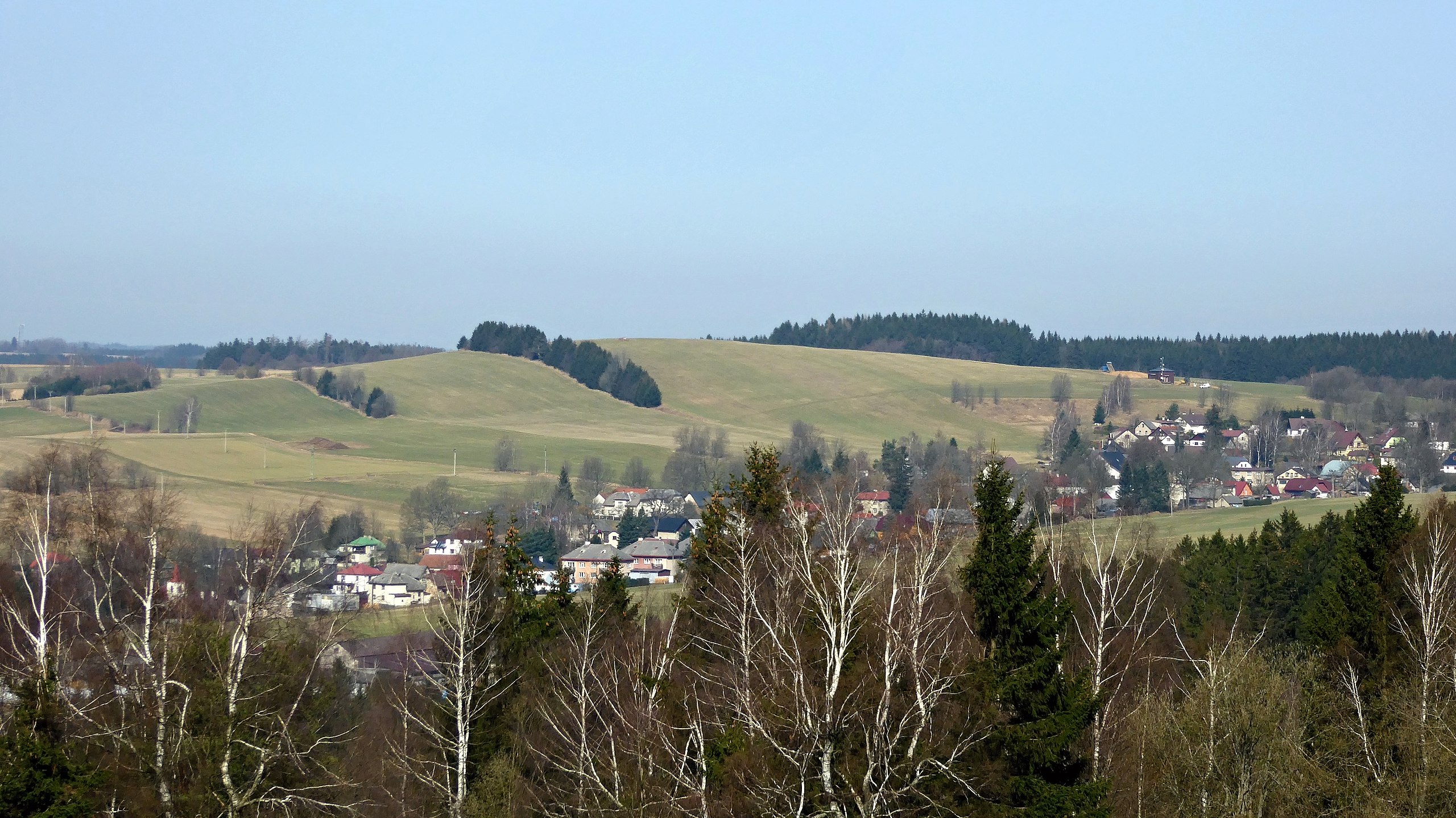
English: View from the slope no name (748,9 m asl.) to the top "U oběšeného" with an altitude of 737.4 m (in the middle of the shot) above the village of "Svratouch". Geographical name in czech written form "U oběšeného" is the standard name of the geographic object of hill type. The highest peak of the Iron Mountains lies in the south-eastern part of the mountain range with name "Sečská" Highlands, in the geomorphological district "Kameničská" Highlands. Photo-location: Czechia, Pardubice Region, the village of "Svratouch".
Source of information:
Čeština: Pohled z bezejmenné svahové kupy (748,9 m n. m.) na vrchol U oběšeného s nadmořskou výškou 737,4 m (uprostřed záběru) nad obcí Svratouch. Zeměpisný název (oronymum) v písemné podobě U oběšeného je standardizované jméno geografického objektu typu kopce. Nejvyšší vrchol Železných hor leží v jihovýchodní části pohoří nazvané Sečská vrchovina, na okraji geomorfologického okrsku Kameničská vrchovina. Foto-lokace: Česko, Pardubický kraj, obec Svratouch, bezejmenná svahová kupa (748,9 m), cca 100 m zhušťovací bod Karlštejn (748,5 m), louka (304°).
Zdroj informací:
|
Date | |
Source | Own work |
Author | Josef Kreuz (PEPan) |
Camera location | 49° 43′ 05.61″ N, 16° 03′ 13.36″ E ![]() ![]() | View this and other nearby images on: OpenStreetMap | ![]() |
---|
Licensing
[edit]![w:en:Creative Commons](https://upload.wikimedia.org/wikipedia/commons/thumb/7/79/CC_some_rights_reserved.svg/90px-CC_some_rights_reserved.svg.png)
![attribution](https://upload.wikimedia.org/wikipedia/commons/thumb/1/11/Cc-by_new_white.svg/24px-Cc-by_new_white.svg.png)
![share alike](https://upload.wikimedia.org/wikipedia/commons/thumb/d/df/Cc-sa_white.svg/24px-Cc-sa_white.svg.png)
- You are free:
- to share – to copy, distribute and transmit the work
- to remix – to adapt the work
- Under the following conditions:
- attribution – You must give appropriate credit, provide a link to the license, and indicate if changes were made. You may do so in any reasonable manner, but not in any way that suggests the licensor endorses you or your use.
- share alike – If you remix, transform, or build upon the material, you must distribute your contributions under the same or compatible license as the original.
File history
Click on a date/time to view the file as it appeared at that time.
Date/Time | Thumbnail | Dimensions | User | Comment | |
---|---|---|---|---|---|
current | 09:23, 11 April 2018 | ![]() | 4,896 × 2,752 (3.9 MB) | PEPan (talk | contribs) | User created page with UploadWizard |
You cannot overwrite this file.
File usage on Commons
There are no pages that use this file.
File usage on other wikis
The following other wikis use this file:
- Usage on cs.wikipedia.org
Metadata
This file contains additional information such as Exif metadata which may have been added by the digital camera, scanner, or software program used to create or digitize it. If the file has been modified from its original state, some details such as the timestamp may not fully reflect those of the original file. The timestamp is only as accurate as the clock in the camera, and it may be completely wrong.
Image title |
|
---|---|
Camera manufacturer | Panasonic |
Camera model | DMC-TZ60 |
Author | Josef Kreuz |
Copyright holder |
|
Exposure time | 1/500 sec (0.002) |
F-number | f/5.4 |
ISO speed rating | 100 |
Date and time of data generation | 09:17, 9 April 2018 |
Lens focal length | 27.1 mm |
User comments | EN: View from the slope no name (748,9 m asl.) to the top "U oběšeného" with an altitude of 737.4 m (in the middle of the shot) above the village of "Svratouch". Geographical name in czech written form "U oběšeného" is the standard name of the geographic object of hill type. The highest peak of the Iron Mountains lies in the south-eastern part of the mountain range with name "Sečská" Highlands, in the geomorphological district "Kameničská" Highlands. Photo-location: Czechia, Pardubice Region, the village of "Svratouch".
Source of information:
CZ: Pohled z bezejmenné svahové kupy (748,9 m n. m.) na vrchol U oběšeného s nadmořskou výškou 737,4 m (uprostřed záběru) nad obcí Svratouch. Zeměpisný název (oronymum) v písemné podobě U oběšeného je standardizované jméno geografického objektu typu kopce. Nejvyšší vrchol Železných hor leží v jihovýchodní části pohoří nazvané Sečská vrchovina, na okraji geomorfologického okrsku Kameničská vrchovina. Foto-lokace: Česko, Pardubický kraj, obec Svratouch, bezejmenná svahová kupa (748,9 m), cca 100 m zhušťovací bod Karlštejn (748,5 m), louka (304°). Zdroj informací:
|
Latitude | 49° 43′ 5.61″ N |
Longitude | 16° 3′ 13.36″ E |
Short title |
|
Label | Yellow |
City shown | Svratouch |
Compression scheme | Uncompressed |
Pixel composition | RGB |
Orientation | Normal |
Horizontal resolution | 180 dpi |
Vertical resolution | 180 dpi |
Data arrangement | chunky format |
Software used | Zoner Photo Studio 18 |
File change date and time | 11:21, 11 April 2018 |
Y and C positioning | Centered |
Exposure Program | Landscape mode (for landscape photos with the background in focus) |
Exif version | 2.3 |
Date and time of digitizing | 09:17, 9 April 2018 |
Meaning of each component |
|
Image compression mode | 4 |
APEX exposure bias | 0 |
Maximum land aperture | 4.8671875 APEX (f/5.4) |
Metering mode | Pattern |
Light source | Unknown |
Flash | Flash did not fire, compulsory flash suppression |
Supported Flashpix version | 1 |
Color space | sRGB |
Sensing method | One-chip color area sensor |
File source | Digital still camera |
Scene type | A directly photographed image |
Custom image processing | Normal process |
Exposure mode | Auto exposure |
White balance | Auto white balance |
Digital zoom ratio | 0 |
Focal length in 35 mm film | 182 mm |
Scene capture type | Standard |
Scene control | None |
Contrast | Normal |
Saturation | Normal |
Sharpness | Normal |
GPS time (atomic clock) | 08:15 |
Receiver status | Measurement in progress |
Measurement mode | 2-dimensional measurement |
Measurement precision | Fair (1.1) |
Geodetic survey data used | WGS-84 |
Name of GPS area | 䜀漀氀昀 挀氀甀戀 匀瘀爀愀琀欀愀 㤀㌀㈀ |
GPS date | 9 April 2018 |
GPS tag version | 0.0.3.2 |
Keywords | Svratouch |
Writer | Josef Kreuz |
Province or state shown | Pardubický kraj |
Country shown | Česko |
Code for country shown | CZ |
Sublocation of city shown | Karlštejn |