File:TC Ami 15 jan 2003 0125Z.jpg
Jump to navigation
Jump to search

Size of this preview: 490 × 599 pixels. Other resolutions: 196 × 240 pixels | 393 × 480 pixels | 628 × 768 pixels | 838 × 1,024 pixels | 1,676 × 2,048 pixels | 7,200 × 8,800 pixels.
Original file (7,200 × 8,800 pixels, file size: 8.14 MB, MIME type: image/jpeg)
Captions
Captions
Add a one-line explanation of what this file represents
| Warning | The original file is very high-resolution. It might not load properly or could cause your browser to freeze when opened at full size. |
|---|
Summary
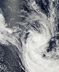
[edit]| Description | On January 13, 2003, Tropical Cyclone Ami was located approximately 265 miles (307 km) northeast of Suva on Fiji and was packing winds of 89 mph (142 km/hr) with gusts to 104 mph (166 km/hr). Ami was expected to intensify over the following 12 hours, but then quickly undergo a transition to an extratropical system in 24-36 hours. This image was acquired by the Moderate Resolution Imaging Spectroradiometer (MODIS) on the Aqua satellite. | |||||
| Date | ||||||
| Source | http://visibleearth.nasa.gov/view_rec.php?id=4505 | |||||
| Author | Jeff Schmaltz, MODIS Rapid Response Team, NASA/GSFC | |||||
| Permission (Reusing this file) |
|

File history
Click on a date/time to view the file as it appeared at that time.
| Date/Time | Thumbnail | Dimensions | User | Comment | |
|---|---|---|---|---|---|
| current | 16:00, 29 November 2006 | | 7,200 × 8,800 (8.14 MB) | Good kitty (talk | contribs) | == Summary == {{Information |Description=On January 13, 2003, Tropical Cyclone Ami was located approximately 265 miles (307 km) northeast of Suva on Fiji and was packing winds of 89 mph (142 km/hr) with gusts to 104 mph (166 km/hr). Ami was expected to in |
You cannot overwrite this file.
File usage on Commons
There are no pages that use this file.