File:TC Bernie NOAA.jpg
Jump to navigation
Jump to search
No higher resolution available.
TC_Bernie_NOAA.jpg (696 × 537 pixels, file size: 184 KB, MIME type: image/jpeg)
Captions
Captions
Add a one-line explanation of what this file represents
Summary
[edit]
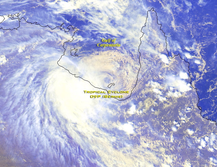
| Description | Tropical Cyclone 09P (Bernie) was located over the Gulf of Carpentaria near 16.2S 139.0E at 0600 UTC. Bernie has been moving southward at 7 knots with maximum sustained winds estimated at 40 knots, gusts to 50 knots. |
| Date | |
| Source | http://www.osei.noaa.gov/Events/Tropical/S_Pacific/2002/TRCbernie004_GM.jpg |
| Author | NOAA |
Licensing
[edit]
This image is in the public domain because it contains materials that originally came from the U.S. National Oceanic and Atmospheric Administration, taken or made as part of an employee's official duties.
|
File history
Click on a date/time to view the file as it appeared at that time.
| Date/Time | Thumbnail | Dimensions | User | Comment | |
|---|---|---|---|---|---|
| current | 10:55, 28 May 2007 | | 696 × 537 (184 KB) | RaNdOm26~commonswiki (talk | contribs) | {{Information |Description = Tropical Cyclone 09P (Bernie) was located over the Gulf of Carpentaria near 16.2S 139.0E at 0600 UTC. Bernie has been moving southward at 7 knots with maximum sustained winds estimated at 40 knots, |
You cannot overwrite this file.
File usage on Commons
There are no pages that use this file.