File:TC Boloetse 05 feb 2006 1045Z.jpg

Исходный файл (7822 × 7822 пкс, размер файла: 7,79 МБ, MIME-тип: image/jpeg)
Краткие подписи
Краткие подписи
Краткое описание
[править]| Описание |
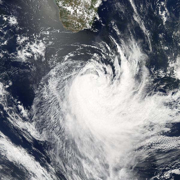
Tropical Cyclone Boloetse was winding down on February 5, 2006, when the Moderate Resolution Imaging Spectroradiometer (MODIS) on the Aqua satellite captured this image at 10:45 UTC (1:45 p.m. local time). At this time, Boloetse was heading into the southern Indian Ocean after brushing against the southern end of Madagascar. The cyclone had sustained winds of around 120 kilometers per hour (75 miles per hour), classifying it as a Category 1 storm on the Saffir-Simpson scale. This was less intense than the previous day, and forecasters were predicting the storm would continue to diminish in strength as it traveled southeast away from the African coast. Tropical Cyclone Boloetse initially formed in the western Indian Ocean and traveled west, crossing the island of Madagascar as a tropical storm in late January 2006, with moderately strong rains. The storm intensity declined to tropical-depression strength as it crossed the mountainous ridgeline that runs along the eastern shore of Madagascar. However, once the storm system reached the warm waters of the Mozambique Channel, the tropical depression re-organized and built up enough strength to become a tropical cyclone. Once there, the storm reversed direction and headed southeast, taking it across Madagascar once again. It struck a glancing blow over the island’s southern tip on February 4, 2006. |
|||||
| Дата | ||||||
| Источник | http://earthobservatory.nasa.gov/NaturalHazards/natural_hazards_v2.php3?img_id=13352 | |||||
| Автор | NASA image created by Jesse Allen, Earth Observatory, using data obtained courtesy of the MODIS Rapid Response team. | |||||
| Права (Повторное использование этого файла) |
|

История файла
Нажмите на дату/время, чтобы увидеть версию файла от того времени.
| Дата/время | Миниатюра | Размеры | Участник | Примечание | |
|---|---|---|---|---|---|
| текущий | 16:29, 18 ноября 2006 | | 7822 × 7822 (7,79 МБ) | Good kitty (обсуждение | вклад) | == Summary == {{Information |Description=Tropical Cyclone Boloetse was winding down on February 5, 2006, when the Moderate Resolution Imaging Spectroradiometer (MODIS) on the Aqua satellite captured this image at 10:45 UTC (1:45 p.m. local time). At this |
Вы не можете перезаписать этот файл.
Использование файла
Нет страниц, использующих этот файл.