File:TNF-NASAmap-Labels.png
跳至導覽
跳至搜尋
無更高解析度可提供。
TNF-NASAmap-Labels.png (720 × 436 像素,檔案大小:431 KB,MIME 類型:image/png)
說明
說明
添加單行說明來描述出檔案所代表的內容
摘要
[編輯]
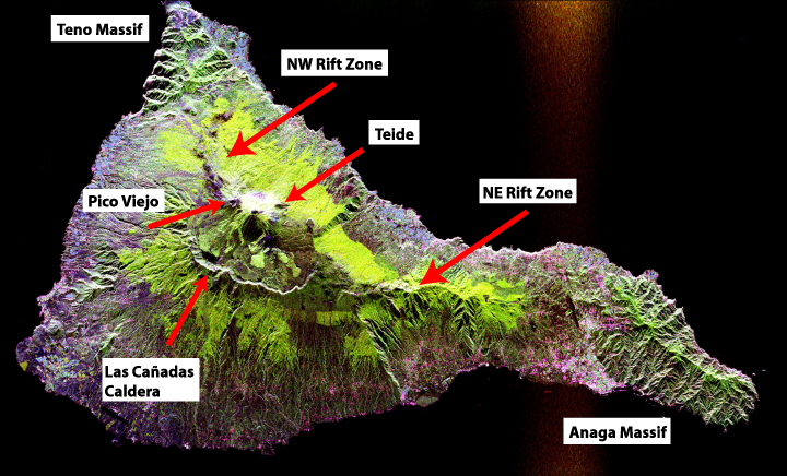
Edited from original file to add in geological labels (the Teide/Pico Viejo massif, rift zones, Miocence shield volcano massifs and the Las Cañadas Caldera)
Space radar image of Teide, taken in 1994. NASA's description:
- This radar image shows the Teide volcano on the island of Tenerife in the Canary Islands. The Canary Islands, part of Spain, are located in the eastern Atlantic Ocean off the coast of Morocco. Teide has erupted only once in the 20th Century, in 1909, but is considered a potentially threatening volcano due to its proximity to the city of Santa Cruz de Tenerife, shown in this image as the purple and white area on the lower right edge of the island. The summit crater of Teide, clearly visible in the left center of the image, contains lava flows of various ages and roughnesses that appear in shades of green and brown. Different vegetation zones, both natural and agricultural, are detected by the radar as areas of purple, green and yellow on the volcano's flanks. Scientists are using images such as this to understand the evolution of the structure of Teide, especially the formation of the summit caldera and the potential for collapse of the flanks. The volcano is one of 15 identified by scientists as potentially hazardous to local populations, as part of the international
- The image was acquired by the Spaceborne Imaging Radar-C/X-Band Synthetic Aperture Radar (SIR-C/X-SAR) onboard the space shuttle Endeavour on October 11, 1994. SIR-C/X-SAR, a joint mission of the German, Italian and the United States space agencies, is part of NASA's Mission to Planet Earth. The image is centered at 28.3 degrees North latitude and 16.6 degrees West longitude. North is toward the upper right. The area shown measures 90 kilometers by 54.5 kilometers (55.8 miles by 33.8 miles). The colors in the image are assigned to different frequencies and polarizations of the radar as follows: red is L-band horizontally transmitted, horizontally received; green is L-band horizontally transmitted, vertically received; blue is C-band horizontally transmitted, vertically received.
Taken from NASA's Visible Earth: [1]. Converted to JPEG.
授權條款
[編輯]
| 本作品由NASA創作,屬於公有領域。根據NASA的版權政策:“NASA的創作除非另有聲明否則不受版權保護。”(參見:Template:PD-USGov/zh,NASA版權政策或JPL圖像使用政策) | ||
 |
警告:
|
檔案歷史
點選日期/時間以檢視該時間的檔案版本。
| 日期/時間 | 縮圖 | 尺寸 | 用戶 | 備註 | |
|---|---|---|---|---|---|
| 目前 | 2007年10月12日 (五) 11:12 | | 720 × 436(431 KB) | ExtraFossiliferous(對話 | 貢獻) | Edited from original file to add in geological labels (the Teide/Pico Viejo massif, rift zones, Miocence shield volcano massifs and the Las Cañadas Caldera) Space radar image of Teide, taken in 1994. NASA's description: :This radar image shows the Teide |
無法覆蓋此檔案。
檔案用途
沒有使用此檔案的頁面。
全域檔案使用狀況
以下其他 wiki 使用了這個檔案:
- bg.wikipedia.org 的使用狀況
- da.wikipedia.org 的使用狀況
- en.wikipedia.org 的使用狀況
- fr.wikipedia.org 的使用狀況
- he.wikipedia.org 的使用狀況
- ja.wikipedia.org 的使用狀況
- mk.wikipedia.org 的使用狀況
- nn.wikipedia.org 的使用狀況
- pl.wikipedia.org 的使用狀況
- sl.wikipedia.org 的使用狀況
- zh.wikipedia.org 的使用狀況
分類:
- Satellite pictures of Tenerife
- Satellite pictures of Teide
- Radar images of Earth
- Satellite pictures of islands
- SIR-C/X-SAR
- Radar images of Teide
- Satellite pictures of volcanoes in Spain
- Maps of volcanoes in Spain
- Volcano monitoring in the Canary Islands
- Pico Viejo
- Topography of the Canary Islands
- Rift zones of volcanoes
- Topographic maps of Teide
- Altitudinal vegetation zones
- Geological maps of Tenerife