File:TOMS indonesia smog lrg.jpg
Изворна податотека (1.234 × 801 пиксели, големина: 337 КБ, MIME-тип: image/jpeg)
Описи
Описи
Опис
[уреди]
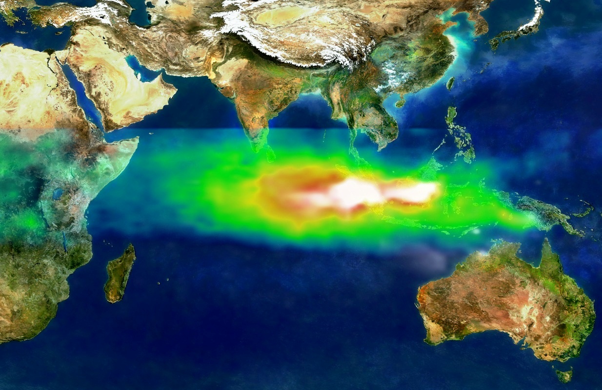
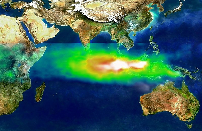
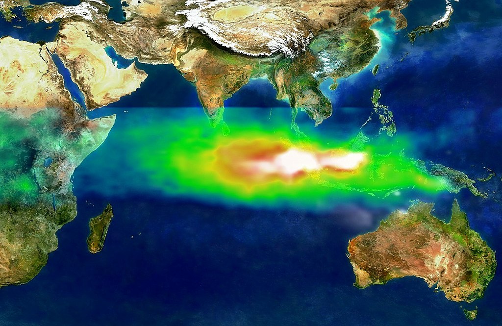
This image shows the pollution over Indonesia and the Indian Ocean on October 22, 1997. White represents the aerosols (smoke) that remained in the vicinity of the fires. Green, yellow, and red pixels represent increasing amounts of tropospheric ozone (smog) being carried to the west by high-altitude winds.
Researchers have discovered that smoke and smog move in different ways through the atmosphere. A series of unusual events several years ago created a blanket of pollution over the Indian Ocean.
In the second half of 1997, smoke from Indonesian fires remained stagnant over Southeast Asia while smog, which is tropospheric, low-level ozone, spread more rapidly across the Indian Ocean toward India.
Researchers tracked the pollution using data from NASA's Earth Probe Total Ozone Mapping Spectrometer (TOMS) satellite instrument. "TOMS is the only satellite instrument that follows both smoke and smog, globally," said Anne Thompson, NASA Earth Scientist at Goddard Space Flight Center, Greenbelt, MD. "The extreme pollution generated during the Indonesian fires was the first time we saw smoke move more slowly and in different directions from where smog moved."
http://visibleearth.nasa.gov/view_rec.php?id=1651
Лиценцирање
[уреди]
| Оваа податотека е во јавна сопственост бидејќи нејзин создавач е НАСА. Правилата за авторски права на НАСА велат: „Материјалот на НАСА не е заштитен со авторски права освен ако не е поинаку нагласено“. (Правилата за авторски дела на НАСА или правила за користење на слики од Лабораторијата за реактивен погон (JPL)). | ||
 |
Предупредувања:
|
Историја на податотеката
Стиснете на датум/време за да ја видите податотеката како изгледала тогаш.
| Датум/време | Минијатура | Димензии | Корисник | Коментар | |
|---|---|---|---|---|---|
| тековна | 10:18, 12 септември 2013 | | 1.234 × 801 (337 КБ) | Soerfm (разговор | придонеси) | Crop, contrast |
| 00:58, 8 септември 2005 |  | 1.280 × 960 (456 КБ) | SEWilco (разговор | придонеси) | This image shows the pollution over Indonesia and the Indian Ocean on October 22, 1997. White represents the aerosols (smoke) that remained in the vicinity of the fires. Green, yellow, and red pixels represent increasing amounts of tropospheric ozone (smo |
Не можете да презапишете врз податотекава.
Употреба на податотеката
Податотекава се користи во следниве 3 страници:
Глобална употреба на податотеката
Оваа податотека ја користат и следниве викија:
- Употреба на ar.wikipedia.org
- Употреба на cs.wikipedia.org
- Употреба на de.wikipedia.org
- Употреба на en.wikipedia.org
- Употреба на fi.wikipedia.org
- Употреба на fi.wikinews.org
- Употреба на fr.wikipedia.org
- Употреба на id.wikipedia.org
- Употреба на ig.wikipedia.org
- Употреба на it.wikipedia.org
- Употреба на mk.wikipedia.org
- Употреба на ms.wikipedia.org
- Употреба на ru.wikipedia.org
- Употреба на ru.wikinews.org
- Употреба на simple.wikipedia.org
- Употреба на sv.wikipedia.org
- Употреба на ta.wikipedia.org
- Употреба на uk.wikipedia.org
- Употреба на vi.wikipedia.org
- Употреба на zh.wikipedia.org