File:TS Bonnie 2004.jpg
跳转到导航
跳转到搜索

本预览的尺寸:600 × 600像素。 其他分辨率:240 × 240像素 | 480 × 480像素 | 768 × 768像素 | 1,024 × 1,024像素 | 2,048 × 2,048像素 | 6,000 × 6,000像素。
原始文件 (6,000 × 6,000像素,文件大小:6.81 MB,MIME类型:image/jpeg)
说明
说明
添加一行文字以描述该文件所表现的内容
摘要
[编辑]| 描述 |
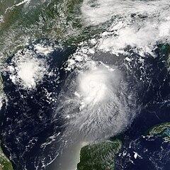
The MODIS instrument aboard NASA's Terra satellite captured this true-color image of Tropical Storm Bonnie on August 11 at 12:50 p.m. EDT. At the time this image was taken Bonnie had maximum sustained winds of 65 mph with an estimated minimum central pressure of 1000 millibars. Bonnie was expected to make landfall between Panama City and Apalachicola during the morning of August 12. The high-resolution image provided above has a spatial resolution of 1-square-kilometer per pixel. The MODIS Rapid Response System provides this image at additional resolutions and formats. |
|||||
| 日期 | ||||||
| 来源 | http://earthobservatory.nasa.gov/NaturalHazards/natural_hazards_v2.php3?img_id=12325 | |||||
| 作者 | Image courtesy Jacques Descloitres, MODIS Land Rapid Response Team at NASA GSFC. | |||||
| 授权 (二次使用本文件) |
|

文件历史
点击某个日期/时间查看对应时刻的文件。
| 日期/时间 | 缩略图 | 大小 | 用户 | 备注 | |
|---|---|---|---|---|---|
| 当前 | 2023年7月31日 (一) 05:57 | | 6,000 × 6,000(6.81 MB) | Nino Marakot(留言 | 贡献) | Reverted to version as of 21:42, 19 August 2006 (UTC) |
| 2023年7月2日 (日) 20:28 |  | 6,000 × 8,000(13.36 MB) | Sandy14156(留言 | 贡献) | worldview version; focused on the center of the storm | |
| 2006年8月19日 (六) 21:42 |  | 6,000 × 6,000(6.81 MB) | Good kitty(留言 | 贡献) | ||
| 2006年8月17日 (四) 18:49 |  | 3,000 × 3,000(2.85 MB) | Good kitty(留言 | 贡献) | {{Information |Description=The MODIS instrument aboard NASA's Terra satellite captured this true-color image of Tropical Storm Bonnie on August 11 at 12:50 p.m. EDT. At the time this image was taken Bonnie had maximum sustained winds of 65 mph with an est |
您不可以覆盖此文件。
文件用途
以下页面使用本文件:
全域文件用途
以下其他wiki使用此文件:
- de.wikipedia.org上的用途
- en.wikipedia.org上的用途
- Portal:Tropical cyclones/Featured article/Tropical Storm Bonnie (2004)
- Portal:Tropical cyclones/Did you know/Archive
- User:Wxtrackercody/2004 Atlantic hurricane season
- Wikipedia:Today's featured article/November 2017
- Wikipedia:Today's featured article/November 10, 2017
- Wikipedia:Main Page history/2017 November 10
- es.wikipedia.org上的用途
- fr.wikipedia.org上的用途
- pt.wikipedia.org上的用途
- ru.wikipedia.org上的用途
- simple.wikipedia.org上的用途
- si.wikipedia.org上的用途
- www.wikidata.org上的用途
- zh.wikipedia.org上的用途
- Portal:美國/特色條目
- 2004年大西洋颶風季
- Wikipedia:优良条目/2014年3月
- 2004年热带风暴邦尼
- Talk:2004年热带风暴邦尼
- Wikipedia:优良条目/2014年3月12日
- Wikipedia:优良条目/2004年热带风暴邦尼
- Wikipedia:典范条目/2014年2月
- Wikipedia:典范条目/2014年2月8日
- Wikipedia:典范条目/2004年热带风暴邦尼
- Portal:美國/特色條目/73
- Wikipedia:典范条目/2015年7月
- Wikipedia:典范条目/2015年7月13日
- Wikipedia:典范条目/2017年9月
- Wikipedia:典范条目/2017年9月15日
- Wikipedia:典范条目/2020年5月
- Wikipedia:典范条目/2020年5月16日