File:TWW mit Veränderung im VDC 2.jpg
Jump to navigation
Jump to search

Size of this preview: 800 × 467 pixels. Other resolutions: 320 × 187 pixels | 640 × 374 pixels | 955 × 558 pixels.
Original file (955 × 558 pixels, file size: 169 KB, MIME type: image/jpeg)
Captions
Captions
Add a one-line explanation of what this file represents
Summary
[edit]
| Description |
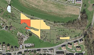
Deutsch: Beispiel des GIS-gestützten Früherkennungssystems. Es ermöglicht den Naturschutzbehörden des Bundes und der Kantone, negative Veränderungen zu erkennen und rechtzeitig Gegenmassnahmen zur Wiederherstellung der Lebensraumqualität einzuleiten. Hier eine Trockenwiese von nationaler Bedeutung, bei der Bereiche im Laufe der vergangenen Erhebungsperiode von sechs Jahren verbuscht sind. Im rot markierten Bereich hat die Gehölzdeckung zwischen 36 und 50 % zugenommen, in den gelben zwischen 5 und 20 % und in den hellblauen gab es eine Abnahme von >5%.
Français : Exemple du système de détection précoce basé sur le SIG. Il permet aux autorités de protection de la nature de la Confédération et des cantons de détecter les changements négatifs et de prendre à temps des contre-mesures pour rétablir la qualité de l'habitat. Ici, une prairie sèche d'importance nationale, dont certaines zones se sont embroussaillées au cours de la dernière période de relevé de six ans. Dans la zone marquée en rouge, la couverture arbustive a augmenté de 36 à 50 %, dans les zones jaunes de 5 à 20 % et dans les zones bleu clair, il y a eu une diminution de >5 %.
English: Example of the GIS-based early detection system. It enables the nature conservation authorities of the Confederation and the cantons to recognise negative changes and to initiate countermeasures in time to restore habitat quality. This is a dry grassland of national importance where areas have become overgrown in the course of the past six-year survey period. In the area marked red, the woody cover has increased between 36 and 50%, in the yellow between 5 and 20% and in the light blue there has been a decrease of >5%. |
| Date | |
| Source | Swisstopo; I received it from Ariel Bergamini who is leader of the project "Wirkungskontrolle Biotopschutz Schweiz" for the publication on the wikipedia page of the project |
| Author | Ariel Bergamini |
Licensing
[edit]
This file is licensed under the Creative Commons Attribution 4.0 International license.
- You are free:
- to share – to copy, distribute and transmit the work
- to remix – to adapt the work
- Under the following conditions:
- attribution – You must give appropriate credit, provide a link to the license, and indicate if changes were made. You may do so in any reasonable manner, but not in any way that suggests the licensor endorses you or your use.
File history
Click on a date/time to view the file as it appeared at that time.
| Date/Time | Thumbnail | Dimensions | User | Comment | |
|---|---|---|---|---|---|
| current | 07:56, 17 November 2022 | | 955 × 558 (169 KB) | Steffen Boch (talk | contribs) | Uploaded a work by Ariel Bergamini from I received it from Ariel Bergamini who is leader of the project "Wirkungskontrolle Biotopschutz Schweiz" for the publication on the wikipedia page of the project with UploadWizard |
You cannot overwrite this file.
File usage on Commons
There are no pages that use this file.
File usage on other wikis
The following other wikis use this file:
- Usage on de.wikipedia.org