File:Tabula itineris Israelitarum per desertum ab exitu de Aegypto ad usque vadu Jordanis (FL37128467 3911155).jpg
Jump to navigation
Jump to search

Size of this preview: 800 × 555 pixels. Other resolutions: 320 × 222 pixels | 640 × 444 pixels | 1,024 × 710 pixels | 1,280 × 888 pixels | 2,560 × 1,776 pixels | 4,998 × 3,467 pixels.
Original file (4,998 × 3,467 pixels, file size: 6.55 MB, MIME type: image/jpeg)
Captions
Captions
Add a one-line explanation of what this file represents
Summary
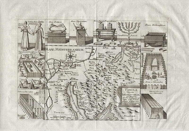
[edit]| Tabula itineris Israelitarum per desertum ab exitu de Aegypto ad usque vadu Jordanis
( |
||||||||||||||||||||||||
|---|---|---|---|---|---|---|---|---|---|---|---|---|---|---|---|---|---|---|---|---|---|---|---|---|
| Artist |
| |||||||||||||||||||||||
| Contributors | Liebaux, Jean Baptiste | |||||||||||||||||||||||
| Title |
Tabula itineris Israelitarum per desertum ab exitu de Aegypto ad usque vadu Jordanis |
|||||||||||||||||||||||
| Publisher |
publisher not identified |
|||||||||||||||||||||||
| Description |
Tabula itineris Israelitarum per desertum ab exitu de Aegypto ad usque vadu Jordanis. delineata ab Authore comentary in Exodum et incisa primu a Liebaux Geographo. |
|||||||||||||||||||||||
| Language | Latin | |||||||||||||||||||||||
| Publication date | 1797 possibly | |||||||||||||||||||||||
| Medium | 1 online resource (1 map). | |||||||||||||||||||||||
| Collection |
|
|||||||||||||||||||||||
| Current location |
|
|||||||||||||||||||||||
| Place of publication | France | |||||||||||||||||||||||
| search Merhav catalog | France | |||||||||||||||||||||||
| Notes | Digital image of the original in Amir Cahanovitc Collection, Israel. ACC 3115.; Digital image received from donor. | |||||||||||||||||||||||
| IE PID | IE37128465 | |||||||||||||||||||||||
| Rosetta filename | FL37128467 | |||||||||||||||||||||||
| NNL item ID (P3959) | 990039111550205171 | |||||||||||||||||||||||
| search Merhav catalog | Latin | |||||||||||||||||||||||
| search Merhav catalog | Exodus, TheMapspublisher not identified | |||||||||||||||||||||||
| Source/Photographer |
|
|||||||||||||||||||||||
| Other versions | ||||||||||||||||||||||||
| Jpg / Tif version |
|
|||||||||||||||||||||||

.jpg)

.jpg&action=edit§ion=1)
Licensing
[edit].jpg&action=edit§ion=2)
The copyright situation of this work is theoretically uncertain, because in the country of origin copyright lasts 70 years after the death of the author, and the date of the author's death is unknown. However, the date of creation of the work was over 120 years ago, and it is thus a reasonable assumption that the copyright has expired (see here for the community discussion). Do not use this template if the date of death of the author is known.
| |
| This file has been identified as being free of known restrictions under copyright law, including all related and neighboring rights. | |
File history
Click on a date/time to view the file as it appeared at that time.
| Date/Time | Thumbnail | Dimensions | User | Comment | |
|---|---|---|---|---|---|
| current | 19:09, 1 September 2023 | | 4,998 × 3,467 (6.55 MB) | Geagea (talk | contribs) | pattypan 22.03 |
You cannot overwrite this file.
File usage on Commons
The following page uses this file:
.jpg&oldid=797630926)