File:Taichung City Map by US Army.jpg
跳至導覽
跳至搜尋
預覽大小:450 × 599 像素。 其他解析度:180 × 240 像素 | 360 × 480 像素 | 577 × 768 像素 | 769 × 1,024 像素 | 1,538 × 2,048 像素 | 5,048 × 6,723 像素。
原始檔案 (5,048 × 6,723 像素,檔案大小:7.9 MB,MIME 類型:image/jpeg)
說明
說明
添加單行說明來描述出檔案所代表的內容
摘要
[編輯]
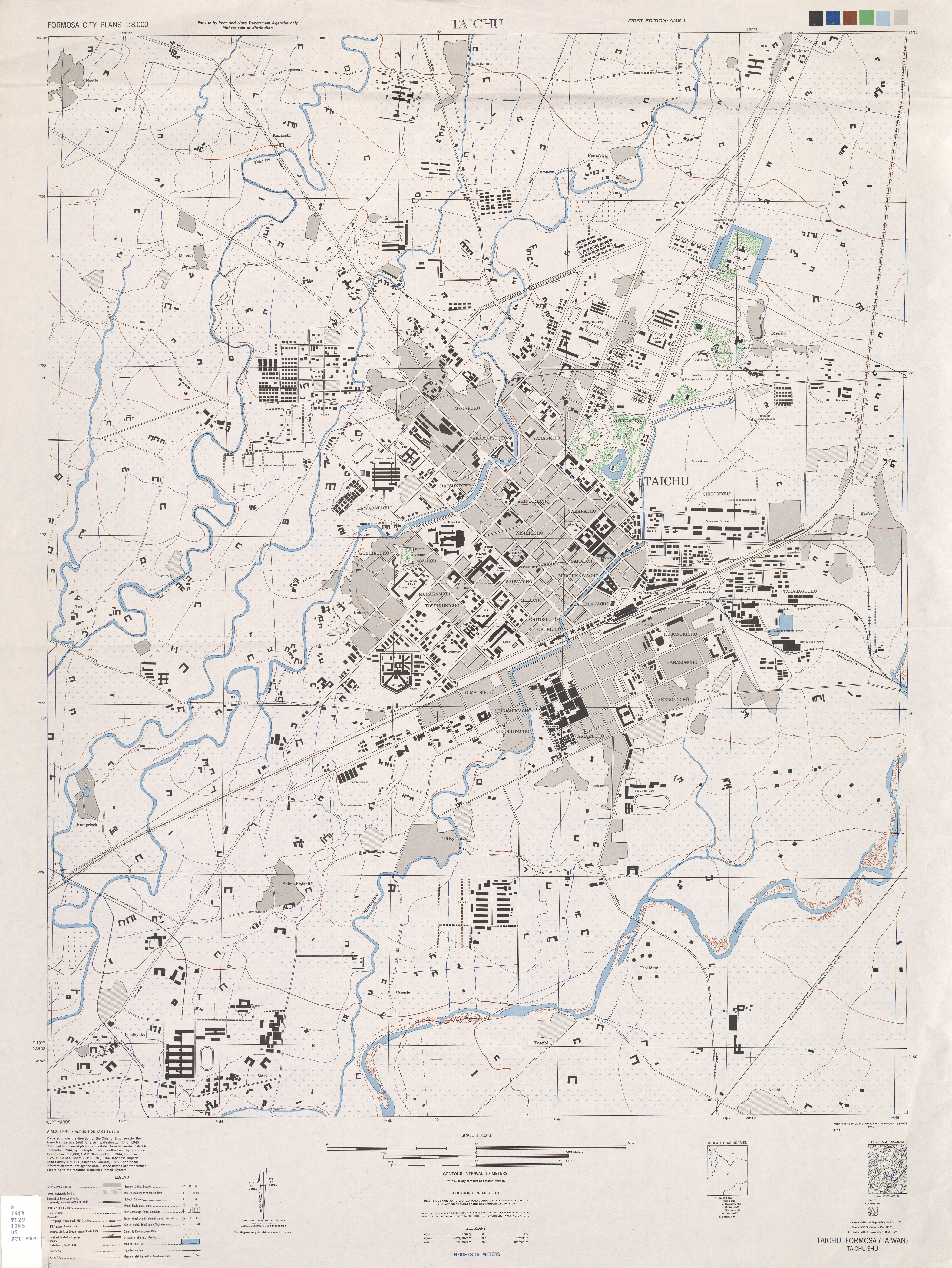
| 描述 | A map of Taichung City in 1940s. It's made by the U.S. Army./美軍於太平洋戰爭時期,所繪的台中市地圖。 |
| 日期 | 1944-1945 A.D. |
| 來源 | Original from http://www.lib.utexas.edu/maps/ams/formosa_city_plans/index.html(in the website of the University of Texas)/來自放在德州大學的,關於美軍測繪台灣城市之地圖的網頁,下載點:http://www.lib.utexas.edu/maps/ams/formosa_city_plans/index.html 。 |
| 作者 | the US Army |
授權條款
[編輯]
|
|
 |
檔案歷史
點選日期/時間以檢視該時間的檔案版本。
| 日期/時間 | 縮圖 | 尺寸 | 使用者 | 備註 | |
|---|---|---|---|---|---|
| 目前 | 2008年1月30日 (三) 14:16 | | 5,048 × 6,723(7.9 MB) | Yoxem(留言 | 貢獻) | {{Information |Description=A map of Taichung City in 1940s. It's made by the U.S. Army. |Source=Original from http://www.lib.utexas.edu/maps(the website of the university of Texas) |Date=1944-1945 A.D. |Author=the US Army |Permission=See below |other_vers |
無法覆蓋此檔案。
檔案用途
沒有使用此檔案的頁面。