File:Taiwan ROC political divisions labeled.svg
跳至導覽
跳至搜尋

此 SVG 檔案的 PNG 預覽的大小:425 × 600 像素。 其他解析度:170 × 240 像素 | 340 × 480 像素 | 544 × 768 像素 | 725 × 1,024 像素 | 1,451 × 2,048 像素 | 850 × 1,200 像素。
原始檔案 (SVG 檔案,表面大小:850 × 1,200 像素,檔案大小:343 KB)
說明
說明
添加單行說明來描述出檔案所代表的內容
| 描述 |
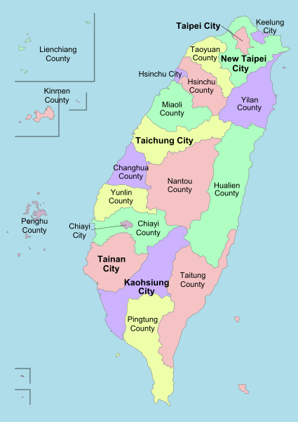
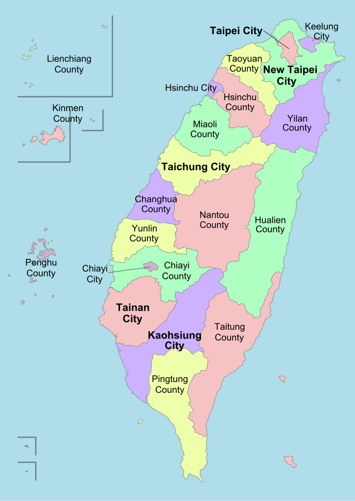
English: A political division map of Taiwan, ROC. |
| 日期 | (UTC) |
| 來源 | |
| 作者 |
|
| 其他版本 | 此檔案衍生的作品: Taiwan ROC political divisions labeled-ar.png |
| 這是一張修飾過的圖片,即本圖片是用軟體修改過後的版本,修改的方式或內容有:Labels。原版圖片來源:Taiwan ROC political division map.svg。修改者:Ran。
|
我,本作品的著作權持有者,決定用以下授權條款發佈本作品:
此檔案採用創用CC 姓名標示-相同方式分享 3.0 未在地化版本授權條款。
- 您可以自由:
- 分享 – 複製、發佈和傳播本作品
- 重新修改 – 創作演繹作品
- 惟需遵照下列條件:
- 姓名標示 – 您必須指名出正確的製作者,和提供授權條款的連結,以及表示是否有對內容上做出變更。您可以用任何合理的方式來行動,但不得以任何方式表明授權條款是對您許可或是由您所使用。
- 相同方式分享 – 如果您利用本素材進行再混合、轉換或創作,您必須基於如同原先的相同或兼容的條款,來分布您的貢獻成品。

|
已授權您依據自由軟體基金會發行的無固定段落、封面文字和封底文字GNU自由文件授權條款1.2版或任意後續版本,對本檔進行複製、傳播和/或修改。該協議的副本列在GNU自由文件授權條款中。 |
您可以選擇您需要的授權條款。
原始上傳日誌
[編輯]
This image is a derivative work of the following images:
- File:Taiwan_ROC_political_division_map.svg licensed with Cc-by-sa-3.0, GFDL
- 2008-08-02T18:04:11Z Luuva 850x1200 (165850 Bytes) {{Information |Description= |Source= |Date= |Author= |Permission= |other_versions={{DerivativeVersions|Taiwan ROC political divisions labeled-ar.png}} }}
- 2008-07-28T18:10:28Z Luuva 850x1200 (412965 Bytes) {{Information |Description= |Source= |Date= |Author= |Permission= |other_versions={{DerivativeVersions|Taiwan ROC political divisions labeled-ar.png}} }}
- 2008-07-26T22:03:59Z Luuva 850x1200 (403644 Bytes) {{Information |Description= |Source= |Date= |Author= |Permission= |other_versions={{DerivativeVersions|Taiwan ROC political divisions labeled-ar.png}} }}
- 2008-07-26T19:35:07Z Luuva 850x1200 (947187 Bytes) {{Information |Description= |Source= |Date= |Author= |Permission= |other_versions={{DerivativeVersions|Taiwan ROC political divisions labeled-ar.png}} }}
- 2008-07-26T19:29:40Z Luuva 850x1200 (942999 Bytes) {{Information |Description= |Source= |Date= |Author= |Permission= |other_versions={{DerivativeVersions|Taiwan ROC political divisions labeled-ar.png}} }}
- 2008-07-26T12:44:12Z Luuva 850x1200 (444811 Bytes) {{Information |Description= |Source= |Date= |Author= |Permission= |other_versions={{DerivativeVersions|Taiwan ROC political divisions labeled-ar.png}} }}
- 2008-07-26T12:41:58Z Luuva 850x1200 (444803 Bytes) {{Information |Description= |Source= |Date= |Author= |Permission= |other_versions={{DerivativeVersions|Taiwan ROC political divisions labeled-ar.png}} }}
- 2008-07-26T12:38:59Z Luuva 850x1200 (444770 Bytes) {{Information |Description={{en|1=A political division map of Taiwan, ROC.}} |Source=Own work by uploader |Author=[[User:Luuva|Luuva]] |Date=July 2008 |Permission= |other_versions={{DerivativeVersions|Taiwan ROC political divisions labeled-ar.png}} }} [[Category:SVG maps
Uploaded with derivativeFX
檔案歷史
點選日期/時間以檢視該時間的檔案版本。
| 日期/時間 | 縮圖 | 尺寸 | 使用者 | 備註 | |
|---|---|---|---|---|---|
| 目前 | 2013年1月27日 (日) 22:39 | | 850 × 1,200(343 KB) | AHCCCP(留言 | 貢獻) | Reverted to version as of 00:06, 22 September 2011 |
| 2012年4月1日 (日) 16:54 |  | 850 × 1,200(125 KB) | Kanguole(留言 | 貢獻) | labels as text | |
| 2011年9月22日 (四) 00:06 |  | 850 × 1,200(343 KB) | Energiya(留言 | 貢獻) | New style, minor change | |
| 2011年8月17日 (三) 10:50 |  | 850 × 1,200(124 KB) | Energiya(留言 | 貢獻) | minor corrections | |
| 2011年1月4日 (二) 06:00 |  | 850 × 1,200(117 KB) | Energiya(留言 | 貢獻) | 2010 Administrative division reform | |
| 2009年4月11日 (六) 19:26 |  | 850 × 1,200(157 KB) | Ran(留言 | 貢獻) | bigger labels | |
| 2009年4月11日 (六) 19:16 |  | 850 × 1,200(156 KB) | Ran(留言 | 貢獻) | {{Information |Description={{en|1=A political division map of Taiwan, ROC.}} |Source=*File:Taiwan_ROC_political_division_map.svg |Date=2009-04-11 20:15 (UTC) |Author=*File:Taiwan_ROC_political_division_map.svg: Luuva *derivative |
無法覆蓋此檔案。
檔案用途
下列3個頁面有用到此檔案:
全域檔案使用狀況
以下其他 wiki 使用了這個檔案:
- en.wikipedia.org 的使用狀況
- fi.wikipedia.org 的使用狀況
- fr.wiktionary.org 的使用狀況
- he.wikipedia.org 的使用狀況
- hu.wikipedia.org 的使用狀況
- hy.wikipedia.org 的使用狀況
- ko.wikipedia.org 的使用狀況
- lv.wikipedia.org 的使用狀況
- ml.wikipedia.org 的使用狀況
- my.wikipedia.org 的使用狀況
- pt.wikipedia.org 的使用狀況
- simple.wikipedia.org 的使用狀況
- tr.wikipedia.org 的使用狀況
- Taipei
- Penghu Adaları
- Tainan
- Şablon:Tayvan'ın özel şehirleri, ilçeleri ve il şehirleri
- Yeni Taipei
- Kaohsiung
- Tayçung
- Hsinchu
- Keelung
- Taoyuan, Tayvan
- Chiayi
- Changhua (ilçe)
- Tayvan'ın idari bölümleri
- Chiayi (ilçe)
- Hsinchu (ilçe)
- Hualien (ilçe)
- Miaoli (ilçe)
- Nantou (ilçe)
- Pingtung (ilçe)
- Taitung (ilçe)
- Yunlin (ilçe)
- Yilan (ilçe)
檢視此檔案的更多全域使用狀況。