File:Tangkak IC.svg
Jump to navigation
Jump to search

Size of this PNG preview of this SVG file: 800 × 524 pixels. Other resolutions: 320 × 209 pixels | 640 × 419 pixels | 1,024 × 670 pixels | 1,280 × 838 pixels | 2,560 × 1,676 pixels | 3,029 × 1,983 pixels.
Original file (SVG file, nominally 3,029 × 1,983 pixels, file size: 2.42 MB)
Captions
Captions
Add a one-line explanation of what this file represents
Summary[edit]
| Description |
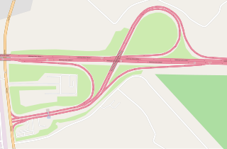
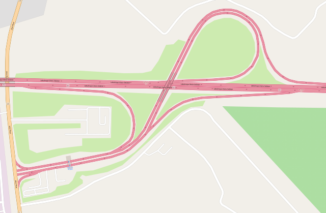
English: Map of Tangkak I/C, provided by openstreetmap.org. |
| Date | |
| Source | OpenStreetMap |
| Author | © OpenStreetMap contributors |
| Description |
This map was created from OpenStreetMap project data, collected by the community. This map may be incomplete, and may contain errors. Don't rely solely on it for navigation. |
|||
| Date | (see file history) | |||
| Source | openstreetmap.org | |||
| Creator |
OpenStreetMap contributors |
|||
| Permission (Reusing this file) |
OpenStreetMap data is available under the Open Database License (details). Standard style map tiles are licensed as ODbL Produced Works.
|
|||
| Georeferencing | If inappropriate please set warp_status = skip to hide. |
Licensing[edit]
| This work is licensed under the Open Database License (summary). |
File history
Click on a date/time to view the file as it appeared at that time.
| Date/Time | Thumbnail | Dimensions | User | Comment | |
|---|---|---|---|---|---|
| current | 07:25, 30 October 2020 | | 3,029 × 1,983 (2.42 MB) | *angys* (talk | contribs) | 2020 update |
| 05:15, 23 November 2018 |  | 3,259 × 1,785 (2.29 MB) | *angys* (talk | contribs) | User created page with UploadWizard |
You cannot overwrite this file.
File usage on Commons
There are no pages that use this file.
File usage on other wikis
The following other wikis use this file:
- Usage on zh.wikipedia.org