File:Tank farm.jpg
Jump to navigation
Jump to search

Size of this preview: 800 × 400 pixels. Other resolutions: 320 × 160 pixels | 640 × 320 pixels | 1,024 × 512 pixels | 1,280 × 640 pixels | 2,560 × 1,280 pixels | 17,310 × 8,655 pixels.
Original file (17,310 × 8,655 pixels, file size: 35.58 MB, MIME type: image/jpeg)
Captions
Captions
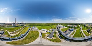
Tank farm in oil shale plant Enefit280
Summary
[edit]
| Warning | The original file is very high-resolution. It might not load properly or could cause your browser to freeze when opened at full size. |
|---|
| Description |
English: The tank farm is the final stop for oil output on the territory of Enefit Power. The medium oil and petrol fractions are stored in tanks. In the tank farm, it is possible to mix the medium oil and petrol fractions together to obtain a final product with properties suitable for the customer. There are both wagon and truck loading platforms in the tank farm. |
| Date | |
| Source | Own work |
| Author | Lauri Veerde |
| Camera location | | View this and other nearby images on: OpenStreetMap |
|---|
| 360° | View in 360° panoramic viewer
|
|---|
Licensing
[edit]
I, the copyright holder of this work, hereby publish it under the following license:
This file is licensed under the Creative Commons Attribution-Share Alike 4.0 International license.
- You are free:
- to share – to copy, distribute and transmit the work
- to remix – to adapt the work
- Under the following conditions:
- attribution – You must give appropriate credit, provide a link to the license, and indicate if changes were made. You may do so in any reasonable manner, but not in any way that suggests the licensor endorses you or your use.
- share alike – If you remix, transform, or build upon the material, you must distribute your contributions under the same or compatible license as the original.
File history
Click on a date/time to view the file as it appeared at that time.
| Date/Time | Thumbnail | Dimensions | User | Comment | |
|---|---|---|---|---|---|
| current | 11:52, 13 December 2021 | | 17,310 × 8,655 (35.58 MB) | Veerdelauri (talk | contribs) | Uploaded own work with UploadWizard |
You cannot overwrite this file.
File usage on Commons
There are no pages that use this file.