File:Tannenberg3008.jpg
Zur Navigation springen
Zur Suche springen
Größe dieser Vorschau: 775 × 600 Pixel. Weitere Auflösungen: 310 × 240 Pixel | 620 × 480 Pixel | 993 × 768 Pixel | 1.242 × 961 Pixel.
Originaldatei (1.242 × 961 Pixel, Dateigröße: 207 KB, MIME-Typ: image/jpeg)
Bildtexte
Kurzbeschreibungen
Ergänze eine einzeilige Erklärung, was diese Datei darstellt.

|
File:East Prussian Campaign (27—30 Aug 1914) - ru.svg ist eine vektorisierte Version dieses Bildes. Diese sollte an Stelle des Rasterbildes verwendet werden, sofern sie nicht schlechter ist.
File:Tannenberg3008.jpg → File:East Prussian Campaign (27—30 Aug 1914) - ru.svg
Für weitere Informationen siehe Help:SVG. |
_-_ru.svg) |
| Beschreibung |
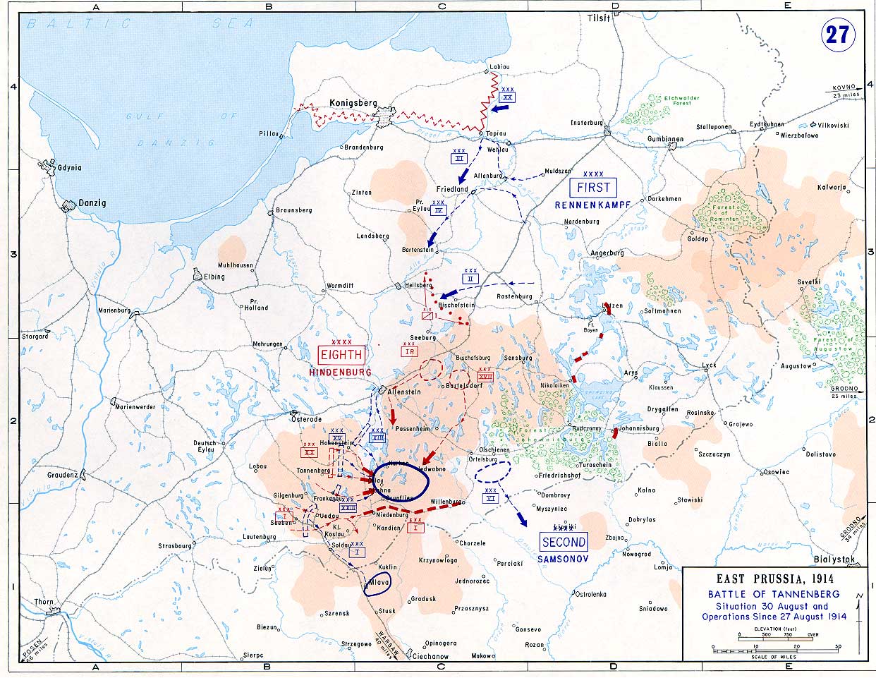
English: Battle of Tannenberg (1914) in its last phase |
| Quelle |
Taken from the campaign series, made public by the US-Army under dean.usma.edu
|
| Urheber | US-Army under www.dean.usma.edu |
| Genehmigung (Weiternutzung dieser Datei) |
The picture is public domain. |
| Openstreetmap entry | Verweis zu OpenStreetMap |
| Objektposition | | Dieses und weitere Bilder auf OpenStreetMap |
|---|
Dieses Bild wurde von einem Mitglied der United States Army während der Ausführung seiner Dienstpflichten erstellt. Als eine Arbeit der Bundesregierung der Vereinigten Staaten ist dieses Bild in public domain.
|
 |
Dateiversionen
Klicke auf einen Zeitpunkt, um diese Version zu laden.
| Version vom | Vorschaubild | Maße | Benutzer | Kommentar | |
|---|---|---|---|---|---|
| aktuell | 14:29, 22. Sep. 2005 | | 1.242 × 961 (207 KB) | Nasiruddin (Diskussion | Beiträge) | Taken from the campaign series, made public by the US-Army under www.dean.usma.edu The öpicture is public domain. It shows the battle of Tannenberg in its last phase {{PD-USGov-Military-Army}} Category:World War I maps |
Du kannst diese Datei nicht überschreiben.
Dateiverwendung
Die folgenden 3 Seiten verwenden diese Datei:
Globale Dateiverwendung
Die nachfolgenden anderen Wikis verwenden diese Datei:
- Verwendung auf be-tarask.wikipedia.org
- Verwendung auf be.wikipedia.org
- Verwendung auf ca.wikipedia.org
- Verwendung auf cs.wikipedia.org
- Verwendung auf da.wikipedia.org
- Verwendung auf de.wikipedia.org
- Verwendung auf el.wikipedia.org
- Verwendung auf en.wikipedia.org
- Verwendung auf et.wikipedia.org
- Verwendung auf fi.wikipedia.org
- Verwendung auf fr.wikipedia.org
- Verwendung auf he.wikipedia.org
- Verwendung auf hr.wikipedia.org
- Verwendung auf it.wikipedia.org
- Verwendung auf ja.wikipedia.org
- Verwendung auf ko.wikipedia.org
- Verwendung auf lv.wikipedia.org
- Verwendung auf nl.wikipedia.org
- Verwendung auf no.wikipedia.org
- Verwendung auf pl.wikipedia.org
- Verwendung auf sv.wikipedia.org
- Verwendung auf uk.wikipedia.org
- Verwendung auf vi.wikipedia.org
- Verwendung auf zh.wikipedia.org