File:Tarawera Bathymetry.png
Jump to navigation
Jump to search

Size of this preview: 715 × 600 pixels. Other resolutions: 286 × 240 pixels | 572 × 480 pixels | 915 × 768 pixels | 1,220 × 1,024 pixels | 1,616 × 1,356 pixels.
Original file (1,616 × 1,356 pixels, file size: 4.05 MB, MIME type: image/png)
Captions
Captions
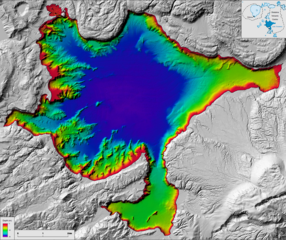
Bathymetric map of Lake Tarawera by GNS Science
Summary[edit]
| Description |
English: Bathymetric map of Lake Tarawera, one of the Rotorua Lakes. Shows lake floor features including prominent ridges that strike into the lake from the west and southwest and the extension of lava flows from Mt. Tarawera in the southeast and the large lava domes in the north into the lake. The centre of the lake is largely flat while pockmarks locally dot the margins of the lake, representing gas discharge.
Bibliographic reference de Ronde C.E.J.1, Caratori Tontini F.1,2, Black, J.A.1. 2022. Bathymetric Map of Lake Tarawera, New Zealand. Lower Hutt (NZ): GNS Science. Scale 1:19,000. (GNS Science Rotorua Lakes map series). DOI: 10.21420/3C7C-VY17. ISBN: 978-1-99-101396-5 1. Institute of Geological and Nuclear Sciences Ltd., Lower Hutt, New Zealand. 2. Università degli Studi di Genova, Genova, Italy |
| Date | |
| Source | https://shop.gns.cri.nz/rl-tarawera/ |
| Author | de Ronde C.E.J., Caratori Tontini F., Black, J.A. |
Licensing[edit]
This file is licensed under the Creative Commons Attribution-Share Alike 3.0 Unported license.
- You are free:
- to share – to copy, distribute and transmit the work
- to remix – to adapt the work
- Under the following conditions:
- attribution – You must give appropriate credit, provide a link to the license, and indicate if changes were made. You may do so in any reasonable manner, but not in any way that suggests the licensor endorses you or your use.
- share alike – If you remix, transform, or build upon the material, you must distribute your contributions under the same or compatible license as the original.
File history
Click on a date/time to view the file as it appeared at that time.
| Date/Time | Thumbnail | Dimensions | User | Comment | |
|---|---|---|---|---|---|
| current | 07:28, 31 August 2023 | | 1,616 × 1,356 (4.05 MB) | Turnagra (talk | contribs) | Uploaded a work by de Ronde C.E.J., Caratori Tontini F., Black, J.A. from https://shop.gns.cri.nz/rl-tarawera/ with UploadWizard |
You cannot overwrite this file.
File usage on Commons
There are no pages that use this file.
File usage on other wikis
The following other wikis use this file:
- Usage on en.wikipedia.org