File:Taupo.Volcanic.Zone.North.Island.NZ.JPG
Archivo original (616 × 864 píxeles; tamaño de archivo: 104 kB; tipo MIME: image/jpeg)
Leyendas
Leyendas
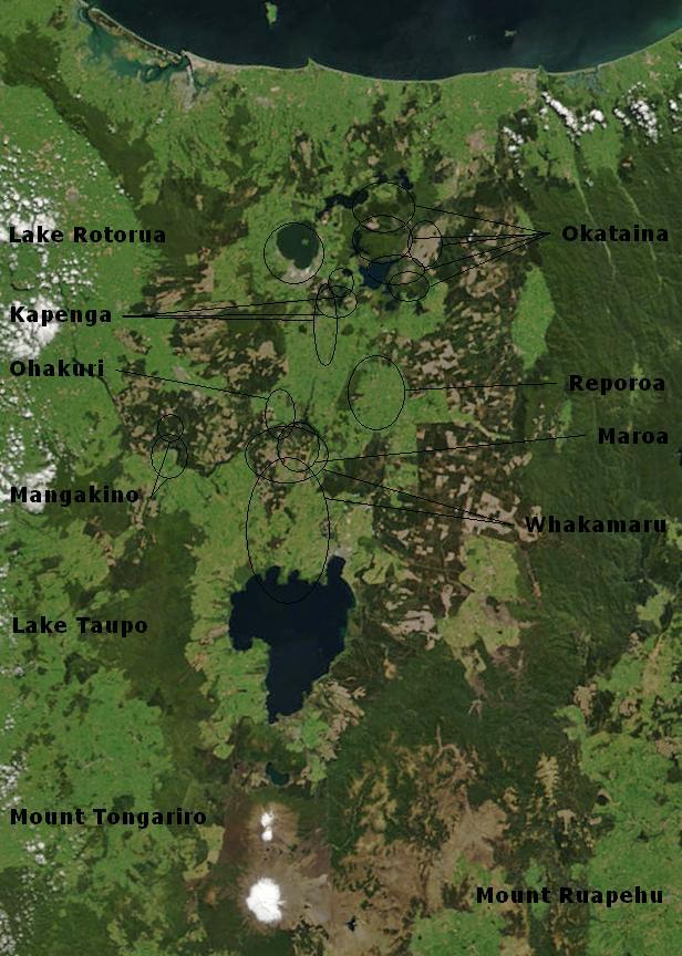
| Descripción | Bay of Plenty, North Island, New Zealand, from the Bay of Plenty coast to Mounts Tongariro, Ngauruhoe, and Ruapehu (at bottom of picture). Also shows Lake Taupo and the Rotorua Lakes. This scene was acquired by the Moderate Resolution Imaging Spectroradiometer (MODIS), flying aboard NASA’s Terra satellite, on October 23, 2002 |
| Fecha | (UTC) |
| Fuente | |
| Autor |
|
Annotations based on: Hiess J, Cole JW, Spinks KD (2007), High-Alumina Basalts of the Taupo Volcanic Zone, New Zealand: Influence of the Crust and Crustal Structure [1]; Krippner SJP, Briggs RM, Wilson CJN, Cole JW (1998), Petrography and geochemistry of lithic fragments in ignimbrites from the Mangakino Volcanic Centre: implications for the composition of the subvolcanic crust in western Taupo Volcanic Zone, New Zealand; New Zealand Journal of Geology and Geophysics, Vol. 41: 187-199 [2] archive copy at the Wayback Machine; Newhall, Christopher G.; Dzurisin, Daniel (1988), Historical unrest at large calderas of the world, USGS Bulletin 1855, p. 1108 [3] archive copy at the Wayback Machine; Siebert L, Simkin T (2002-), Volcanoes of the World: an Illustrated Catalog of Holocene Volcanoes and their Eruptions, Smithsonian Institution, Global Volcanism Program Digital Information Series, GVP-3 [4] archive copy at the Wayback Machine
| Este archivo es de dominio público porque fue creado por la NASA. Las políticas sobre copyright de la NASA estipulan que «el material de la NASA no está protegido con copyright a menos que se indique lo contrario». (Políticas sobre copyright de la NASA o Políticas sobre la utilización de imágenes del Jet Propulsion Laboratory). | ||
 |
Advertencias:
|
Registro original de carga
[editar]
This image is a derivative work of the following images:
- File:BayofPlentyA2002296.jpg licensed with PD-USGov-NASA
- 2007-08-24T00:20:45Z Kahuroa 616x864 (505144 Bytes) == Summary == {{Information |Description=Bay of Plenty, North Island, New Zealand, from the Bay of Plenty coast to Mounts Tongariro, Ngauruhoe, and Ruapehu (at bottom of picture). Also shows Lake Taupo and the Rotorua Lakes.
Uploaded with derivativeFX
Historial del archivo
Haz clic sobre una fecha y hora para ver el archivo tal como apareció en ese momento.
| Fecha y hora | Miniatura | Dimensiones | Usuario | Comentario | |
|---|---|---|---|---|---|
| actual | 02:17 20 feb 2010 | | 616 × 864 (104 kB) | Chris.urs-o (discusión | contribs.) | One label was missing. |
| 01:49 20 feb 2010 |  | 616 × 864 (103 kB) | Chris.urs-o (discusión | contribs.) | Fixed label | |
| 10:42 19 feb 2010 |  | 616 × 864 (105 kB) | Chris.urs-o (discusión | contribs.) | Improved caldera locations | |
| 11:20 18 feb 2010 |  | 616 × 864 (103 kB) | Chris.urs-o (discusión | contribs.) | {{Information |Description=Bay of Plenty, North Island, New Zealand, from the Bay of Plenty coast to Mounts Tongariro, Ngauruhoe, and Ruapehu (at bottom of picture). Also shows Lake Taupo and the Rotorua Lakes. This scene was acquired by the Moderate Reso |
No puedes sobrescribir este archivo.
Usos del archivo
No hay páginas que enlacen a este archivo.
Uso global del archivo
Las wikis siguientes utilizan este archivo:
- Uso en ar.wikipedia.org
- Uso en de.wikipedia.org
- Uso en en.wikipedia.org
- Uso en en.wikiversity.org
- Uso en es.wikipedia.org
- Uso en fi.wikipedia.org
- Uso en id.wikipedia.org
- Uso en it.wikipedia.org
- Uso en mk.wikipedia.org
- Uso en ru.wikipedia.org
- Uso en simple.wikipedia.org
- Uso en sl.wikipedia.org
- Uso en uk.wikipedia.org
Metadatos
- Taupo Volcanic Zone
- Satellite pictures of the Bay of Plenty Region
- Satellite pictures of the Manawatū-Whanganui Region
- Maps of volcanic zones
- Maps of calderas in New Zealand
- Satellite pictures of the Waikato Region
- Mangakino Caldera
- Lake Rotorua
- Lake Taupō
- Mount Tongariro
- Maps of Mount Ruapehu
- Maps of volcanoes in New Zealand
- Volcanoes in New Zealand in 2002
- Maps of Tongariro Volcanic Complex
- Satellite pictures of the Taupo Volcanic Zone