File:Tectonic map Mediterranean EN.svg
跳至導覽
跳至搜尋

此 SVG 檔案的 PNG 預覽的大小:800 × 447 像素。 其他解析度:320 × 179 像素 | 640 × 358 像素 | 1,024 × 572 像素 | 1,280 × 715 像素 | 2,560 × 1,430 像素。
原始檔案 (SVG 檔案,表面大小:1,280 × 715 像素,檔案大小:623 KB)
說明
說明
添加單行說明來描述出檔案所代表的內容
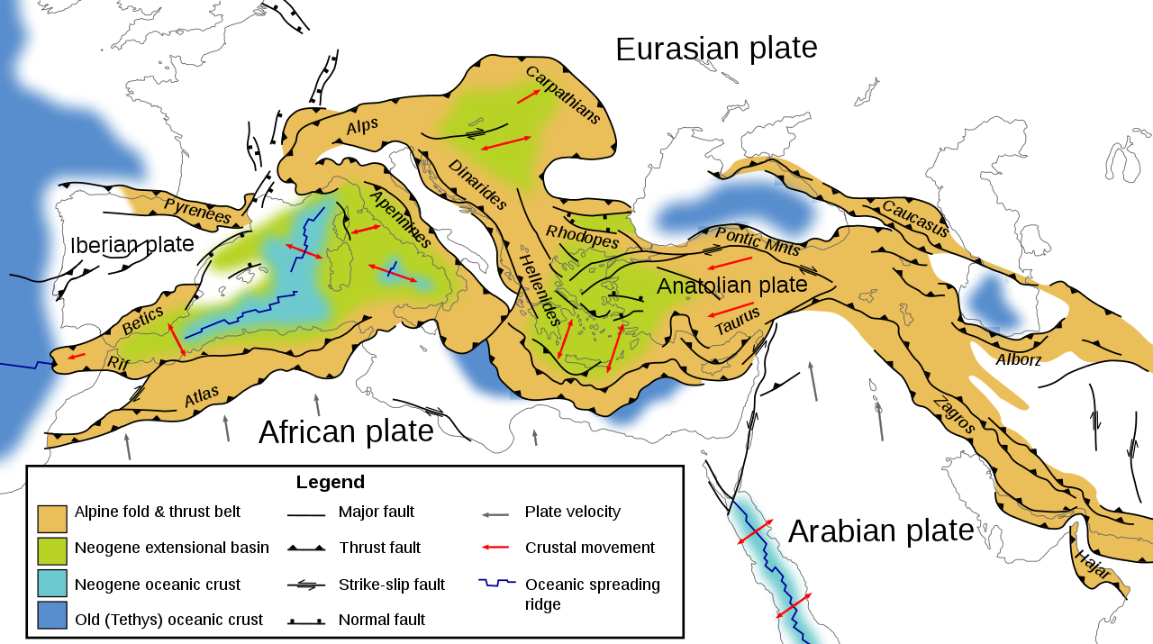
Tectonic map of southern Europe, North Africa and the Middle East
摘要
[編輯]| 描述 |
English: Tectonic map of southern Europe, North Africa and the Middle East, showing tectonic structures of the western Alpide mountain belt. Only Alpine (tertiary) structures are shown. |
| 日期 | |
| 來源 | 自己的作品 |
| 作者 | Woudloper |
| 其他版本 |
[]
|


|
This SVG file contains embedded text that can be translated into your language, using any capable SVG editor, text editor or the SVG Translate tool. For more information see: About translating SVG files. |
授權條款
[編輯]
此檔案採用創用CC 姓名標示-相同方式分享 1.0 通用版授權條款。
- 您可以自由:
- 分享 – 複製、發佈和傳播本作品
- 重新修改 – 創作演繹作品
- 惟需遵照下列條件:
- 姓名標示 – 您必須指名出正確的製作者,和提供授權條款的連結,以及表示是否有對內容上做出變更。您可以用任何合理的方式來行動,但不得以任何方式表明授權條款是對您許可或是由您所使用。
- 相同方式分享 – If you alter, transform, or build upon this work, you must distribute the resulting work under the same license as the original.
檔案歷史
點選日期/時間以檢視該時間的檔案版本。
| 日期/時間 | 縮圖 | 尺寸 | 使用者 | 備註 | |
|---|---|---|---|---|---|
| 目前 | 2009年6月9日 (二) 16:07 | | 1,280 × 715(623 KB) | Woudloper(留言 | 貢獻) | removed shade behind strik-slip symbols |
| 2009年6月9日 (二) 15:19 |  | 1,280 × 715(625 KB) | Woudloper(留言 | 貢獻) | {{Information |Description={{en|1=Tectonic map of southern Europe and the Middle East, showing tectonic structures of the western Alpide mountain belt. Only Alpine (Tertiary) structures are shown.}} |Source=Eigen |
無法覆蓋此檔案。
檔案用途
下列13個頁面有用到此檔案:
- Atlas Mountains
- User:Woudloper
- File:Tectonic map Mediterranean DE.svg
- File:Tectonic map Mediterranean EN.svg
- File:Tectonic map Mediterranean FR.svg
- File:Tectonic map Mediterranean He.jpg
- File:Tectonic map Mediterranean IT.svg
- File:Tectonic map Mediterranean MK.svg
- File:Tectonic map Mediterranean NL.svg
- File:Tectonic map Mediterranean UK.svg
- File:Tectonic map Mediterranean es.svg
- Template:Other versions/Tectonic map Mediterranean
- Category:Alpine orogeny
全域檔案使用狀況
以下其他 wiki 使用了這個檔案:
- ar.wikipedia.org 的使用狀況
- az.wikipedia.org 的使用狀況
- ba.wikipedia.org 的使用狀況
- be.wikipedia.org 的使用狀況
- cs.wikipedia.org 的使用狀況
- de.wikipedia.org 的使用狀況
- en.wikipedia.org 的使用狀況
- fa.wikipedia.org 的使用狀況
- gl.wikipedia.org 的使用狀況
- hr.wikipedia.org 的使用狀況
- hu.wikipedia.org 的使用狀況
- id.wikipedia.org 的使用狀況
- ja.wikipedia.org 的使用狀況
- ja.wikibooks.org 的使用狀況
- ka.wikipedia.org 的使用狀況
- ko.wikipedia.org 的使用狀況
- ku.wikipedia.org 的使用狀況
- ml.wikipedia.org 的使用狀況
- nn.wikipedia.org 的使用狀況
- no.wikipedia.org 的使用狀況
- ro.wikipedia.org 的使用狀況
- ru.wikipedia.org 的使用狀況
- sh.wikipedia.org 的使用狀況
- simple.wikipedia.org 的使用狀況
- sk.wikipedia.org 的使用狀況
- tr.wikipedia.org 的使用狀況
- uk.wikipedia.org 的使用狀況
- vi.wikipedia.org 的使用狀況
- www.wikidata.org 的使用狀況
- zh.wikipedia.org 的使用狀況
分類:
- English-language SVG maps
- SVG geology
- Alpine orogeny
- Atlas Mountains
- Cordilleras Béticas
- Maps of Rhodope
- Maps of Anatolia
- Taurus Mountains
- Maps of the Caucasus
- Armenian Highland
- Maps of the Zagros Mountains
- Maps of the Alborz
- Geological maps of Europe
- Geological maps of Spain
- Geological maps of France
- Geological maps of the Alps
- Geological maps of the Dinaric Alps
- Maps of the Carpathian Mountains
- SVG maps of Turkey
- SVG maps of the Middle East
- Tectonics maps
- Geological maps of the Mediterranean Sea
- Geology of Morocco
- Geological maps of Morocco
- Structural geology of Turkey
- Structural geology of Italy
- Structural geology of France
- Structural geology of Spain
- Structural geology of Greece
- Geology of the Persian Gulf
- Hellenic Trench
- Alpide belt
- Geology of the Mediterranean Sea
- Neogene geology
- Neogene geology of Italy
- Neogene geology of Spain
- Neogene geology of Europe
- Neogene geology of Asia
- Iberian tectonic plate
- Geological maps of Iraq