File:Tectonic plates around Japan.png
Jump to navigation
Jump to search
No higher resolution available.
Tectonic_plates_around_Japan.png (500 × 500 pixels, file size: 77 KB, MIME type: image/png)
Captions
Captions
Add a one-line explanation of what this file represents
Summary[edit]
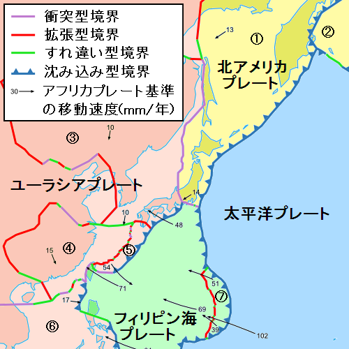
| Description | Map of Japan with tectonic plates. |
| Source | Image:Tectonic plates boundaries detailed-en.svg |
| Author | Pekachu |
- 日本語
- プレート(w:ja:プレートテクトニクス)の説明つき日本周辺の地図。
- ユーラシアプレート(ピンク)、北アメリカプレート(黄)、太平洋プレート(青)、フィリピン海プレート(緑)の4つの主要プレートについて色分けした。
- プレートのさらに細かい区分については、図中の番号で区分している。その番号とプレートの名称の対応関係は以下のとおり。
- 1:オホーツクプレート
- 2:ベーリングプレート
- 3:アムールプレート
- 4:揚子江プレート
- 5:沖縄プレート
- 6:スンダプレート
- 7:マリアナプレート
Licensing[edit]
This file is licensed under the Creative Commons Attribution-Share Alike 2.5 Generic license.
- You are free:
- to share – to copy, distribute and transmit the work
- to remix – to adapt the work
- Under the following conditions:
- attribution – You must give appropriate credit, provide a link to the license, and indicate if changes were made. You may do so in any reasonable manner, but not in any way that suggests the licensor endorses you or your use.
- share alike – If you remix, transform, or build upon the material, you must distribute your contributions under the same or compatible license as the original.
File history
Click on a date/time to view the file as it appeared at that time.
| Date/Time | Thumbnail | Dimensions | User | Comment | |
|---|---|---|---|---|---|
| current | 08:24, 6 May 2008 | | 500 × 500 (77 KB) | Pekachu (talk | contribs) | {{Information |Description=Map of Japan with tectonic plates. |Source=Image:Tectonic plates boundaries detailed-en.svg |Date= |Author=Pekachu |Permission= |other_versions= }} ;日本語: *プレート(w:ja:プレートテクトニクス)の� |
You cannot overwrite this file.
File usage on Commons
There are no pages that use this file.
File usage on other wikis
The following other wikis use this file:
- Usage on ja.wikipedia.org
- Usage on zh.wikipedia.org