File:Tectonic plates boundaries detailed-en.svg
跳至導覽
跳至搜尋

此 SVG 檔案的 PNG 預覽的大小:800 × 402 像素。 其他解析度:320 × 161 像素 | 640 × 322 像素 | 1,024 × 515 像素 | 1,280 × 643 像素 | 2,560 × 1,286 像素 | 4,898 × 2,461 像素。
原始檔案 (SVG 檔案,表面大小:4,898 × 2,461 像素,檔案大小:1.23 MB)
說明
說明
添加單行說明來描述出檔案所代表的內容
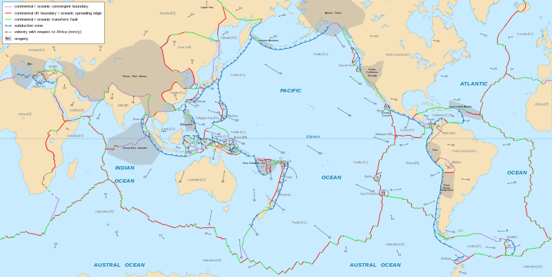
詳細的中文世界板塊地圖顯示板塊構造及其運動向量
摘要[編輯]
| 描述 |
English: Detailed world map in English showing the tectonic plates with their movement vectors
Français : Carte détaillée en anglais des plaques tectoniques avec leurs vecteurs de déplacement
Español: Mapa detallado en inglés que muestra las placas tectónicas con sus vectores de movimiento |
||
| 日期 | 2006-10, updated 2015-09 | ||
| 來源 |
|
||
| 作者 | Eric Gaba (Sting - fr:Sting) | ||
| 授權許可 (重用此檔案) |
|
||
| 其他版本 |
Derivative works of this file: Philippine Sea Plate br.JPG
|


.svg)


|
This SVG file contains embedded text that can be translated into your language, using any capable SVG editor, text editor or the SVG Translate tool. For more information see: About translating SVG files. |
授權條款[編輯]
我,本作品的著作權持有者,決定用以下授權條款發佈本作品:
此檔案採用創用CC 姓名標示-相同方式分享 2.5 通用版授權條款。
- 您可以自由:
- 分享 – 複製、發佈和傳播本作品
- 重新修改 – 創作演繹作品
- 惟需遵照下列條件:
- 姓名標示 – 您必須指名出正確的製作者,和提供授權條款的連結,以及表示是否有對內容上做出變更。您可以用任何合理的方式來行動,但不得以任何方式表明授權條款是對您許可或是由您所使用。
- 相同方式分享 – 如果您利用本素材進行再混合、轉換或創作,您必須基於如同原先的相同或兼容的條款,來分布您的貢獻成品。
檔案歷史
點選日期/時間以檢視該時間的檔案版本。
| 日期/時間 | 縮圖 | 尺寸 | 用戶 | 備註 | |
|---|---|---|---|---|---|
| 目前 | 2023年2月9日 (四) 16:29 | | 4,898 × 2,461(1.23 MB) | Roxy(對話 | 貢獻) | File uploaded using svgtranslate tool (https://svgtranslate.toolforge.org/). Added translation for tr. |
| 2018年1月25日 (四) 21:48 |  | 4,898 × 2,461(1.14 MB) | Sting(對話 | 貢獻) | Corrections on subduction directions | |
| 2018年1月15日 (一) 22:11 |  | 4,898 × 2,461(1.14 MB) | Sting(對話 | 貢獻) | Panama plate name | |
| 2015年9月6日 (日) 18:08 |  | 4,898 × 2,461(1.14 MB) | Sting(對話 | 貢獻) | Equator line correction | |
| 2015年9月6日 (日) 18:04 |  | 4,898 × 2,461(1.14 MB) | Sting(對話 | 貢獻) | Frame removed | |
| 2015年9月6日 (日) 17:38 |  | 4,898 × 2,461(1.14 MB) | Sting(對話 | 貢獻) | Shetland microplate direction added | |
| 2015年9月6日 (日) 17:28 |  | 4,898 × 2,461(1.14 MB) | Sting(對話 | 貢獻) | New background map using NGDC WCL data | |
| 2015年5月10日 (日) 07:50 |  | 4,898 × 2,472(843 KB) | 白布飘扬(對話 | 貢獻) | Shetland microplate: base on the original source, the movement speed is unclear but the direction is there. | |
| 2013年10月1日 (二) 17:21 |  | 4,898 × 2,472(841 KB) | Sting(對話 | 貢獻) | Shetland microplate: movement undefined => deleting the arrow | |
| 2012年9月6日 (四) 15:52 |  | 4,898 × 2,472(842 KB) | McZusatz(對話 | 貢獻) | typo corr. |
無法覆蓋此檔案。
檔案用途
下列22個頁面有用到此檔案:
- File:Arabian Plate map-uni.png
- File:AustralianPlate.png
- File:Caribbean plate tectonics-en.png
- File:Earthquake Information for Pakistan-es.svg
- File:Legend plate tectonic maps-en.png
- File:Legend plate tectonic maps-nl.png
- File:Scotia Plate map-en.png
- File:Tectonic plates boundaries World map Wt 10degE centered-en.svg
- File:Tectonic plates boundaries World map Wt 10degE centered-fr.svg
- File:Tectonic plates boundaries World map Wt 180degE centered-en.svg
- File:Tectonic plates boundaries World map Wt 180degE centered-fr.svg
- File:Tectonic plates boundaries detailed-en-2.svg (檔案重新導向)
- File:Tectonic plates boundaries detailed-en.png (檔案重新導向)
- File:Tectonic plates boundaries detailed-fr.svg
- File:Tectonic plates boundaries detailed-sr.png
- File:Tectonic plates boundaries detailed-su.svg
- File:Tectonic plates boundaries physical World map Wt 10degE centered-en.svg
- File:Tectonic plates boundaries physical World map Wt 10degE centered-fr.svg
- File:Tectonic plates boundaries physical World map Wt 180degE centered-en.svg
- File:Tectonic plates boundaries physical World map Wt 180degE centered-fr.svg
- Template:Other versions/Tectonic plates boundaries World map Winkel tripel projection
全域檔案使用狀況
以下其他 wiki 使用了這個檔案:
- ar.wikipedia.org 的使用狀況
- الصفائح التكتونية
- صفيحة المحيط الهادي
- صفيحة أمريكا الشمالية
- جزر غالاباغوس
- الصفيحة العربية
- صفيحة أوراسية
- الصفيحة الإفريقية
- حيد المحيط الهادئ والقطب الجنوبي
- حيد جنوب غرب المحيط الهندي
- حيد وسط المحيط الهندي
- ارتفاع شرق المحيط الهادئ
- حيد جاكل
- حيد وسط المحيط الأطلسي
- صفيحة خوان دو فوكا
- صفيحة هندية
- صفيحة هندية أسترالية
- صفيحة أمريكا الجنوبية
- صفيحة تونجا
- صفيحة نازكا
- قالب:الصفائح التكتونية
- صفيحة الفلبين
- صفيحة الكاريبي
- الصفيحة القطبية الجنوبية
- الصفيحة الصومالية
- صفيحة كوكوس
- نيكولاي كنيبوفيتش
- قائمة الصفائح التكتونية
- النقطة الساخنة غالاباغوس
- الصفيحة الأناضولية
- صفيحة لاسا
- مستخدم:Nehaoua/ملعب13
- القوس القبرصي
- القوس الهيليني
- الصفيحة الأسترالية
- صفيحة بورما
- صفيحة فيكتوريا الصغيرة
- az.wikipedia.org 的使用狀況
檢視此檔案的更多全域使用狀況。