File:Teilnehmer European Sky Shield 2024-2.png
Ir a la navegación
Ir a la búsqueda
Tamaño de esta previsualización: 694 × 599 píxeles. Otras resoluciones: 278 × 240 píxeles | 556 × 480 píxeles | 889 × 768 píxeles | 1186 × 1024 píxeles | 2371 × 2048 píxeles | 2942 × 2541 píxeles.
Archivo original (2942 × 2541 píxeles; tamaño de archivo: 542 kB; tipo MIME: image/png)
Leyendas
Leyendas
Añade una explicación corta acerca de lo que representa este archivo
Resumen
[editar]| Descripción |
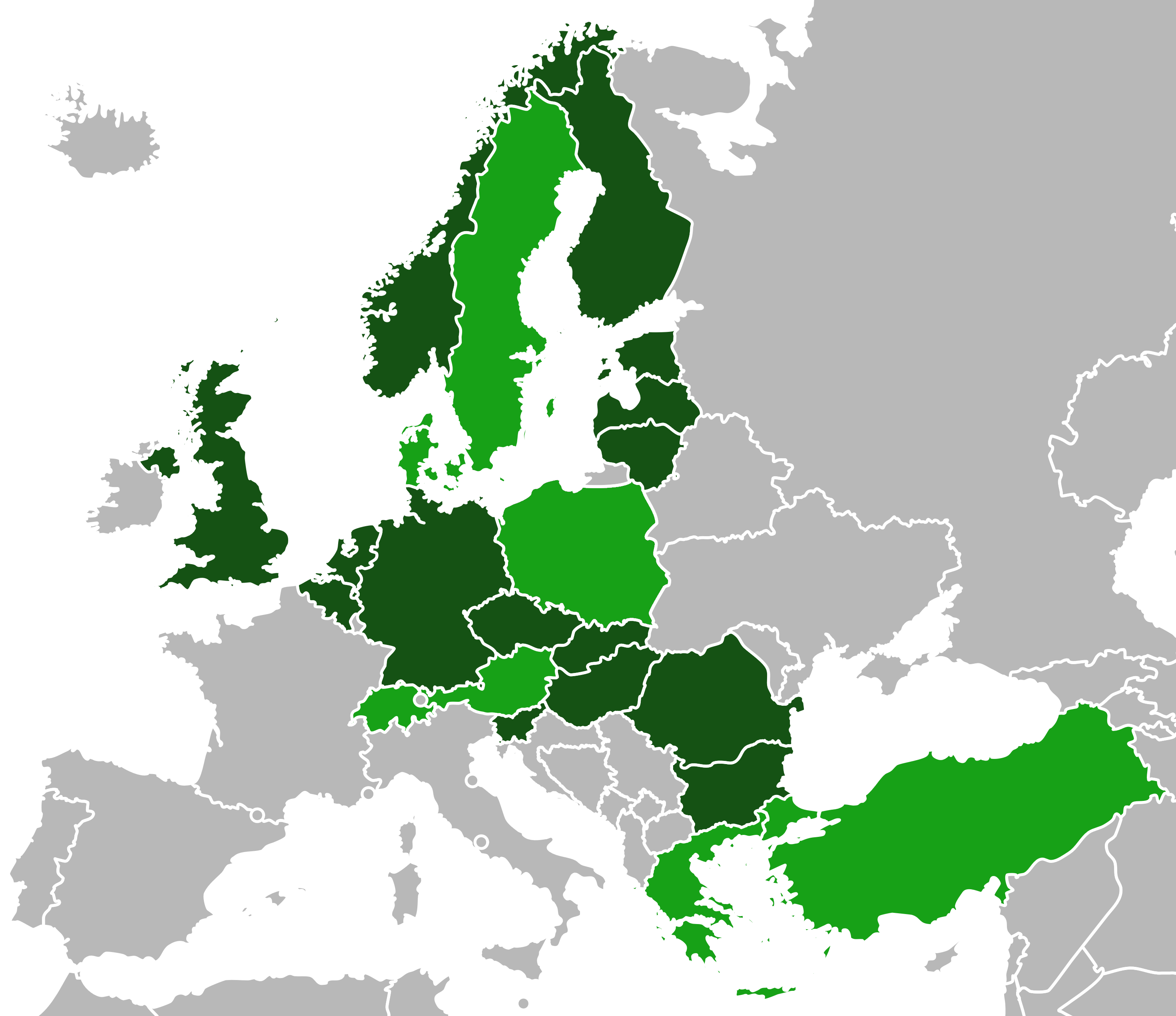
Deutsch: Karte der Teilnehmer der European Sky Shield Initiative, 2024. Dunkelgrün (Gründungsmitglieder 2022), hellgrün (Neumitglieder 2023 und 2024).
English: Map of European Sky Shield Initiative Members, 2023. Dark green (founding members in 2022), light green (joined members in 2023 and 2024.
Русский: Карта участников Небесного Щита Европы, 2024 г. Темно-зеленый (члены-учредители 2022 г.), светло-зеленый (новые члены 2023 и 2024 г.).
Română: Harta participanților la Inițiativa Scutul Cerului European, 2023. Verde închis (membri fondatori 2022), verde deschis (membri noi 2023 și 2024.
Tiếng Việt: Bản đồ những người tham gia Sáng kiến Lá chắn Bầu trời châu Âu, 2024. Xanh đậm (thành viên sáng lập 2022), xanh nhạt (thành viên mới 2023 và 2024.
Türkçe: Avrupa Gökyüzü Kalkanı Girişimi katılımcılarının haritası, 2024. Koyu yeşil (kurucu üyeler 2022), açık yeşil (yeni üyeler 2023 ve 2024.
中文:2023 年歐洲天空之盾倡議參與者地圖。深綠色(2022 年創始成員),淺綠色(2023, 2024)。 |
| Fecha | |
| Fuente | Trabajo propio de la persona que subió originalmente el archivo |
| Autor | Derkoenig |
| Otras versiones |
|


Licencia
[editar]
| This map was created for free at MapChart.net. All maps created there are licensed under the Creative Commons Attribution-ShareAlike 4.0 International License. See the "Licensing" link on the home page, or the MapChart.net feedback page for the image license info, and this MapChart.net Commons discussion. Use {{Mapchart.net}} to provide attribution for maps created with that service.
See also: Other maps on Commons created with Mapchart.net: Category:Mapchart.net and this search query; other map and chart resources. |
Yo, el titular de los derechos de autor de esta obra, la publico en los términos de la siguiente licencia:
Este archivo está disponible bajo la licencia Creative Commons Attribution-Share Alike 4.0 International.
- Eres libre:
- de compartir – de copiar, distribuir y transmitir el trabajo
- de remezclar – de adaptar el trabajo
- Bajo las siguientes condiciones:
- atribución – Debes otorgar el crédito correspondiente, proporcionar un enlace a la licencia e indicar si realizaste algún cambio. Puedes hacerlo de cualquier manera razonable pero no de manera que sugiera que el licenciante te respalda a ti o al uso que hagas del trabajo.
- compartir igual – En caso de mezclar, transformar o modificar este trabajo, deberás distribuir el trabajo resultante bajo la misma licencia o una compatible como el original.
Historial del archivo
Haz clic sobre una fecha y hora para ver el archivo tal como apareció en ese momento.
| Fecha y hora | Miniatura | Dimensiones | Usuario | Comentario | |
|---|---|---|---|---|---|
| actual | 09:57 6 may 2024 | | 2942 × 2541 (542 kB) | JB-Firefox (discusión | contribs.) | Uploaded own work with UploadWizard |
No puedes sobrescribir este archivo.
Usos del archivo
Las siguientes páginas usan este archivo:
Uso global del archivo
Las wikis siguientes utilizan este archivo:
- Uso en de.wikipedia.org
- Uso en en.wikipedia.org
- Uso en es.wikipedia.org
- Uso en pl.wikipedia.org
- Uso en ro.wikipedia.org
- Uso en ru.wikipedia.org
- Uso en uk.wikipedia.org
- Uso en vi.wikipedia.org
- Uso en www.wikidata.org
- Uso en zh.wikipedia.org