File:Temperatur i Karasjok og på Iškoras.png
Jump to navigation
Jump to search

Size of this preview: 800 × 276 pixels. Other resolutions: 320 × 110 pixels | 640 × 221 pixels | 1,024 × 353 pixels | 2,674 × 922 pixels.
Original file (2,674 × 922 pixels, file size: 162 KB, MIME type: image/png)
Captions
Captions
Add a one-line explanation of what this file represents
Summary
[edit]
| Description |
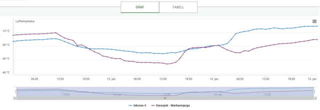
Norsk bokmål: Karasjok ligger 131 meter over havet og Iškoras 591 meter over havet. Det er 20 kilometer fra Karasjok til Iškoras, slik at været er noenlunde det samme. Temperaturforskjellen mellom de to skyldes i all hovedsak høydeforskjellen. Nå er Iškoras også en værstasjon som ligger på bakken, innenfor grenselaget, men temperaturen her er nesten konstant gjennom hele 13. januar, mens Karasjok har stor dag-natt-variasjon.
Diagrammet er hentet fra seklima.no, og målingene er fra 12.–14. januar 2021. |
| Date | |
| Source | Own work |
| Author | Isakslettebo |
Licensing
[edit]
I, the copyright holder of this work, hereby publish it under the following license:
This file is licensed under the Creative Commons Attribution-Share Alike 4.0 International license.
- You are free:
- to share – to copy, distribute and transmit the work
- to remix – to adapt the work
- Under the following conditions:
- attribution – You must give appropriate credit, provide a link to the license, and indicate if changes were made. You may do so in any reasonable manner, but not in any way that suggests the licensor endorses you or your use.
- share alike – If you remix, transform, or build upon the material, you must distribute your contributions under the same or compatible license as the original.
File history
Click on a date/time to view the file as it appeared at that time.
| Date/Time | Thumbnail | Dimensions | User | Comment | |
|---|---|---|---|---|---|
| current | 22:37, 5 November 2021 | 2,674 × 922 (162 KB) | Isakslettebo (talk | contribs) | Cross-wiki upload from no.wikipedia.org |
You cannot overwrite this file.
File usage on Commons
There are no pages that use this file.