File:Tennessee Amphitheater, World’s Fair Park, Knoxville, TN - 52473476511.jpg
Jump to navigation
Jump to search

Size of this preview: 800 × 600 pixels. Other resolutions: 320 × 240 pixels | 640 × 480 pixels | 1,024 × 768 pixels | 1,280 × 960 pixels | 2,560 × 1,920 pixels | 4,032 × 3,024 pixels.
Original file (4,032 × 3,024 pixels, file size: 5.31 MB, MIME type: image/jpeg)
Captions
Captions
Add a one-line explanation of what this file represents
Summary[edit]
| Description |
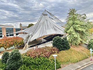
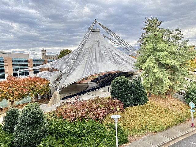
English: Built for the 1982 World’s Fair, this structure was designed by Horst Berger and McCarty Bullock and Holsaple Architects, and features seating for 1400 spectators, with the stage of the amphitheater backing up to the adjacent artificial pond on the fairgrounds. The design of the structure’s roof utilizes tensile fabric membranes, a type of structural system pioneered by Horst Berger, which was contemporaneously utilized on the Hubert H. Humphrey Metrodome in Minneapolis, Minnesota, gracefully floats above the seating area, with a separate shade structure covering the stage, supported by a more conventional steel structure. Despite its cultural significance as a performance venue that has hosted many notable bands, and architectural significance as a great example of a tensile fabric roof system, the structure was proposed for demolition in 2002, but thanks to public outcry, was instead renovated between 2005 and 2007, with the amphitheater continuing to host live performances. |
| Date | |
| Source | https://www.flickr.com/photos/59081381@N03/52473476511/ |
| Author | w_lemay |
| Camera location | | View this and other nearby images on: OpenStreetMap |
|---|
Licensing[edit]
This file is licensed under the Creative Commons Attribution-Share Alike 2.0 Generic license.
- You are free:
- to share – to copy, distribute and transmit the work
- to remix – to adapt the work
- Under the following conditions:
- attribution – You must give appropriate credit, provide a link to the license, and indicate if changes were made. You may do so in any reasonable manner, but not in any way that suggests the licensor endorses you or your use.
- share alike – If you remix, transform, or build upon the material, you must distribute your contributions under the same or compatible license as the original.
| This image was originally posted to Flickr by w_lemay at https://flickr.com/photos/59081381@N03/52473476511. It was reviewed on 8 March 2023 by FlickreviewR 2 and was confirmed to be licensed under the terms of the cc-by-sa-2.0. |
File history
Click on a date/time to view the file as it appeared at that time.
| Date/Time | Thumbnail | Dimensions | User | Comment | |
|---|---|---|---|---|---|
| current | 18:23, 8 March 2023 | | 4,032 × 3,024 (5.31 MB) | Ser Amantio di Nicolao (talk | contribs) | Uploaded a work by w_lemay from https://www.flickr.com/photos/59081381@N03/52473476511/ with UploadWizard |
You cannot overwrite this file.
File usage on Commons
There are no pages that use this file.
File usage on other wikis
The following other wikis use this file:
- Usage on en.wikipedia.org
- Usage on simple.wikipedia.org
- Usage on zh.wikipedia.org