File:Teriberka.jpg
跳转到导航
跳转到搜索

本预览的尺寸:800 × 533像素。 其他分辨率:320 × 213像素 | 640 × 427像素 | 1,024 × 683像素 | 1,280 × 853像素 | 2,560 × 1,707像素 | 5,472 × 3,648像素。
原始文件 (5,472 × 3,648像素,文件大小:4.16 MB,MIME类型:image/jpeg)
说明
说明
添加一行文字以描述该文件所表现的内容
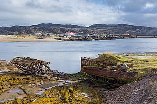
Teriberka village, Kola peninsula
摘要
[编辑]
| 描述 |
English: Teriberka village near Murmansk, Kola peninsula, Russia
Deutsch: Fischerdorf Teriberka nahe Murmansk, Kola-Halbinsel, Russland
Русский: Териберка, Кольский полуостров
Nederlands: Het dorp Teriberka op het Russische schiereiland Kola
Português: Restos de um barco na aldeia de Teriberka, península de Kola, Rússia
Sardu: Bidditzolu de Teriberka, in sa penìsula de Kola, in Rùssia |
| 日期 | 摄于2016年9月16日, 14:00:39 |
| 来源 | 自己的作品 |
| 作者 | Dmitry A. Mottl |
| Openstreetmap entry | Link to Openstreetmap |
| 物体位置 | | 在以下服务上查看本图像和附近其他图像: OpenStreetMap |
|---|
| 相机位置 | | 在以下服务上查看本图像和附近其他图像: OpenStreetMap |
|---|
评价
[编辑]
This image was selected as picture of the day on Wikimedia Commons for 30 June 2020. It was captioned as follows: Other languages:
Nederlands: Het dorp Teriberka op het Russische schiereiland Kola Português: Restos de um barco na aldeia de Teriberka, península de Kola, Rússia |
许可协议
[编辑]
我,本作品著作权人,特此采用以下许可协议发表本作品:
本文件采用知识共享署名-相同方式共享 4.0 国际许可协议授权。
- 您可以自由地:
- 共享 – 复制、发行并传播本作品
- 修改 – 改编作品
- 惟须遵守下列条件:
- 署名 – 您必须对作品进行署名,提供授权条款的链接,并说明是否对原始内容进行了更改。您可以用任何合理的方式来署名,但不得以任何方式表明许可人认可您或您的使用。
- 相同方式共享 – 如果您再混合、转换或者基于本作品进行创作,您必须以与原先许可协议相同或相兼容的许可协议分发您贡献的作品。
文件历史
点击某个日期/时间查看对应时刻的文件。
| 日期/时间 | 缩略图 | 大小 | 用户 | 备注 | |
|---|---|---|---|---|---|
| 当前 | 2016年9月25日 (日) 13:17 | | 5,472 × 3,648(4.16 MB) | Dmottl(留言 | 贡献) | User created page with UploadWizard |
您不可以覆盖此文件。
文件用途
以下32个页面使用本文件:
- User:Dmottl
- User:Eatcha/POTY-2018-Round-1-Results
- User talk:Dmottl
- Commons:Featured picture candidates/File:Teriberka.jpg
- Commons:Featured picture candidates/Log/December 2018
- Commons:Featured pictures/Places/Natural/Russia
- Commons:Featured pictures/chronological/2018-B
- Commons:Files used on OpenStreetMap/42
- Commons:Picture of the Year/2018/Candidates
- Commons:Picture of the Year/2018/R1/Gallery/2018-B
- Commons:Picture of the Year/2018/R1/Gallery/ALL
- Commons:Picture of the Year/2018/R1/Gallery/M12
- Commons:Picture of the Year/2018/R1/Gallery/Waters
- Commons:Picture of the Year/2018/R1/v/Teriberka.jpg
- Commons:Quality images/Subject/Architecture/Cityscapes/Archive 2018
- Commons:Quality images candidates/Archives January 13 2018
- Template:Potd/2020-06
- Template:Potd/2020-06-30
- Template:Potd/2020-06-30 (cs)
- Template:Potd/2020-06-30 (en)
- Template:Potd/2020-06-30 (es)
- Template:Potd/2020-06-30 (hu)
- Template:Potd/2020-06-30 (ko)
- Template:Potd/2020-06-30 (mk)
- Template:Potd/2020-06-30 (myv)
- Template:Potd/2020-06-30 (nl)
- Template:Potd/2020-06-30 (pl)
- Template:Potd/2020-06-30 (pt)
- Template:Potd/2020-06-30 (pt-br)
- Template:Potd/2020-06-30 (ru)
- Template:Potd/2020-06-30 (zh)
- Category:Ship graveyard of Teriberka
全域文件用途
以下其他wiki使用此文件:
- azb.wikipedia.org上的用途
- be-tarask.wikipedia.org上的用途
- crh.wikipedia.org上的用途
- cv.wikipedia.org上的用途
- fr.wikipedia.org上的用途
- hu.wikipedia.org上的用途
- hy.wikipedia.org上的用途
- incubator.wikimedia.org上的用途
- ka.wikipedia.org上的用途
- ko.wikipedia.org上的用途
- lbe.wikipedia.org上的用途
- lez.wikipedia.org上的用途
- mk.wikipedia.org上的用途
- os.wikipedia.org上的用途
- pt.wikipedia.org上的用途
- ru.wikipedia.org上的用途
- ru.wikinews.org上的用途
- sah.wikipedia.org上的用途
- sc.wikipedia.org上的用途
- sq.wikipedia.org上的用途
- sv.wikipedia.org上的用途
- tt.wikipedia.org上的用途
- vep.wikipedia.org上的用途
- www.wikidata.org上的用途
- zh.wikipedia.org上的用途