File:Terrified hill, osun state.jpg
Jump to navigation
Jump to search

Size of this preview: 800 × 273 pixels. Other resolutions: 320 × 109 pixels | 640 × 219 pixels | 1,024 × 350 pixels | 1,280 × 437 pixels | 2,560 × 874 pixels | 10,708 × 3,656 pixels.
Original file (10,708 × 3,656 pixels, file size: 7.23 MB, MIME type: image/jpeg)
Captions
Captions
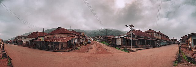
Road that leads to oke imesi hill, Esa-oke osun sate
Summary[edit]
| Description |
English: The three roads that leads to the hill that divide Oke-imesi and Esa-oke
|
||
| Date | |||
| Source | Own work | ||
| Author | Asokeretope | ||
| Other versions |
| Camera location | | View this and other nearby images on: OpenStreetMap |
|---|
Licensing[edit]
I, the copyright holder of this work, hereby publish it under the following license:
This file is licensed under the Creative Commons Attribution-Share Alike 4.0 International license.
- You are free:
- to share – to copy, distribute and transmit the work
- to remix – to adapt the work
- Under the following conditions:
- attribution – You must give appropriate credit, provide a link to the license, and indicate if changes were made. You may do so in any reasonable manner, but not in any way that suggests the licensor endorses you or your use.
- share alike – If you remix, transform, or build upon the material, you must distribute your contributions under the same or compatible license as the original.

|
This image was uploaded as part of Wiki Loves Africa 2020 photographic contest.
|

File history
Click on a date/time to view the file as it appeared at that time.
| Date/Time | Thumbnail | Dimensions | User | Comment | |
|---|---|---|---|---|---|
| current | 11:30, 27 February 2020 | 10,708 × 3,656 (7.23 MB) | Asokeretope (talk | contribs) | User created page with UploadWizard |
You cannot overwrite this file.
File usage on Commons
The following page uses this file: