File:Tharsis-PIA02049.jpg

原始檔案 (768 × 640 像素,檔案大小:59 KB,MIME 類型:image/jpeg)
說明
說明
摘要
[編輯]
| 描述 |
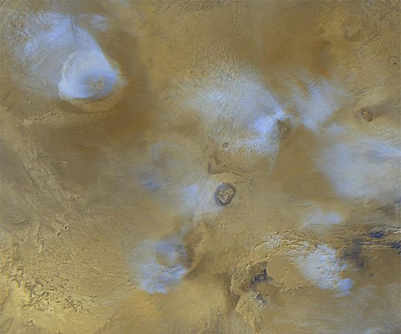
Uploaded from wikipedia. Original caption is/was here. Original Caption Released with Image: The volcanoes of the Tharsis region are highlighted by this color image mosaic obtained on a single martian afternoon by the Mars Orbiter Camera (MOC) onboard the Mars Global Surveyor (MGS) spacecraft. Olympus Mons dominates the upper left corner -- it is one of the largest known volcanoes and is nearly 550 km (340 miles) wide. The grayscale image on the right shows the name of each volcano in the scene. The white or bluish-white features are clouds. Clouds are common over the larger Tharsis volcanoes in mid-afternoon. The four largest volcanoes are more than 15 km (9 mi) high. Viewed from Earth by telescope before any spacecraft had visited the planet, astronomers often described a "W"-shaped white cloud over the Tharsis region. This "W" was actually the result of seeing the combined effects of bright clouds hanging over the Ascraeus, Pavonis, Arsia, and Olympus volcanoes. The clouds result when warm air containing water vapor rises up the slopes of each volcano, cools at the higher altitude, and causes the water vapor to freeze and form a cloud of ice crystals. Pavonis Mons lies on the martian equator, north is up, and sunlight is illuminating the scene from the left. The picture is a mosaic of red and blue filter images taken on three consecutive orbits. The slightly blurred appearance of the left side of Arsia Mons results from distortion toward the edges of the images used to make the mosaic. To remove the blur, an image obtained on another day would be added to the mosaic--however, this image would not match well because the cloud patterns will have changed by the next day. Mosaics such as the one shown here are used to monitor changes in martian weather and to plan future observations. Credit line: "Courtesy NASA/JPL-Caltech." |
| 來源 | Original source:http://photojournal.jpl.nasa.gov/catalog/PIA02049 |
| 作者 | NASA/JPL-Caltech |
| 此標籤不表示文件的著作權狀態。任何文件在附有此標籤的同時還需要一個有效的著作權標籤。請參閱許可協議說明頁面以了解更多資訊。 其他語言:
|
授權條款
[編輯]
| 本作品由NASA創作,屬於公有領域。根據NASA的版權政策:“NASA的創作除非另有聲明否則不受版權保護。”(參見:Template:PD-USGov/zh,NASA版權政策或JPL圖像使用政策) | ||
 |
警告:
|
原始上傳日誌
[編輯]
- 2004-05-06 18:38 Wwoods 768×640×8 (60174 bytes) Tharsis region on Mars; http://photojournal.jpl.nasa.gov/catalog/PIA02049 ;{{msg:PD}}
檔案歷史
點選日期/時間以檢視該時間的檔案版本。
| 日期/時間 | 縮圖 | 尺寸 | 用戶 | 備註 | |
|---|---|---|---|---|---|
| 目前 | 2008年4月29日 (二) 15:59 | | 768 × 640(59 KB) | Njardarlogar(對話 | 貢獻) | {{Information |Description= Uploaded from wikipedia. Original caption is/was [http://en.wikipedia.org/wiki/Image:Tharsis-PIA02049.jpg here]. '''Original Caption Released with Image''': The volcanoes of the Tharsis region are highlighted by this colo |
無法覆蓋此檔案。
檔案用途
沒有使用此檔案的頁面。
全域檔案使用狀況
以下其他 wiki 使用了這個檔案:
- ar.wikipedia.org 的使用狀況
- az.wikipedia.org 的使用狀況
- be.wikipedia.org 的使用狀況
- cy.wikipedia.org 的使用狀況
- el.wikipedia.org 的使用狀況
- en.wikipedia.org 的使用狀況
- fr.wikipedia.org 的使用狀況
- hi.wikipedia.org 的使用狀況
- hr.wikipedia.org 的使用狀況
- hy.wikipedia.org 的使用狀況
- id.wikipedia.org 的使用狀況
- it.wikipedia.org 的使用狀況
- ja.wikipedia.org 的使用狀況
- ko.wikipedia.org 的使用狀況
- lt.wikipedia.org 的使用狀況
- mk.wikipedia.org 的使用狀況
- ml.wikipedia.org 的使用狀況
- nl.wikipedia.org 的使用狀況
- nn.wikipedia.org 的使用狀況
- no.wikipedia.org 的使用狀況
- pl.wikipedia.org 的使用狀況
- pt.wikipedia.org 的使用狀況
- ru.wikipedia.org 的使用狀況
- zh.wikipedia.org 的使用狀況