File:The spatial distribution of Plasmodium vivax malaria endemicity map in 2010 globally.png
Jump to navigation
Jump to search

Size of this preview: 800 × 566 pixels. Other resolutions: 320 × 226 pixels | 640 × 453 pixels | 1,024 × 724 pixels | 1,280 × 906 pixels | 1,880 × 1,330 pixels.
Original file (1,880 × 1,330 pixels, file size: 815 KB, MIME type: image/png)
Captions
Captions
Add a one-line explanation of what this file represents
| Description |
English: This image was obtained from www.map.ox.ac.uk
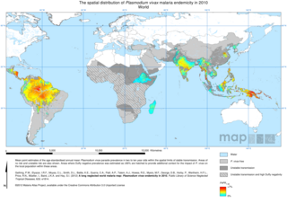
This map shows estimated levels of Plasmodium vivax malaria endemicity within the limits of stable transmission. The mapped variable is the age-standardised P. vivax Parasite Rate (PvPR0-99) which describes the estimated proportion of the general population that are infected with P. vivax at any one time, averaged over the 12 months of 2010. Estimates are made based on data from parasite rate surveys which feed into a geostatistical model that produces a a range of predicted endemicities for each location (a probability distribution). The model also uses data from environmental covariates which help predict more accurately, especially in areas far from any actual survey data. The environmental covariates include rainfall, temperature, land cover and urban/ rural status. The model incorporated data on Duffy negativity in human populations, particularly in Africa, and we also provide a separate map of the predicted frequency of Duffy negativity. The endemicity map displayed shows the mean value for the probability distribution at each location (approx. 5km2). |
| Date | |
| Source | http://www.plosntds.org/article/info:doi/10.1371/journal.pntd.0001814 |
| Author | Gething, P.W., et al. |
| Permission (Reusing this file) |
http://www.plosntds.org/article/info:doi/10.1371/journal.pntd.0001814 |
| This work has been released into the public domain by its author, Gething, P.W., et al.. This applies worldwide. In some countries this may not be legally possible; if so: Gething, P.W., et al. grants anyone the right to use this work for any purpose, without any conditions, unless such conditions are required by law.
|
File history
Click on a date/time to view the file as it appeared at that time.
| Date/Time | Thumbnail | Dimensions | User | Comment | |
|---|---|---|---|---|---|
| current | 16:17, 9 May 2013 | | 1,880 × 1,330 (815 KB) | PHPox (talk | contribs) | {{subst:Upload marker added by en.wp UW}} {{Information |Description = {{en|This image was obtained from www.map.ox.ac.uk This map shows estimated levels of Plasmodium vivax malaria endemicity within the limits of stable transmission. The mapped vari... |
You cannot overwrite this file.
File usage on Commons
There are no pages that use this file.
File usage on other wikis
The following other wikis use this file:
- Usage on en.wikipedia.org
- Usage on eu.wikipedia.org
- Usage on zh.wikipedia.org