File:The topography of Moreux crater ESA21868053.jpeg
Jump to navigation
Jump to search

Size of this preview: 800 × 297 pixels. Other resolutions: 320 × 119 pixels | 640 × 237 pixels | 1,024 × 380 pixels | 1,280 × 475 pixels | 2,560 × 949 pixels | 9,711 × 3,600 pixels.
Original file (9,711 × 3,600 pixels, file size: 7.79 MB, MIME type: image/jpeg)
Captions
Captions
Add a one-line explanation of what this file represents
Summary
[edit]| Description |
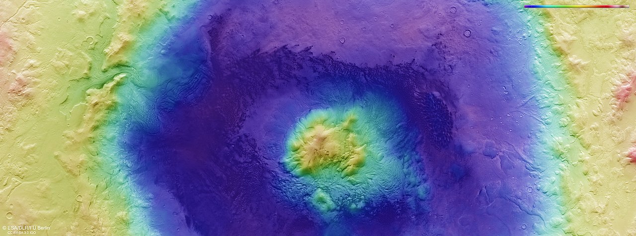
English: This colour-coded topographic image shows a feature on Mars’ surface named Moreux crater, based on data gathered by the Mars Express High Resolution Stereo Camera on 30 October 2019 during orbit 20014. This view is based on a digital terrain model (DTM) of the region, from which the topography of the landscape can be derived; lower parts of the surface are shown in blues and purples, while higher altitude regions show up in whites, yellows and reds, as indicated on the scale to the bottom left. North is to the right. |
| Date | 5 March 2020 (upload date) |
| Source | The topography of Moreux crater |
| Author | ESA/DLR/FU Berlin |
| Other versions |
|
| Activity | Space Science |
| Mission | Mars Express |


Licensing
[edit]
This media was created by the European Space Agency (ESA).
Where expressly so stated, images or videos are covered by the Creative Commons Attribution-ShareAlike 3.0 IGO (CC BY-SA 3.0 IGO) licence, ESA being an Intergovernmental Organisation (IGO), as defined by the CC BY-SA 3.0 IGO licence. The user is allowed under the terms and conditions of the CC BY-SA 3.0 IGO license to Reproduce, Distribute and Publicly Perform the ESA images and videos released under CC BY-SA 3.0 IGO licence and the Adaptations thereof, without further explicit permission being necessary, for as long as the user complies with the conditions and restrictions set forth in the CC BY-SA 3.0 IGO licence, these including that:
See the ESA Creative Commons copyright notice for complete information, and this article for additional details.
|
 | |
This file is licensed under the Creative Commons Attribution-ShareAlike 3.0 IGO license. Attribution: ESA/DLR/FU Berlin, CC BY-SA IGO 3.0
| ||
File history
Click on a date/time to view the file as it appeared at that time.
| Date/Time | Thumbnail | Dimensions | User | Comment | |
|---|---|---|---|---|---|
| current | 11:31, 7 June 2020 | 9,711 × 3,600 (7.79 MB) | OptimusPrimeBot (talk | contribs) | #Spacemedia - Upload of https://www.esa.int/var/esa/storage/images/esa_multimedia/images/2020/03/the_topography_of_moreux_crater/21868042-1-eng-GB/The_topography_of_Moreux_crater.jpg via Commons:Spacemedia |
You cannot overwrite this file.
File usage on Commons
The following 6 pages use this file: