File:The wildfire emergency continues in Greece.jpeg

Original file (4,410 × 2,540 pixels, file size: 4.88 MB, MIME type: image/jpeg)
Captions
Captions
Summary[edit]
| Description |
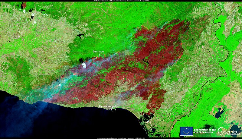
English: Multiple fires continue to ravage Greece. Among the most significant are those currently raging in the Sterea Ellada region, the East Macedonia and Thrace regions, and on the islands of Euboea and Rhodope. One of the fires that is causing the worst destruction is the one ongoing in the East Macedonia and Thrace region. Firefighters are actively working to prevent the fire from progressing toward Dadia National Park, where the charred remains of 18 people were found. The burn scar of this fire is visible in this image acquired by one of the Copernicus Sentinel-2 satellites on 23 August. The Rapid Mapping module of the Copernicus Emergency Management Service (CEMS) has been activated (EMSR686) to provide detailed burn scar delineation and damage grading maps of the affected areas. According to CEMS, the affected area as of 23 August 2023 stands at 72,344.5 ha. |
| Date | Taken on 23 August 2023 |
| Source | The wildfire emergency continues in Greece |
| Author | European Union, Copernicus Sentinel-2 imagery |
Licensing[edit]

|
This image contains data from a satellite in the Copernicus Programme, such as Sentinel-1, Sentinel-2 or Sentinel-3. Attribution is required when using this image.
Attribution: Contains modified Copernicus Sentinel data 2023
The use of Copernicus Sentinel Data is regulated under EU law (Commission Delegated Regulation (EU) No 1159/2013 and Regulation (EU) No 377/2014). Relevant excerpts:
Free access shall be given to GMES dedicated data [...] made available through GMES dissemination platforms [...].
Access to GMES dedicated data [...] shall be given for the purpose of the following use in so far as it is lawful:
GMES dedicated data [...] may be used worldwide without limitations in time.
GMES dedicated data and GMES service information are provided to users without any express or implied warranty, including as regards quality and suitability for any purpose. |
File history
Click on a date/time to view the file as it appeared at that time.
| Date/Time | Thumbnail | Dimensions | User | Comment | |
|---|---|---|---|---|---|
| current | 12:05, 25 August 2023 | | 4,410 × 2,540 (4.88 MB) | OptimusPrimeBot (talk | contribs) | #Spacemedia - Upload of https://www.copernicus.eu/system/files/2023-08/image_day/20230824_FiresGreece.png via Commons:Spacemedia |
You cannot overwrite this file.
File usage on Commons
There are no pages that use this file.
File usage on other wikis
The following other wikis use this file:
- Usage on el.wikipedia.org