File:Thomas Kitchin, A new improved map of Cornwall from the best surveys & intelligences divided into its hundreds (FL37660883 2582561).jpg
Jump to navigation
Jump to search

Size of this preview: 766 × 599 pixels. Other resolutions: 307 × 240 pixels | 613 × 480 pixels | 981 × 768 pixels | 1,280 × 1,002 pixels | 2,560 × 2,004 pixels | 17,532 × 13,721 pixels.
Original file (17,532 × 13,721 pixels, file size: 328.18 MB, MIME type: image/jpeg)
Captions
Captions
Add a one-line explanation of what this file represents
Summary
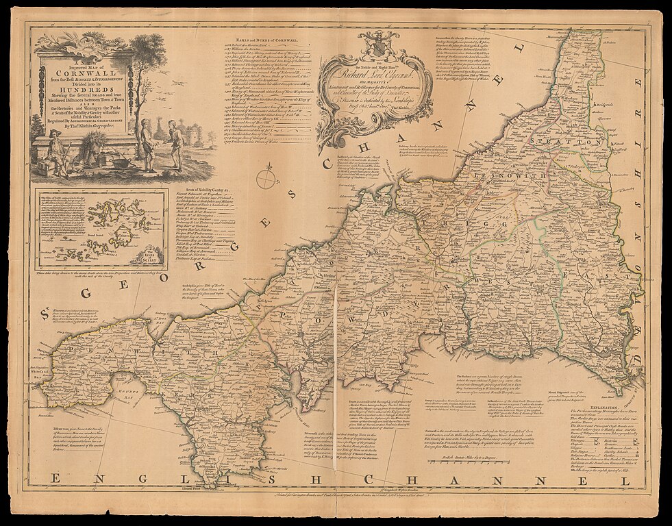
[edit]| Thomas Kitchin: A new improved map of Cornwall from the best surveys & intelligences divided into its hundreds
( |
||||||||||||||||||||||||
|---|---|---|---|---|---|---|---|---|---|---|---|---|---|---|---|---|---|---|---|---|---|---|---|---|
| Artist |
|
|||||||||||||||||||||||
| Title |
A new improved map of Cornwall from the best surveys & intelligences divided into its hundreds |
|||||||||||||||||||||||
| Publisher |
Printed for Carington Bowles ...& Rob Sayer ... |
|||||||||||||||||||||||
| Description |
A new improved map of Cornwall from the best surveys & intelligences divided into its hundreds. shewing the several roads and true measured distances between town & town also the rectories and vicarages the parks & seats of the nobility & gentry with other useful particulars regulated by astronomical observations . By Thos. Kitchin. |
|||||||||||||||||||||||
| Language | English | |||||||||||||||||||||||
| Publication date | circa 1764 | |||||||||||||||||||||||
| Medium | 1 map ; | |||||||||||||||||||||||
| Dimensions | height: 51 cm (20 in); width: 69 cm (27.1 in) | |||||||||||||||||||||||
| Collection |
|
|||||||||||||||||||||||
| Current location |
|
|||||||||||||||||||||||
| Place of publication | London | |||||||||||||||||||||||
| search Merhav catalog | London | |||||||||||||||||||||||
| Notes | Inset map: The isles of Scilly; From: Bowen, Emanuel Large English atlas c.1764. Numbered 7. | |||||||||||||||||||||||
| IE PID | IE37660877 | |||||||||||||||||||||||
| Rosetta filename | FL37660883 | |||||||||||||||||||||||
| NNL item ID (P3959) | 990025825610205171 | |||||||||||||||||||||||
| search Merhav catalog | English, Thomas Kitchin | |||||||||||||||||||||||
| search Merhav catalog | Printed for Carington Bowles ...& Rob Sayer ... | |||||||||||||||||||||||
| Source/Photographer |
|
|||||||||||||||||||||||
| Other versions | ||||||||||||||||||||||||
| Jpg / Tif version |
|
|||||||||||||||||||||||

.jpg)

.jpg&action=edit§ion=1)
Licensing
[edit].jpg&action=edit§ion=2)
The copyright situation of this work is theoretically uncertain, because in the country of origin copyright lasts 70 years after the death of the author, and the date of the author's death is unknown. However, the date of creation of the work was over 120 years ago, and it is thus a reasonable assumption that the copyright has expired (see here for the community discussion). Do not use this template if the date of death of the author is known.
| |
| This file has been identified as being free of known restrictions under copyright law, including all related and neighboring rights. | |
File history
Click on a date/time to view the file as it appeared at that time.
| Date/Time | Thumbnail | Dimensions | User | Comment | |
|---|---|---|---|---|---|
| current | 04:18, 2 September 2023 | | 17,532 × 13,721 (328.18 MB) | Geagea (talk | contribs) | pattypan 22.03 |
You cannot overwrite this file.
File usage on Commons
The following page uses this file:
.jpg&oldid=797721948)