File:Thomery-Port d'Effondré-2018 0421.jpg
Jump to navigation
Jump to search
Size of this preview: 800 × 533 pixels. Other resolutions: 320 × 213 pixels | 640 × 427 pixels | 1,024 × 683 pixels | 1,280 × 853 pixels | 2,560 × 1,707 pixels | 5,408 × 3,605 pixels.
Original file (5,408 × 3,605 pixels, file size: 3.7 MB, MIME type: image/jpeg)
Captions
Captions
Add a one-line explanation of what this file represents
Summary
[edit]
| Description |
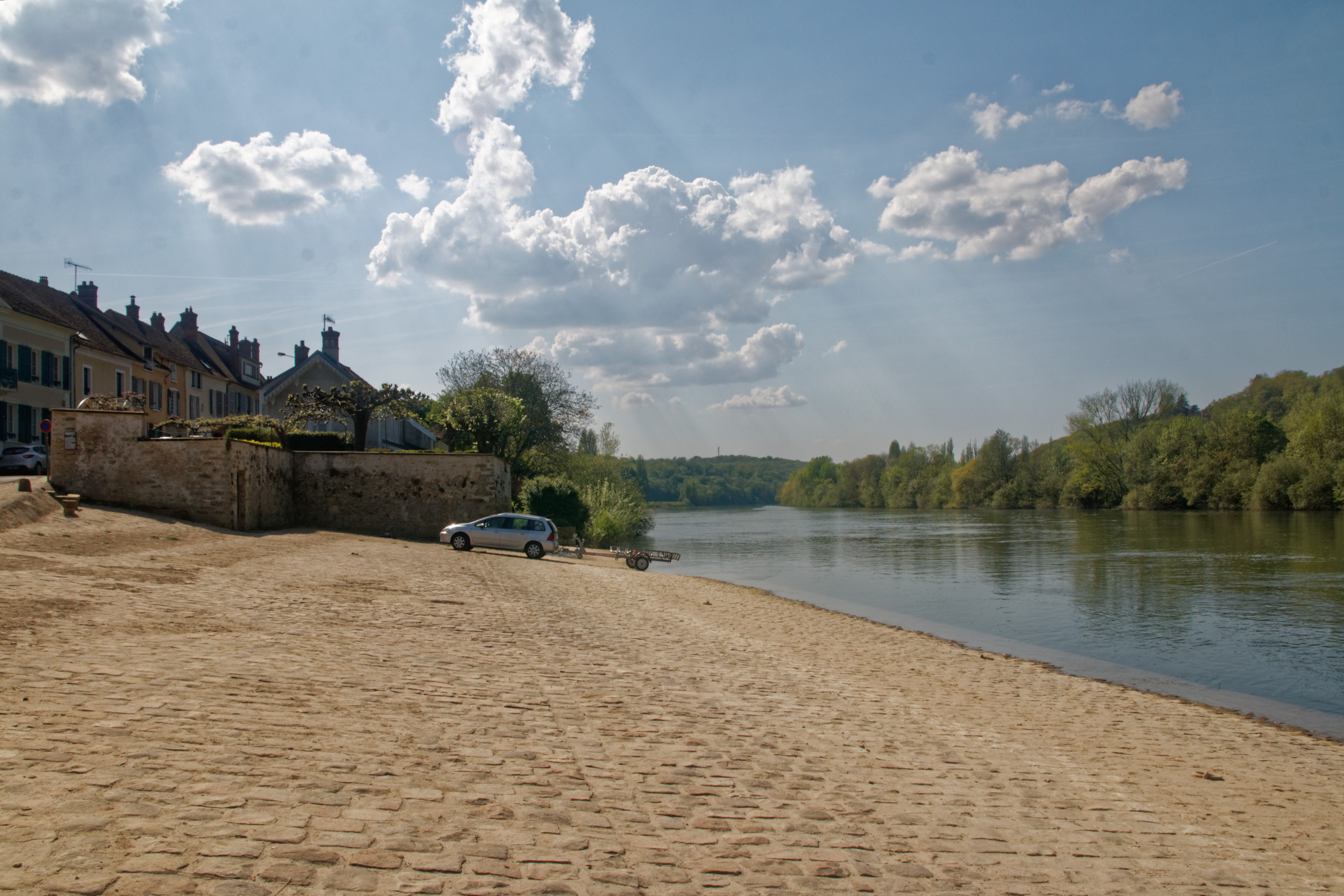
English: From 1380, there is a port at the flow of the water which develops in the 16th century with the exportation, to Paris, of the production of the brickyard of “ Effondré ”. In the 18th century the margotats[1] loaded with apples supplied the fruit market of Paris in the morning. From 19th century the apples are replaced by baskets of Chasselas grown in espaliers against many walls for chasselas in the neighbour city, By. It is at this time that is built the dock at the edge of the water. A paved line separates it from the upper part paid by the winemakers. From 1860, the activity of the port declines, the river transport being replaced progressively by the rail transport. Español: Desde 1380, hay un puerto al curso del agua que se amplia en el siglo XVI con la exportación, hacia Paris, de la producción de la adobería de „Éffondré“. En el siglo 18, los „margotats“[2] cargados de manzanas abastecen, por la mañana, el mercado de frutas de París. Despues el siglo 19 las manzanas estan reemplazadas por sartenes de uva albilla cultivadas en espalderas contra muchas paredes a uvas del municipio vecino, By. Es en este momento que se construyo el muelle a filo del agua. Una línea pavimentada separa de la parte superior pagada por los viticultores. Desde 1860, la actividad del puerto disminuye, el transporte fluvial estan reemplazado progresivamente por el transporte ferroviario. Français : Dès 1380, il existe un port au fil de l'eau qui se développe au 16° siècle avec l'exportion, à destination de Paris, de la production de la briquetterie d'Effondré. Au 18e siècle les margotats[3] chargés de pommes ravitaillent, dès le matin, le marché au fruits de Paris. A partir du 19e les pommes sont remplacées par les paniers de chasselas cultivés en espaliers contre nombreux murs à chasselas érigés dans la commune voisine, By. C'est à cette époque qu'est construit le quai au bord de l'eau. Un ligne pavée le sépare de la partie haute payée par les viticulteurs. À partir de 1860, l'activité du port décline, le transport fluvial étant remplacée progressivement par le transport ferroviaire.
|
| Date | Taken on 21 April 2018 |
| Source | Own work |
| Author | Daniel VILLAFRUELA. |
| Permission (Reusing this file) |
This file is licensed under the Creative Commons Attribution-Share Alike 4.0 International license.
|
| Object location | | View this and other nearby images on: OpenStreetMap |
|---|
File history
Click on a date/time to view the file as it appeared at that time.
| Date/Time | Thumbnail | Dimensions | User | Comment | |
|---|---|---|---|---|---|
| current | 09:22, 23 April 2018 | | 5,408 × 3,605 (3.7 MB) | Daniel VILLAFRUELA (talk | contribs) | == {{int:filedesc}} == <!-- Add your traduction at the multilingual descriptor {{mld}} or {{LangSwitch}}used in this page--> {{Information |Description= {{Mld |en= From 1380, there is a port at the flow of the water which develops in the 16th century with the exportation, to {{w|Paris||en}}, of the production of the brickyard of “ Effondré ”. In the 18th century the margotats<ref>'''Margotat''' : Margotats are sort of {{w|Scow|skows|en}} going down the river Seine over the water, some... |
You cannot overwrite this file.
File usage on Commons
The following page uses this file: