File:Thomsen River Estuary, Banks Island.jpeg
Original file (4,156 × 3,582 pixels, file size: 3.98 MB, MIME type: image/jpeg)
Captions
Captions
Summary
[edit]
| Description |
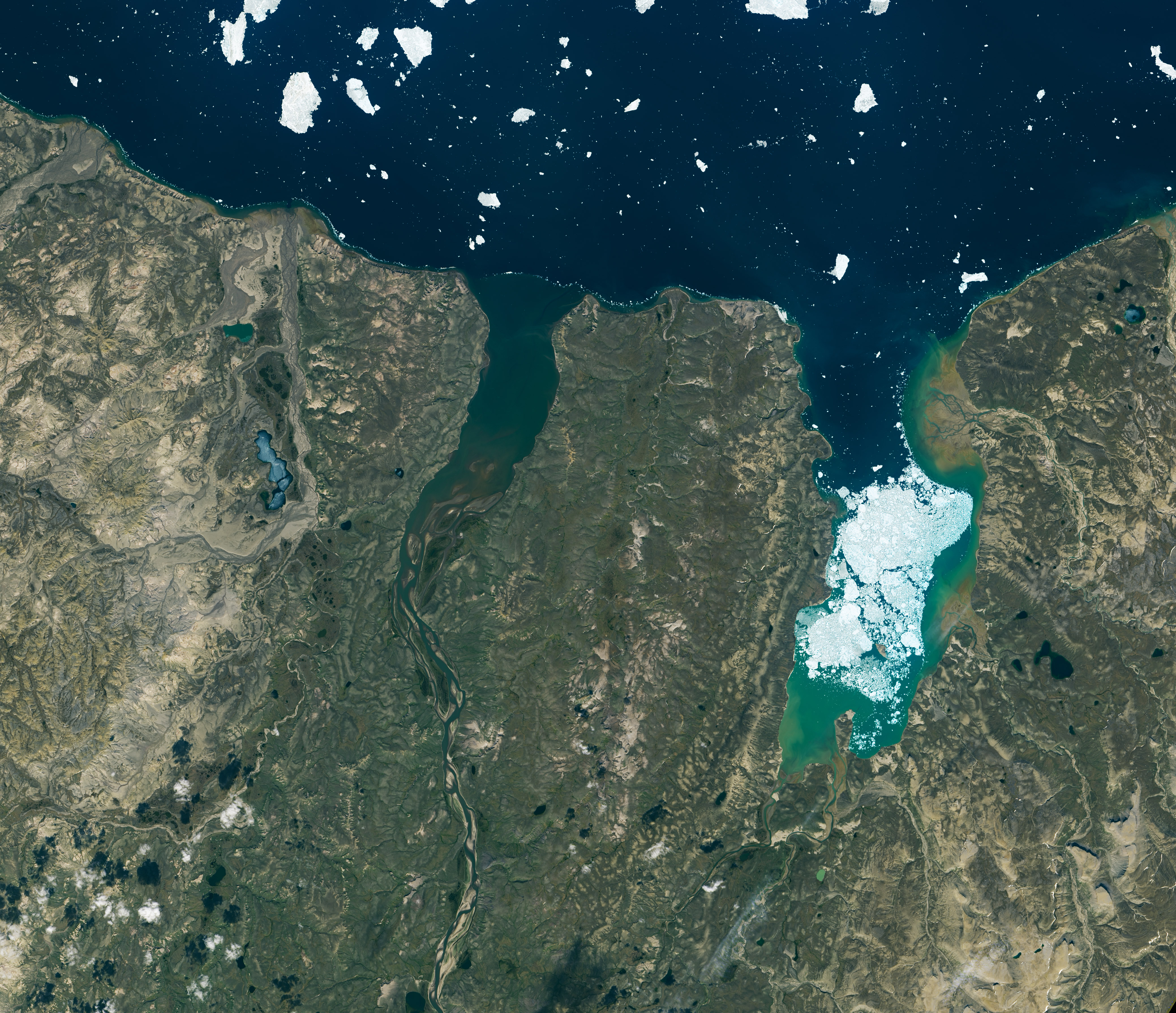
At the very top of North America, more than 36,000 islands large and small mingle with the icy waters of the Arctic Ocean. Collectively they comprise the Canadian Arctic Archipelago, and the region’s landscapes and waterscapes are stunningly beautiful. They are also quite remote, making satellite images a good way to explore the region. The northern side of Banks Island—the archipelago’s westernmost island—is visible in this image acquired on a rare cloud-free day in July 2015. Centered in the lower half of the image is Thomsen River, a remote destination within the Aulavik National Park that is well-known among canoeing enthusiasts. Visitors to the park—about a dozen in a typical year—are surrounded by Arctic tundra inhabited by muskox, snowy owls, and snow geese. Although summer was in full swing when the Operational Land Imager (OLI) on Landsat 8 acquired this image, bits of seasonal sea ice persisted offshore and within Mercy Bay. “Particularly obvious is the ‘pearl necklace’ of small ice floes worn by the coast,” said Robie Macdonald, a scientist at the University of Manitoba and the Canadian Department of Fisheries and Oceans. “These lines of bergy bits indicate grounded ice that has collected at delta fronts, or along a thin shore margin at the point where the sea bottom rapidly deepens below ice keel depths.” |
| Date | |
| Source | https://earthobservatory.nasa.gov/images/147560/thomsen-river-estuary-banks-island |
| Author | NASA Earth Observatory images by Lauren Dauphin, using Landsat data from the U.S. Geological Survey. Story by Kathryn Hansen. |
Licensing
[edit]
| This file is in the public domain in the United States because it was solely created by NASA. NASA copyright policy states that "NASA material is not protected by copyright unless noted". (See Template:PD-USGov, NASA copyright policy page or JPL Image Use Policy.) | ||
 |
Warnings:
|
File history
Click on a date/time to view the file as it appeared at that time.
| Date/Time | Thumbnail | Dimensions | User | Comment | |
|---|---|---|---|---|---|
| current | 02:19, 10 March 2021 | | 4,156 × 3,582 (3.98 MB) | StellarHalo (talk | contribs) | {{Information |Description=At the very top of North America, more than 36,000 islands large and small mingle with the icy waters of the Arctic Ocean. Collectively they comprise the Canadian Arctic Archipelago, and the region’s landscapes and waterscapes are stunningly beautiful. They are also quite remote, making satellite images a good way to explore the region. The northern side of Banks Island—the archipelago’s westernmost island—is visible in this image acquired on a rare cloud-free day... |
You cannot overwrite this file.
File usage on Commons
The following page uses this file: