File:Tianjin Metro System Map zh.png
Jump to navigation
Jump to search
Size of this preview: 800 × 496 pixels. Other resolutions: 320 × 198 pixels | 640 × 397 pixels | 1,024 × 635 pixels | 1,280 × 794 pixels | 2,256 × 1,399 pixels.
Original file (2,256 × 1,399 pixels, file size: 263 KB, MIME type: image/png)
Captions
Captions
Add a one-line explanation of what this file represents
Summary
[edit]
| Description |
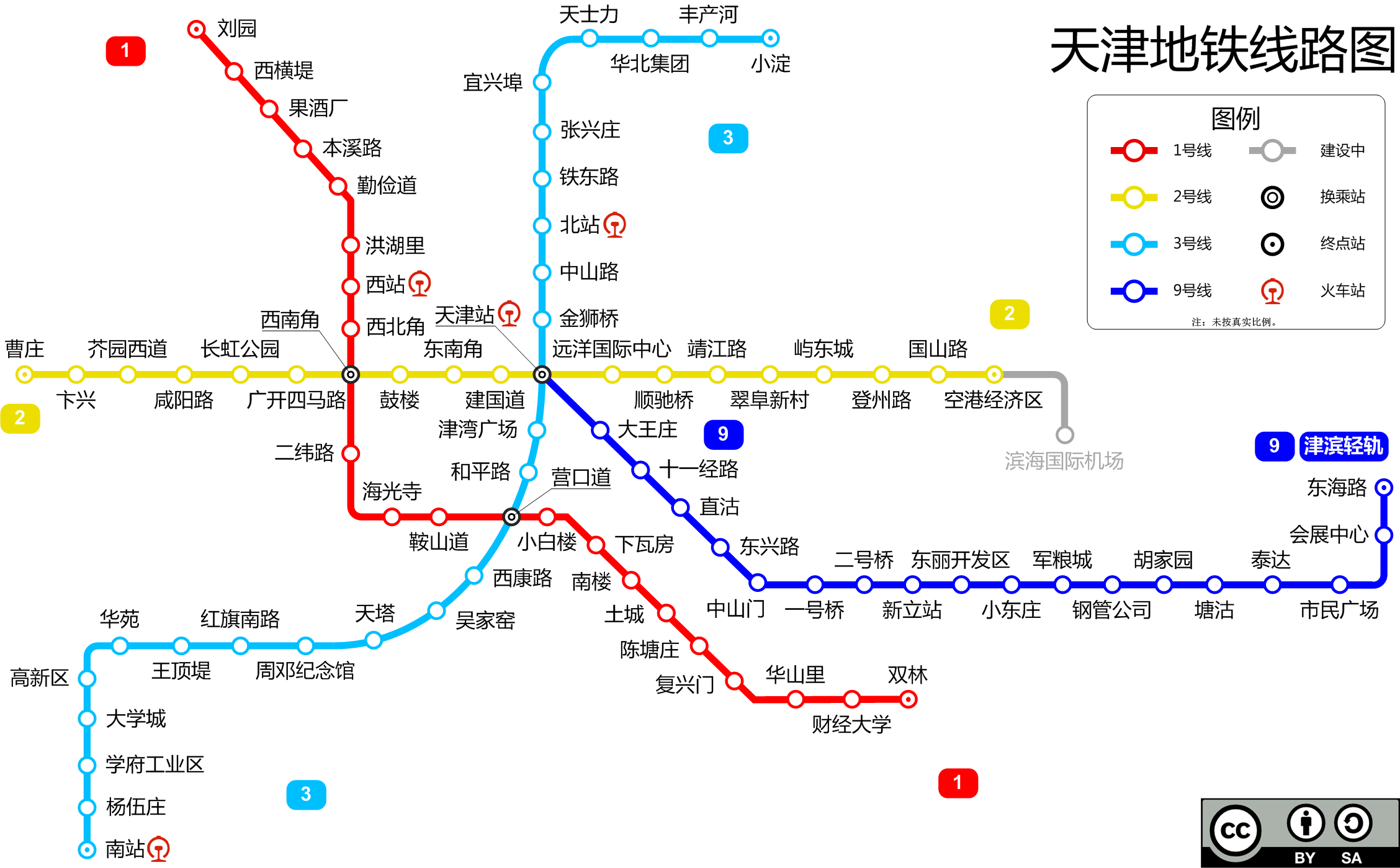
English: This is a map of the Tianjin Metro system (as of Oct, 2012).
中文(简体):这是天津轨道交通图(截至2012年10月)。 |
| Date | |
| Source | Own work |
| Author | User:Kuailong |
| Other versions |
 |

|
File:Tianjin Metro System Map Simplified Chinese.svg is a vector version of this file. It should be used in place of this PNG file when not inferior.
File:Tianjin Metro System Map zh.png → File:Tianjin Metro System Map Simplified Chinese.svg
For more information, see Help:SVG. |
 |
Licensing
[edit]
I, the copyright holder of this work, hereby publish it under the following license:
This file is licensed under the Creative Commons Attribution-Share Alike 3.0 Unported license.
- You are free:
- to share – to copy, distribute and transmit the work
- to remix – to adapt the work
- Under the following conditions:
- attribution – You must give appropriate credit, provide a link to the license, and indicate if changes were made. You may do so in any reasonable manner, but not in any way that suggests the licensor endorses you or your use.
- share alike – If you remix, transform, or build upon the material, you must distribute your contributions under the same or compatible license as the original.
File history
Click on a date/time to view the file as it appeared at that time.
| Date/Time | Thumbnail | Dimensions | User | Comment | |
|---|---|---|---|---|---|
| current | 23:45, 2 February 2014 | | 2,256 × 1,399 (263 KB) | Kuailong (talk | contribs) | 细部修正 |
| 02:23, 11 January 2014 |  | 2,256 × 1,399 (264 KB) | Kuailong (talk | contribs) | 三号线南延段开通 | |
| 20:19, 6 October 2013 |  | 2,256 × 1,399 (264 KB) | Kuailong (talk | contribs) | 走向调整以更接近现实 | |
| 21:55, 30 August 2013 |  | 2,256 × 1,399 (263 KB) | Kuailong (talk | contribs) | 修补瑕疵 | |
| 21:54, 30 August 2013 |  | 2,256 × 1,399 (263 KB) | Kuailong (talk | contribs) | 建国道站开通 | |
| 14:59, 30 July 2013 |  | 2,256 × 1,399 (264 KB) | Kuailong (talk | contribs) | 瑕疵修正 | |
| 14:44, 30 July 2013 |  | 2,256 × 1,399 (264 KB) | Kuailong (talk | contribs) | 移除导轨线路,调小站点标志圆大小,其他细部调整。 | |
| 02:28, 30 December 2012 |  | 2,261 × 1,412 (297 KB) | Kuailong (talk | contribs) | 修正瑕疵 | |
| 02:17, 30 December 2012 |  | 2,261 × 1,412 (299 KB) | Kuailong (talk | contribs) | 为绘制5、6号线做站位调整 | |
| 13:41, 9 December 2012 |  | 2,334 × 1,412 (299 KB) | Kuailong (talk | contribs) | 纠错 |
You cannot overwrite this file.
File usage on Commons
The following page uses this file: