File:Tilisunahütte Panorama.jpg
跳至導覽
跳至搜尋
預覽大小:800 × 211 像素。 其他解析度:320 × 84 像素 | 640 × 169 像素 | 1,024 × 270 像素 | 1,280 × 337 像素 | 6,711 × 1,768 像素。
原始檔案 (6,711 × 1,768 像素,檔案大小:8.68 MB,MIME 類型:image/jpeg)
說明
說明
添加單行說明來描述出檔案所代表的內容
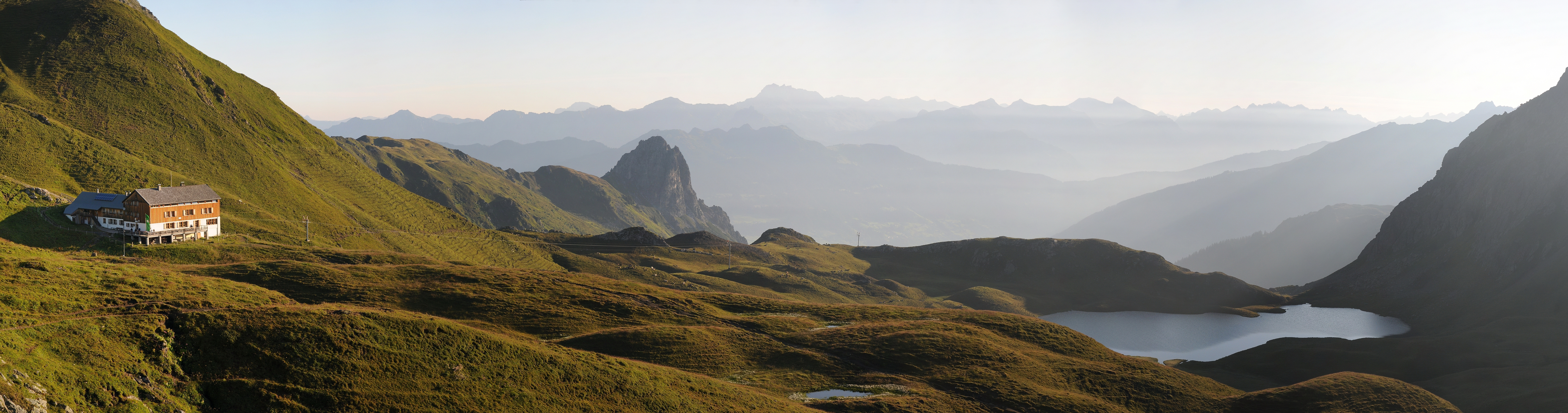
Panoramic picture of Rätikon mountain range in Austria, with Austrian Alpine Club hut Tilisunahütte on the left and Tilisunasee lake on the right.
| 描述 |
Čeština: Panorama z pohoří Rätikon v Rakousko, nedaleko hranic se Švýcarskem. Vlevo chata Tilisunahütte Rakouského alpského spolku ležící ve výšce 2211 m n. m.
Deutsch: Panorama um 07:10 Uhr nach dem Sonnenaufgang über dem Tilisunasee. Links die Tilisunahütte. Sie ist eine Berghütte des Österreichischen Alpenvereins (OeAV), Sektion Vorarlberg, in der Region Montafon, Bundesland Vorarlberg / Österreich. Sie liegt südlich von Tschagguns auf einer Höhe von 2'211 m ü. M. nördlich der Sulzfluh, in aussichtsreicher Lage mit Blick ins Montafon. Der Berganstieg links führt auf das Tilisuna-Schwarzhorn 2.460m und in der Bildmitte die Tschaggunser Mittagsspitze.
English: Panoramic picture of Rätikon mountain range in Austria, near the border of Switzerland, with Austrian Alpine Club hut Tilisunahütte on the left. Hut is located south of village Tschagguns in elevation of 2,211 m.
Русский: Окрестности Чаггунс, Форарльберг, Австрия.
Italiano: Foto panoramica della catena del Rätikon in Austria vicino al confine svizzero. Sulla sinistra il rifugio Tilisunahütte dell'Österreichischer Alpenverein.
|
||
| 日期 | |||
| 來源 | 自己的作品 | ||
| 作者 | böhringer friedrich | ||
| 授權許可 (重用此檔案) |
我,本作品的著作權持有者,決定用以下授權條款發佈本作品: 此檔案採用創用CC 姓名標示-相同方式分享 2.5 通用版授權條款。
|

| 拍攝地點 | | 位於此地的本圖片與其他圖片: OpenStreetMap |
|---|
This Photo was taken by Böhringer Friedrich.
|
Feel free to use my photos, but please mention me as the author and if you want send me a message. or (rufre@lenz-nenning.at) |
| 註解 | 該圖片含有註解:在維基媒體共享資源上查看註解 |
評價
[編輯]
|

This image was selected as picture of the day on Wikimedia Commons for 1 August 2012. It was captioned as follows: English: Panoramic picture of Rätikon mountain range in Austria, near the border of Switzerland, with Austrian Alpine Club hut Tilisunahütte on the left. Other languages:
English: Panoramic picture of Rätikon mountain range in Austria, near the border of Switzerland, with Austrian Alpine Club hut Tilisunahütte on the left. Italiano: Foto panoramica della catena del Rätikon in Austria vicino al confine svizzero. Sulla sinistra il rifugio Tilisunahütte dell'Österreichischer Alpenverein. Magyar: A Rätikon-hegység panorámaképe Ausztriában, közel a svájci határhoz. Bal oldalon a Tilisunahütte alpesi menedékház. Nederlands: Panoramische foto van het bergmassief Rätikon in Oostenrijk nabij de grens met Zwitserland met links de Tilisunahütte van de Österreichischer Alpenverein. Português: Imagem panorâmica da cordilheira Rätikon, na Áustria, próximo à fronteira com a Suíça. Русский: Панорама хребта Ретикон в Австрии. Слева горная хижина Тилисуна, принадлежащая Австрийскому Горному Клубу ქართული: რეტიკონის ქედის პანორამა ავსტრიაში, შვეიცარიის საზღვრის სიახლოვეს. მარცხნივ ავსტრიული სამთო კლუბის ქოხი. 中文: 雷蒂孔山在奥地利的全景图,靠近与瑞士的边境,左边有一座奥地利阿尔卑斯山俱乐部的小屋。 |
|
|
檔案歷史
點選日期/時間以檢視該時間的檔案版本。
| 日期/時間 | 縮圖 | 尺寸 | 用戶 | 備註 | |
|---|---|---|---|---|---|
| 目前 | 2011年8月2日 (二) 21:11 | 6,711 × 1,768(8.68 MB) | Böhringer(對話 | 貢獻) | {{Information |Description= {{de|Panorama um 07:10 Uhr nach dem Sonnenaufgang über dem Tilisunasee. Links die Tilisunahütte. Sie ist eine Berghütte des Österreichischen Alpenvereins (OeAV), Sektion Vorarlberg, in der Region [[:d |
無法覆蓋此檔案。
檔案用途
下列61個頁面有用到此檔案:
- Exzellente Bilder aus Vorarlberg
- User:Böhringer
- User:Böhringer/Archive 4
- User:Chriswaterguy/Picture of the Year/2011 - larger
- User:Julian Herzog/Favorites
- User:Sadko
- User:Sadko/Template:UP
- User:Samsara/POTY 2011 overview
- User:Stefahn
- User:Ö/Best/2011
- Commons:Featured picture candidates/File:Tilisunahütte Panorama.jpg
- Commons:Featured picture candidates/Log/August 2011
- Commons:Featured pictures/Places/Natural/Austria
- Commons:Featured pictures/Places/Panoramas
- Commons:Featured pictures/chronological/2011-B
- Commons:Photo challenge/2015 - May - Panoramas
- Commons:Picture of the Year/2011
- Commons:Picture of the Year/2011/Finalists
- Commons:Picture of the Year/2011/Finalists/Tilisunahütte Panorama.jpg
- Commons:Picture of the Year/2011/Galleries/2011-B
- Commons:Picture of the Year/2011/Galleries/ALL
- Commons:Picture of the Year/2011/Galleries/AUG
- Commons:Picture of the Year/2011/Galleries/B
- Commons:Picture of the Year/2011/Galleries/B/table
- Commons:Picture of the Year/2011/Galleries/Index/11
- Commons:Picture of the Year/2011/Galleries/Index/8
- Commons:Picture of the Year/2011/Galleries/Index/ALL
- Commons:Picture of the Year/2011/Galleries/Index/Panoramic nature views
- Commons:Picture of the Year/2011/Galleries/Panoramic nature views
- Commons:Picture of the Year/2011/Galleries/Panoramic nature views/Large
- Commons:Picture of the Year/2011/Galleries/Panoramic nature views/Small
- Commons:Picture of the Year/2011/Galleries/table
- Commons:Picture of the Year/2011/R1/Tilisunahütte Panorama.jpg
- Commons:Picture of the Year/2011/Results
- Commons:Picture of the Year/2011/Results/R1/ALL/table
- Commons:Picture of the Year/2011/Results/R1/Category
- Commons:Picture of the Year/2011/Results/R1/Checking
- Commons:Picture of the Year/2011/Results/R1/Finalists
- Commons:Picture of the Year/2011/Results/R1/Finalists/table
- Commons:Picture of the Year/2011/Results/R1/Panoramic nature views
- Commons:Picture of the Year/2011/Results/R1/Panoramic nature views/table
- Commons:Picture of the Year/2011/Results/R2
- Commons:Picture of the Year/2011/Results/R2/table
- Commons:Picture of the Year/2011/Translations
- Commons:Quality images/Subject/Places/Mixed/Panorama/Archive 2008 to 2015
- Commons:Quality images candidates/Archives August 2011
- Commons:Vuoden kuva/2011/Tulokset
- Commons:ภาพแห่งปี/2011
- Commons talk:Photo challenge/themes/Archive
- Commons talk:Picture of the Year/2011/Results/R1
- Commons talk:Picture of the Year/2011/Results/R1/ALL/table
- Template:Potd/2012-08
- Template:Potd/2012-08-01
- Template:Potd/2012-08-01 (en)
- Template:Potd/2012-08-01 (hu)
- Template:Potd/2012-08-01 (it)
- Template:Potd/2012-08-01 (ka)
- Template:Potd/2012-08-01 (nl)
- Template:Potd/2012-08-01 (pt)
- Template:Potd/2012-08-01 (zh-hans)
- Template:Potd/2012-08 (zh-hans)
全域檔案使用狀況
以下其他 wiki 使用了這個檔案:
- be-tarask.wikipedia.org 的使用狀況
- bn.wikipedia.org 的使用狀況
- crh.wikipedia.org 的使用狀況
- cv.wikipedia.org 的使用狀況
- de.wikipedia.org 的使用狀況
- en.wikipedia.org 的使用狀況
- et.wikipedia.org 的使用狀況
- hu.wikipedia.org 的使用狀況
- it.wikipedia.org 的使用狀況
- ka.wikipedia.org 的使用狀況
- ko.wikipedia.org 的使用狀況
- krc.wikipedia.org 的使用狀況
- lbe.wikipedia.org 的使用狀況
- os.wikipedia.org 的使用狀況
- ru.wikipedia.org 的使用狀況
- ru.wikinews.org 的使用狀況
- sah.wikipedia.org 的使用狀況
- sr.wikipedia.org 的使用狀況
- uk.wikipedia.org 的使用狀況
- vi.wikipedia.org 的使用狀況
- xal.wikipedia.org 的使用狀況
- zh.wikipedia.org 的使用狀況