File:Timahdite, a Moroccan mountain village trapped in snow (Copernicus).jpg
Original file (4,408 × 2,540 pixels, file size: 6.23 MB, MIME type: image/jpeg)
Captions
Captions
Summary
[edit].jpg&action=edit§ion=1)
| Description |
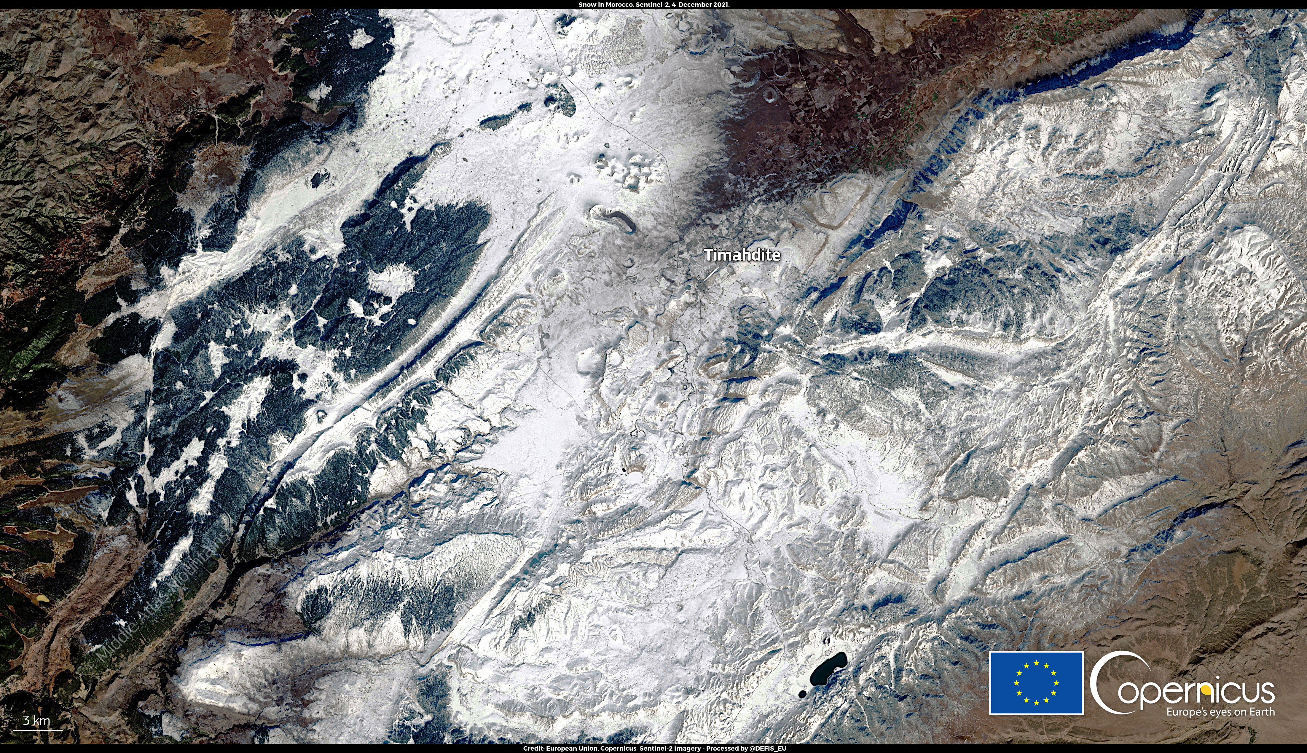
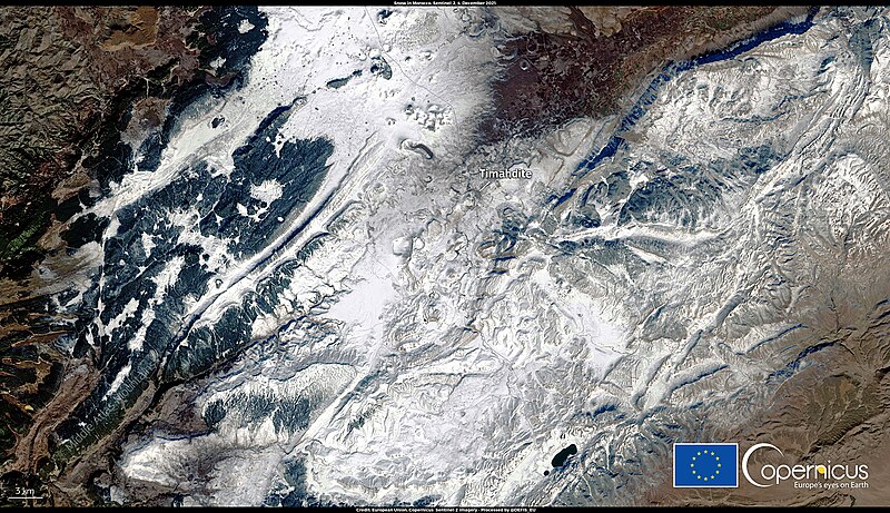
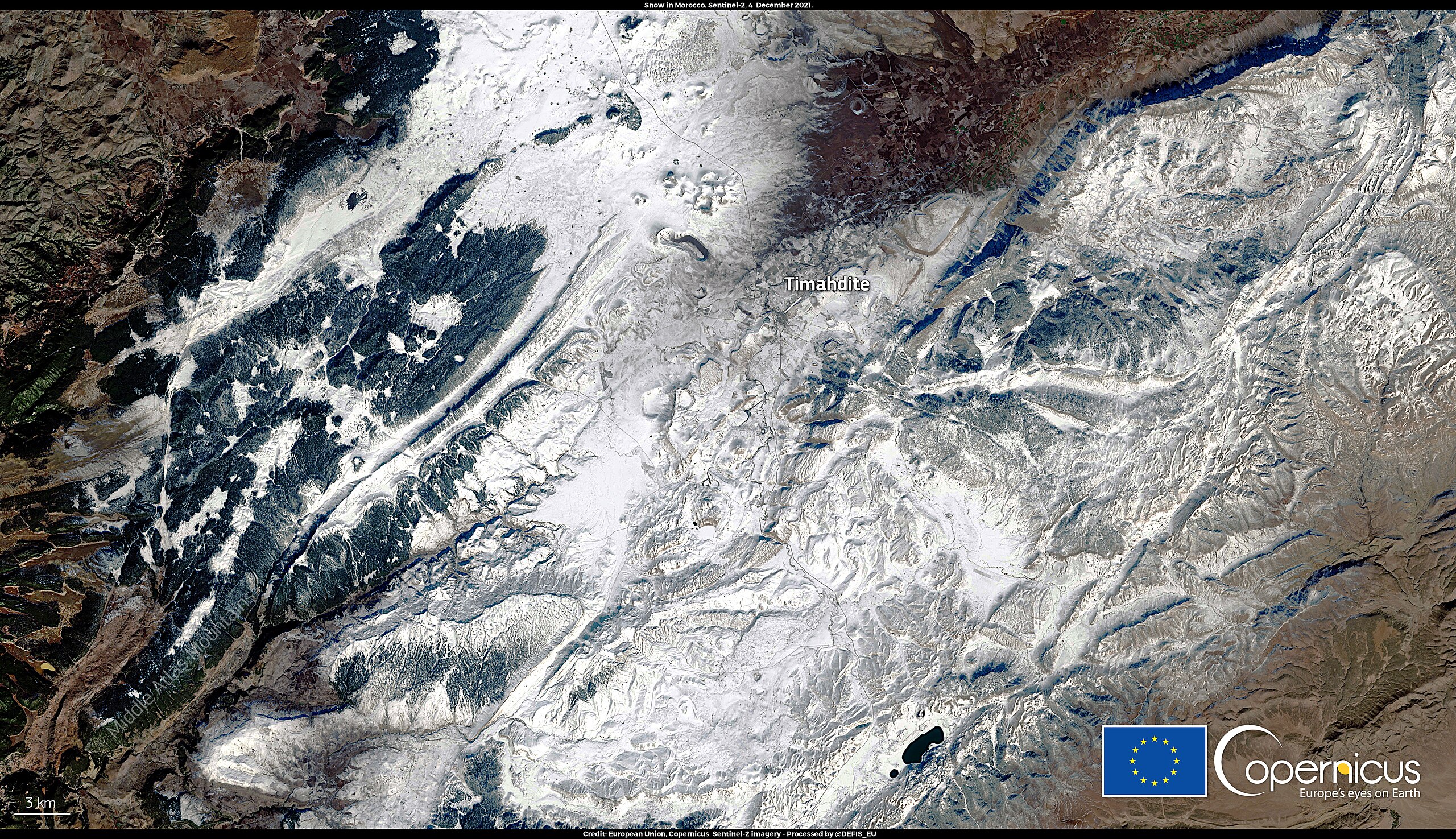
English: This image, acquired by one of the Copernicus Sentinel-2 satellites on 4 December 2021, shows the snow-covered Atlas mountains of Morocco – the highest mountain range in North Africa. It is not uncommon to observe snow-covered areas in North Africa. Snowfall can at times make roads impassable and villages can sometimes be isolated for days. This is what recently occurred in Timahdite, a Moroccan village located in the Middle Atlas mountain range in early December, following the arrival of cold air which originated in the Arctic. The data captured by the twin Copernicus Sentinel-2 satellites are particularly suitable for observing high-altitude mountain systems, mapping snow cover, and monitoring vulnerable communities around the world. |
| Date | Taken on 4 December 2021 |
| Source | Timahdite, a Moroccan mountain village trapped in snow |
| Author | European Union, Copernicus Sentinel-2 imagery |
Licensing
[edit].jpg&action=edit§ion=2)

|
This image contains data from a satellite in the Copernicus Programme, such as Sentinel-1, Sentinel-2 or Sentinel-3. Attribution is required when using this image.
Attribution: Contains modified Copernicus Sentinel data 2021
The use of Copernicus Sentinel Data is regulated under EU law (Commission Delegated Regulation (EU) No 1159/2013 and Regulation (EU) No 377/2014). Relevant excerpts:
Free access shall be given to GMES dedicated data [...] made available through GMES dissemination platforms [...].
Access to GMES dedicated data [...] shall be given for the purpose of the following use in so far as it is lawful:
GMES dedicated data [...] may be used worldwide without limitations in time.
GMES dedicated data and GMES service information are provided to users without any express or implied warranty, including as regards quality and suitability for any purpose. |
File history
Click on a date/time to view the file as it appeared at that time.
| Date/Time | Thumbnail | Dimensions | User | Comment | |
|---|---|---|---|---|---|
| current | 20:27, 3 September 2023 | | 4,408 × 2,540 (6.23 MB) | OptimusPrimeBot (talk | contribs) | #Spacemedia - Upload of https://www.copernicus.eu/system/files/2021-12/image_day/20211210_SnowMorocco.jpg via Commons:Spacemedia |
You cannot overwrite this file.
File usage on Commons
There are no pages that use this file.
.jpg&oldid=798237638)