File:Time zones of Europe.svg

Alkuperäinen tiedosto (SVG-tiedosto; oletustarkkuus 512 × 523 kuvapistettä; tiedostokoko 332 KiB)
Kuvatekstit
Kuvatekstit
Yhteenveto
| Kuvaus |
Беларуская: Карта гадзінных паясоў Еўропы
Беларуская (тарашкевіца): Мапа гадзінавых пасаў Эўропы
Čeština: Mapa časových pásem v Evropě
Dansk: Kort over Europas tidszoner
Deutsch: Karte der Zeitzonen Europas
Westeuropäische Zeit (UTC±0)
Westeuropäische Zeit (UTC±0) / Westeuropäische Sommerzeit (UTC+1)
Mitteleuropäische Zeit (UTC+1) / Mitteleuropäische Sommerzeit (UTC+2)
Kaliningrader Zeit (UTC+2)
Osteuropäische Zeit (UTC+2) / Osteuropäische Sommerzeit (UTC+3)
Moskauer Zeit / Türkei Zeit (UTC+3)
Eesti: Euroopa ajavööndite kaart
Ελληνικά: Χάρτης των χρονικών ζωνών της Ευρώπης
English: Map of the time zones of Europe
Español: Mapa de los husos horarios de Europa
Esperanto: Mapo de Eŭropo-horzonoj
Français : Carte des fuseaux horaires de l'Europe
Italiano: Mappa dei fusi orari dell'Europa
ქართული: ევროპის სასაათო ზონების რუკა
Latina: Tabula Europae tempus zonae
Latviešu: Eiropas kartē laika zonām
Lietuvių: Europos žemėlapis laiko zonų
Magyar: Európa időzónák térképe
Nederlands: Kaart van de tijdzones in Europa
Norsk bokmål: Kart over tidssoner i Europa
Polski: Mapa stref czasowych Europy
Português: Mapa dos fusos horários da Europa
Русский: Карта часовых поясов в Европе
Slovenčina: Mapa časových pásiem Európy
Slovenščina: Zemljevid časovnih pasov Evrope
Suomi: Euroopan kartta aikavyöhykkeiden
Svenska: Karta över Europas tidszoner
Українська: Мапа часових поясів Європи
日本語: ヨーロッパの時間帯の地図
中文(简体):欧洲的时区地图
中文(繁體):歐洲的時區地圖 |
| Päiväys | (UTC) |
| Lähde | Based on Blank map of Europe.svg, source: Time zones of Europe.png; |
| Tekijä | maix |
| Muut versiot |
|
| SVG kehittely | Tämä vektorigrafiikkatiedosto luotiin käyttäen apuna ohjelmaa Inkscape |


.svg)


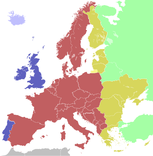
Colours
| Light blue | Western European Time / Greenwich Mean Time (UTC) |
| Blue | Western European Time / Greenwich Mean Time (UTC) Western European Summer Time (UTC+1) |
| Red | Central European Time (UTC+1) Central European Summer Time (UTC+2) |
| Yellow | Eastern European Time / Kaliningrad Time (UTC+2) |
| Golden | Eastern European Time (UTC+2) Eastern European Summer Time (UTC+3) |
| Light green | Further-eastern European Time / Moscow Time / Turkey Time (UTC+3) |
| Light colours indicate where standard time is used all year; dark colours indicate where a summer time (also known as "daylight saving time" or "DST") is used. | |
Lisenssi
Tämä teos on lisensoitu Creative Commons Tarttuva 1.0 Raakaversio (CC SA 1.0) -lisenssillä.
|

|
Tämä teos on vapaata ohjelmistoa; voit levittää ja muokata sitä Free Software Foundationin julkaiseman GNU General Public License -lisenssin version 2 tai minkä tahansa uudemman version alaisena. Tätä teosta levitetään siinä toivossa että siitä olisi hyötyä, mutta mitään takuita ei anneta, ei edes myyntikelpoisuudesta tai sopivuudesta mihinkään käyttötarkoitukseen. Lisätietoja saat GNU General Public License -lisenssin versiosta 2 ja versiosta 3. |
Tiedoston historia
Päiväystä napsauttamalla näet, millainen tiedosto oli kyseisellä hetkellä.
| Päiväys | Pienoiskuva | Koko | Käyttäjä | Kommentti | |
|---|---|---|---|---|---|
| nykyinen | 12. lokakuuta 2023 kello 13.10 | | 512 × 523 (332 KiB) | 3.kor0p (keskustelu | muokkaukset) | Reverted to version as of 23:01, 2 August 2021 (UTC). Crimea is part of Ukraine |
| 19. marraskuuta 2022 kello 01.58 |  | 593 × 606 (667 KiB) | M.Bitton (keskustelu | muokkaukset) | Reverted to version as of 13:51, 5 April 2022 (UTC): I suggest you read COM:OVERWRITE | |
| 17. marraskuuta 2022 kello 08.48 |  | 593 × 606 (666 KiB) | Рагин1987 (keskustelu | muokkaukset) | Small correction | |
| 17. marraskuuta 2022 kello 08.44 |  | 593 × 606 (666 KiB) | Рагин1987 (keskustelu | muokkaukset) | Extended map | |
| 5. huhtikuuta 2022 kello 13.51 |  | 593 × 606 (667 KiB) | Seryo93 (keskustelu | muokkaukset) | Reverted to version as of 06:42, 7 August 2021 (UTC) | |
| 27. maaliskuuta 2022 kello 10.22 |  | 512 × 523 (332 KiB) | Grudzio240 (keskustelu | muokkaukset) | Improvement of time zone in Ukraine according to maps in independent sources e.g. https://maps.lib.utexas.edu/maps/world_maps/time_zones_ref_2015.pdf or https://www.cia.gov/the-world-factbook/static/31913c20666d022fa1315bd444553f8d/world_time.pdf | |
| 7. elokuuta 2021 kello 06.42 |  | 593 × 606 (667 KiB) | Seryo93 (keskustelu | muokkaukset) | Reverted to version as of 21:12, 2 August 2021 (UTC) the longstanding consensus is for an actually observed (de facto) time | |
| 2. elokuuta 2021 kello 23.01 |  | 512 × 523 (332 KiB) | ThebeOkonma (keskustelu | muokkaukset) | Reverted to version as of 19:48, 2 August 2021 (UTC) - Correcting map error: Crimea is part of Ukraine | |
| 2. elokuuta 2021 kello 21.12 |  | 593 × 606 (667 KiB) | Ymblanter (keskustelu | muokkaukset) | Reverted to version as of 20:19, 16 April 2021 (UTC) see talk page, the user has been warned | |
| 2. elokuuta 2021 kello 19.48 |  | 512 × 523 (332 KiB) | ThebeOkonma (keskustelu | muokkaukset) | Reverted to version as of 12:52, 16 April 2021 (UTC) - Correcting map error: Crimea is part of Ukraine |
Et voi tallentaa uutta tiedostoa tämän tilalle.
Tiedoston käyttö
Seuraavat 35 sivua käyttävät tätä tiedostoa:
- Central European Time
- User:AbdealiJKTravis/logs/newimages/20160726
- User:Chumwa/OgreBot/Potential transport maps/2016 April 21-30
- User:Chumwa/OgreBot/Potential transport maps/2016 July 11-20
- User:Chumwa/OgreBot/Potential transport maps/2016 July 21-31
- User:Chumwa/OgreBot/Potential transport maps/2016 June 1-10
- User:Chumwa/OgreBot/Potential transport maps/2016 June 11-20
- User:Chumwa/OgreBot/Potential transport maps/2016 September 21-30
- User:Chumwa/OgreBot/Potential transport maps/2017 January 11-20
- User:Chumwa/OgreBot/Transport Maps/2015 August 1-10
- User:Chumwa/OgreBot/Transport Maps/2015 August 11-20
- User:Chumwa/OgreBot/Transport Maps/2015 February 10-18
- User:Chumwa/OgreBot/Transport Maps/2015 February 19-28
- User:Chumwa/OgreBot/Transport Maps/2015 October 21-31
- User:Chumwa/OgreBot/Transport Maps/2015 September 21-30
- User:Chumwa/OgreBot/Transport Maps/2016 April 21-30
- User:Chumwa/OgreBot/Transport Maps/2016 July 11-20
- User:Chumwa/OgreBot/Transport Maps/2016 July 21-31
- User:Chumwa/OgreBot/Transport Maps/2016 June 1-10
- User:Chumwa/OgreBot/Transport Maps/2016 June 11-20
- User:Chumwa/OgreBot/Transport Maps/2016 September 21-30
- User:Chumwa/OgreBot/Transport Maps/2017 January 11-20
- User:Chumwa/OgreBot/Travel and communication maps/2016 April 21-30
- User:Chumwa/OgreBot/Travel and communication maps/2016 July 11-20
- User:Chumwa/OgreBot/Travel and communication maps/2016 July 21-31
- User:Chumwa/OgreBot/Travel and communication maps/2016 June 1-10
- User:Chumwa/OgreBot/Travel and communication maps/2016 June 11-20
- User:Chumwa/OgreBot/Travel and communication maps/2016 September 21-30
- User:Chumwa/OgreBot/Travel and communication maps/2017 January 11-20
- User:OgreBot/Watercraft/2016 September 21
- File:Time zones of Europe, incl. Azores and Madeira.svg
- File:Time zones of Europe.png
- File:Time zones of Europe (Crimea disputed).svg
- File:Time zones of the Greater Europe.svg
- File:UTC hue4map X region Europe.svg
Tiedoston järjestelmänlaajuinen käyttö
Seuraavat muut wikit käyttävät tätä tiedostoa:
- Käyttö kohteessa af.wikipedia.org
- Käyttö kohteessa ar.wikipedia.org
- Käyttö kohteessa ast.wikipedia.org
- Käyttö kohteessa ba.wikipedia.org
- Käyttö kohteessa be.wikipedia.org
- Käyttö kohteessa bg.wikipedia.org
- Käyttö kohteessa bn.wikipedia.org
- ইউটিসি±০০:০০
- মধ্য ইউরোপীয় সময়
- টেমপ্লেট:ইউরোপের সময় অঞ্চল
- ইউটিসি+০১:০০
- গ্রিনিচ মান সময়
- ইউটিসি+০২:০০
- ইউটিসি+০৩:০০
- পূর্ব ইউরোপীয় সময়
- পশ্চিম ইউরোপীয় সময়
- মধ্য ইউরোপীয় গ্রীষ্মকালীন সময়
- কালিনিনগ্রাদ সময়
- মস্কো সময়
- ব্রিটিশ গ্রীষ্মকালীন সময়
- পূর্ব ইউরোপীয় গ্রীষ্মকালীন সময়
- তুরস্ক সময়
- পশ্চিম ইউরোপীয় গ্রীষ্মকালীন সময়
- Käyttö kohteessa bs.wikipedia.org
- Käyttö kohteessa ca.wikipedia.org
Näytä lisää tämän tiedoston järjestelmänlaajuista käyttöä.