File:Time zones of Europe.svg
跳至導覽
跳至搜尋

此 SVG 檔案的 PNG 預覽的大小:512 × 523 像素。 其他解析度:235 × 240 像素 | 470 × 480 像素 | 752 × 768 像素 | 1,002 × 1,024 像素 | 2,005 × 2,048 像素。
原始檔案 (SVG 檔案,表面大小:512 × 523 像素,檔案大小:332 KB)
說明
說明
添加單行說明來描述出檔案所代表的內容
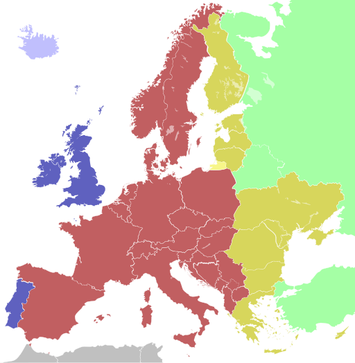
Time zones of Europe
摘要
| 描述 |
Беларуская: Карта гадзінных паясоў Еўропы
Беларуская (тарашкевіца): Мапа гадзінавых пасаў Эўропы
Čeština: Mapa časových pásem v Evropě
Dansk: Kort over Europas tidszoner
Deutsch: Karte der Zeitzonen Europas
Westeuropäische Zeit (UTC±0)
Westeuropäische Zeit (UTC±0) / Westeuropäische Sommerzeit (UTC+1)
Mitteleuropäische Zeit (UTC+1) / Mitteleuropäische Sommerzeit (UTC+2)
Kaliningrader Zeit (UTC+2)
Osteuropäische Zeit (UTC+2) / Osteuropäische Sommerzeit (UTC+3)
Moskauer Zeit / Türkei Zeit (UTC+3)
Eesti: Euroopa ajavööndite kaart
Ελληνικά: Χάρτης των χρονικών ζωνών της Ευρώπης
English: Map of the time zones of Europe
Español: Mapa de los husos horarios de Europa
Esperanto: Mapo de Eŭropo-horzonoj
Français : Carte des fuseaux horaires de l'Europe
Italiano: Mappa dei fusi orari dell'Europa
ქართული: ევროპის სასაათო ზონების რუკა
Latina: Tabula Europae tempus zonae
Latviešu: Eiropas kartē laika zonām
Lietuvių: Europos žemėlapis laiko zonų
Magyar: Európa időzónák térképe
Nederlands: Kaart van de tijdzones in Europa
Norsk bokmål: Kart over tidssoner i Europa
Polski: Mapa stref czasowych Europy
Português: Mapa dos fusos horários da Europa
Русский: Карта часовых поясов в Европе
Slovenčina: Mapa časových pásiem Európy
Slovenščina: Zemljevid časovnih pasov Evrope
Suomi: Euroopan kartta aikavyöhykkeiden
Svenska: Karta över Europas tidszoner
Українська: Мапа часових поясів Європи
日本語: ヨーロッパの時間帯の地図
中文(简体):欧洲的时区地图
中文(繁體):歐洲的時區地圖 |
| 日期 | (UTC) |
| 來源 | Based on Blank map of Europe.svg, source: Time zones of Europe.png; |
| 作者 | maix |
| 其他版本 |
|
| SVG開發 |


.svg)


Colours
| Light blue | Western European Time / Greenwich Mean Time (UTC) |
| Blue | Western European Time / Greenwich Mean Time (UTC) Western European Summer Time (UTC+1) |
| Red | Central European Time (UTC+1) Central European Summer Time (UTC+2) |
| Yellow | Eastern European Time / Kaliningrad Time (UTC+2) |
| Golden | Eastern European Time (UTC+2) Eastern European Summer Time (UTC+3) |
| Light green | Further-eastern European Time / Moscow Time / Turkey Time (UTC+3) |
| Light colours indicate where standard time is used all year; dark colours indicate where a summer time (also known as "daylight saving time" or "DST") is used. | |
授權條款

檔案歷史
點選日期/時間以檢視該時間的檔案版本。
| 日期/時間 | 縮圖 | 尺寸 | 用戶 | 備註 | |
|---|---|---|---|---|---|
| 目前 | 2023年10月12日 (四) 13:10 | | 512 × 523(332 KB) | 3.kor0p(對話 | 貢獻) | Reverted to version as of 23:01, 2 August 2021 (UTC). Crimea is part of Ukraine |
| 2022年11月19日 (六) 01:58 |  | 593 × 606(667 KB) | M.Bitton(對話 | 貢獻) | Reverted to version as of 13:51, 5 April 2022 (UTC): I suggest you read COM:OVERWRITE | |
| 2022年11月17日 (四) 08:48 |  | 593 × 606(666 KB) | Рагин1987(對話 | 貢獻) | Small correction | |
| 2022年11月17日 (四) 08:44 |  | 593 × 606(666 KB) | Рагин1987(對話 | 貢獻) | Extended map | |
| 2022年4月5日 (二) 13:51 |  | 593 × 606(667 KB) | Seryo93(對話 | 貢獻) | Reverted to version as of 06:42, 7 August 2021 (UTC) | |
| 2022年3月27日 (日) 10:22 |  | 512 × 523(332 KB) | Grudzio240(對話 | 貢獻) | Improvement of time zone in Ukraine according to maps in independent sources e.g. https://maps.lib.utexas.edu/maps/world_maps/time_zones_ref_2015.pdf or https://www.cia.gov/the-world-factbook/static/31913c20666d022fa1315bd444553f8d/world_time.pdf | |
| 2021年8月7日 (六) 06:42 |  | 593 × 606(667 KB) | Seryo93(對話 | 貢獻) | Reverted to version as of 21:12, 2 August 2021 (UTC) the longstanding consensus is for an actually observed (de facto) time | |
| 2021年8月2日 (一) 23:01 |  | 512 × 523(332 KB) | ThebeOkonma(對話 | 貢獻) | Reverted to version as of 19:48, 2 August 2021 (UTC) - Correcting map error: Crimea is part of Ukraine | |
| 2021年8月2日 (一) 21:12 |  | 593 × 606(667 KB) | Ymblanter(對話 | 貢獻) | Reverted to version as of 20:19, 16 April 2021 (UTC) see talk page, the user has been warned | |
| 2021年8月2日 (一) 19:48 |  | 512 × 523(332 KB) | ThebeOkonma(對話 | 貢獻) | Reverted to version as of 12:52, 16 April 2021 (UTC) - Correcting map error: Crimea is part of Ukraine |
無法覆蓋此檔案。
檔案用途
下列35個頁面有用到此檔案:
- Central European Time
- User:AbdealiJKTravis/logs/newimages/20160726
- User:Chumwa/OgreBot/Potential transport maps/2016 April 21-30
- User:Chumwa/OgreBot/Potential transport maps/2016 July 11-20
- User:Chumwa/OgreBot/Potential transport maps/2016 July 21-31
- User:Chumwa/OgreBot/Potential transport maps/2016 June 1-10
- User:Chumwa/OgreBot/Potential transport maps/2016 June 11-20
- User:Chumwa/OgreBot/Potential transport maps/2016 September 21-30
- User:Chumwa/OgreBot/Potential transport maps/2017 January 11-20
- User:Chumwa/OgreBot/Transport Maps/2015 August 1-10
- User:Chumwa/OgreBot/Transport Maps/2015 August 11-20
- User:Chumwa/OgreBot/Transport Maps/2015 February 10-18
- User:Chumwa/OgreBot/Transport Maps/2015 February 19-28
- User:Chumwa/OgreBot/Transport Maps/2015 October 21-31
- User:Chumwa/OgreBot/Transport Maps/2015 September 21-30
- User:Chumwa/OgreBot/Transport Maps/2016 April 21-30
- User:Chumwa/OgreBot/Transport Maps/2016 July 11-20
- User:Chumwa/OgreBot/Transport Maps/2016 July 21-31
- User:Chumwa/OgreBot/Transport Maps/2016 June 1-10
- User:Chumwa/OgreBot/Transport Maps/2016 June 11-20
- User:Chumwa/OgreBot/Transport Maps/2016 September 21-30
- User:Chumwa/OgreBot/Transport Maps/2017 January 11-20
- User:Chumwa/OgreBot/Travel and communication maps/2016 April 21-30
- User:Chumwa/OgreBot/Travel and communication maps/2016 July 11-20
- User:Chumwa/OgreBot/Travel and communication maps/2016 July 21-31
- User:Chumwa/OgreBot/Travel and communication maps/2016 June 1-10
- User:Chumwa/OgreBot/Travel and communication maps/2016 June 11-20
- User:Chumwa/OgreBot/Travel and communication maps/2016 September 21-30
- User:Chumwa/OgreBot/Travel and communication maps/2017 January 11-20
- User:OgreBot/Watercraft/2016 September 21
- File:Time zones of Europe, incl. Azores and Madeira.svg
- File:Time zones of Europe.png
- File:Time zones of Europe (Crimea disputed).svg
- File:Time zones of the Greater Europe.svg
- File:UTC hue4map X region Europe.svg
全域檔案使用狀況
以下其他 wiki 使用了這個檔案:
- af.wikipedia.org 的使用狀況
- ar.wikipedia.org 的使用狀況
- ast.wikipedia.org 的使用狀況
- ba.wikipedia.org 的使用狀況
- be.wikipedia.org 的使用狀況
- bg.wikipedia.org 的使用狀況
- bn.wikipedia.org 的使用狀況
- ইউটিসি±০০:০০
- মধ্য ইউরোপীয় সময়
- টেমপ্লেট:ইউরোপের সময় অঞ্চল
- ইউটিসি+০১:০০
- গ্রিনিচ মান সময়
- ইউটিসি+০২:০০
- ইউটিসি+০৩:০০
- পূর্ব ইউরোপীয় সময়
- পশ্চিম ইউরোপীয় সময়
- মধ্য ইউরোপীয় গ্রীষ্মকালীন সময়
- কালিনিনগ্রাদ সময়
- মস্কো সময়
- ব্রিটিশ গ্রীষ্মকালীন সময়
- পূর্ব ইউরোপীয় গ্রীষ্মকালীন সময়
- তুরস্ক সময়
- পশ্চিম ইউরোপীয় গ্রীষ্মকালীন সময়
- bs.wikipedia.org 的使用狀況
- ca.wikipedia.org 的使用狀況
檢視此檔案的更多全域使用狀況。