File:Time zones of Europe (Crimea disputed).svg
ナビゲーションに移動
検索に移動

この SVG ファイルのこの PNG プレビューのサイズ: 587 × 600 ピクセル. その他の解像度: 235 × 240 ピクセル | 470 × 480 ピクセル | 752 × 768 ピクセル | 1,002 × 1,024 ピクセル | 2,004 × 2,048 ピクセル | 593 × 606 ピクセル。
元のファイル (SVG ファイル、593 × 606 ピクセル、ファイルサイズ: 667キロバイト)
キャプション
キャプション
このファイルの内容を1行で記述してください
概要[編集]
| 解説 |
Беларуская: Карта гадзінных паясоў Еўропы
Беларуская (тарашкевіца): Мапа гадзінавых пасаў Эўропы
Čeština: Mapa časových pásem v Evropě
Ελληνικά: Χάρτης των χρονικών ζωνών της Ευρώπης
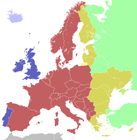
English: Map of the time zones of Europe, with Crimea disputed
Eesti: Euroopa ajavööndite kaart
Suomi: Euroopan kartta aikavyöhykkeiden
Українська: Мапа часових поясів Європи
Lietuvių: Europos žemėlapis laiko zonų
Latviešu: Eiropas kartē laika zonām
Русский: Карта часовых поясов в Европе
Slovenščina: Mapa časových pásiem v Európe
Svenska: Karta över Europas tidszoner, dock är den i Krim omtvistad |
| 日付 | |
| 原典 |
Derived from: |
| 作者 | Rob984 |
| その他のバージョン |
|


.svg&action=edit§ion=1)
Colours[編集]
.svg&action=edit§ion=2)
| Light blue | Western European Time / Greenwich Mean Time (UTC) |
| Blue | Western European Time / Greenwich Mean Time (UTC) Western European Summer Time (UTC+1) |
| Red | Central European Time (UTC+1) Central European Summer Time (UTC+2) |
| Yellow | Eastern European Time / Kaliningrad Time (UTC+2) |
| Golden | Eastern European Time (UTC+2) Eastern European Summer Time (UTC+3) |
| Light green | Further-eastern European Time / Moscow Time / Turkey Time (UTC+3) |
| Light colours indicate where standard time is observed all year; dark colours indicate where a summer time (also known as "daylight saving time" or "DST") is observed. | |
ライセンス[編集]
.svg&action=edit§ion=3)
この作品の著作権者である私は、この作品を以下のライセンスで提供します。
このファイルはクリエイティブ・コモンズ 表示-継承 4.0 国際ライセンスのもとに利用を許諾されています。
- あなたは以下の条件に従う場合に限り、自由に
- 共有 – 本作品を複製、頒布、展示、実演できます。
- 再構成 – 二次的著作物を作成できます。
- あなたの従うべき条件は以下の通りです。
- 表示 – あなたは適切なクレジットを表示し、ライセンスへのリンクを提供し、変更があったらその旨を示さなければなりません。これらは合理的であればどのような方法で行っても構いませんが、許諾者があなたやあなたの利用行為を支持していると示唆するような方法は除きます。
- 継承 – もしあなたがこの作品をリミックスしたり、改変したり、加工した場合には、あなたはあなたの貢献部分を元の作品とこれと同一または互換性があるライセンスの下に頒布しなければなりません。
ファイルの履歴
過去の版のファイルを表示するには、その版の日時をクリックしてください。
| 日付と時刻 | サムネイル | 寸法 | 利用者 | コメント | |
|---|---|---|---|---|---|
| 現在の版 | 2018年1月16日 (火) 21:13 | | 593 × 606 (667キロバイト) | Maphobbyist (トーク | 投稿記録) | Reverted to version as of 21:12, 16 January 2018 (UTC) |
| 2018年1月16日 (火) 21:13 |  | 593 × 606 (667キロバイト) | Maphobbyist (トーク | 投稿記録) | Reverted to version as of 11:47, 26 July 2016 (UTC) | |
| 2018年1月16日 (火) 21:12 |  | 593 × 606 (667キロバイト) | Maphobbyist (トーク | 投稿記録) | Reverted to version as of 22:49, 8 September 2016 (UTC) | |
| 2016年9月21日 (水) 04:31 |  | 593 × 606 (667キロバイト) | AKS471883 (トーク | 投稿記録) | Northern Cyprus+ | |
| 2016年9月8日 (木) 22:49 |  | 593 × 606 (667キロバイト) | Rob984 (トーク | 投稿記録) | Turkey has Changed to UTC+3 all year round | |
| 2016年7月26日 (火) 11:47 |  | 593 × 606 (667キロバイト) | Rob984 (トーク | 投稿記録) | User created page with UploadWizard |
このファイルは上書きできません。
ファイルの使用状況
以下の 13 ページがこのファイルを使用しています:
- User:Chumwa/OgreBot/Potential transport maps/2016 July 21-31
- User:Chumwa/OgreBot/Potential transport maps/2016 September 1-10
- User:Chumwa/OgreBot/Potential transport maps/2016 September 21-30
- User:Chumwa/OgreBot/Transport Maps/2016 July 21-31
- User:Chumwa/OgreBot/Transport Maps/2016 September 1-10
- User:Chumwa/OgreBot/Transport Maps/2016 September 21-30
- User:Chumwa/OgreBot/Travel and communication maps/2016 July 21-31
- User:Chumwa/OgreBot/Travel and communication maps/2016 September 1-10
- User:Chumwa/OgreBot/Travel and communication maps/2016 September 21-30
- File:Countries of Europe (Crimea disputed).svg (リダイレクト)
- File:Time zones of Europe, incl. Azores and Madeira.svg
- File:Time zones of Europe.svg
- File:Time zones of the Greater Europe.svg
.svg&redirect=no)
グローバルなファイル使用状況
以下に挙げる他のウィキがこの画像を使っています:
- en.wikipedia.org での使用状況
- nl.wikipedia.org での使用状況
- simple.wikipedia.org での使用状況
- th.wikipedia.org での使用状況
- uz.wikipedia.org での使用状況
- zh-yue.wikipedia.org での使用状況
.svg&oldid=758432246)