File:Timna Eilat 4.04.2021.jpg
Original file (4,032 × 1,816 pixels, file size: 3.35 MB, MIME type: image/jpeg)
Captions
Summary
[edit]DescriptionTimna Eilat 4.04.2021.jpg |
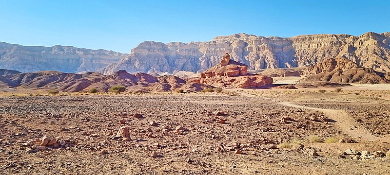
עברית: בקעת תִּמְנָע היא בקעה בשוליים המערביים של הערבה הדרומית, כ-25 קילומטר מצפון לאילת. הבקעה, שלהּ צורת פרסה, משתרעת על פני שטח של כ-60 קילומטר רבוע, ותחומה במצוקים תלולים משלושת צדדיה. היא מנוקזת על ידי נחל תמנע בצפון ונחל נחושתן בדרום, הזורמים לערבה שממזרח לה. במרכזהּ מתרומם הר תמנע לגובה של 453 מטרים. באזור שורר אקלים מדברי קיצוני. האדם נמשך לבקעת תמנע החל בתקופה הנאוליתית, בערך 10,000 לפנה"ס ואילך, בשל עפרות הנחושת המצויות בה.
|
||
Date | |||
Source | Own work | ||
Author | Yulia Eilat |
Camera location | 29° 47′ 09.29″ N, 34° 57′ 53.38″ E | View this and other nearby images on: OpenStreetMap | 29.785915; 34.964828 |
---|
Licensing
[edit]- You are free:
- to share – to copy, distribute and transmit the work
- to remix – to adapt the work
- Under the following conditions:
- attribution – You must give appropriate credit, provide a link to the license, and indicate if changes were made. You may do so in any reasonable manner, but not in any way that suggests the licensor endorses you or your use.
- share alike – If you remix, transform, or build upon the material, you must distribute your contributions under the same or compatible license as the original.
This image was uploaded as part of Wiki Loves Monuments 2021.
Afrikaans ∙ Alemannisch ∙ azərbaycanca ∙ Bahasa Indonesia ∙ Bahasa Melayu ∙ Bikol Central ∙ bosanski ∙ brezhoneg ∙ català ∙ čeština ∙ Cymraeg ∙ dansk ∙ davvisámegiella ∙ Deutsch ∙ eesti ∙ English ∙ español ∙ Esperanto ∙ euskara ∙ français ∙ Frysk ∙ Gaeilge ∙ galego ∙ hrvatski ∙ Ido ∙ italiano ∙ latviešu ∙ Lëtzebuergesch ∙ Malagasy ∙ magyar ∙ Malti ∙ Nederlands ∙ norsk ∙ norsk nynorsk ∙ norsk bokmål ∙ polski ∙ português ∙ português do Brasil ∙ română ∙ shqip ∙ sicilianu ∙ slovenčina ∙ slovenščina ∙ suomi ∙ svenska ∙ Tagalog ∙ Türkçe ∙ Yorùbá ∙ Zazaki ∙ Ελληνικά ∙ беларуская ∙ беларуская (тарашкевіца) ∙ български ∙ кыргызча ∙ македонски ∙ русский ∙ српски / srpski ∙ українська ∙ ქართული ∙ հայերեն ∙ नेपाली ∙ हिन्दी ∙ বাংলা ∙ മലയാളം ∙ ไทย ∙ 한국어 ∙ +/− |
File history
Click on a date/time to view the file as it appeared at that time.
Date/Time | Thumbnail | Dimensions | User | Comment | |
---|---|---|---|---|---|
current | 14:19, 28 September 2021 | 4,032 × 1,816 (3.35 MB) | Yulia Eilat (talk | contribs) | Uploaded own work with UploadWizard |
You cannot overwrite this file.
File usage on Commons
The following page uses this file:
Metadata
This file contains additional information such as Exif metadata which may have been added by the digital camera, scanner, or software program used to create or digitize it. If the file has been modified from its original state, some details such as the timestamp may not fully reflect those of the original file. The timestamp is only as accurate as the clock in the camera, and it may be completely wrong.
Camera manufacturer | samsung |
---|---|
Camera model | SM-G996B |
Exposure time | 1/2,536 sec (0.00039432176656151) |
F-number | f/1.8 |
ISO speed rating | 50 |
Date and time of data generation | 16:47, 3 April 2021 |
Lens focal length | 5.4 mm |
Latitude | 29° 47′ 9.29″ N |
Longitude | 34° 57′ 53.38″ E |
Width | 4,032 px |
Height | 1,816 px |
Bits per component |
|
Pixel composition | RGB |
Orientation | Normal |
Number of components | 3 |
Horizontal resolution | 72 dpi |
Vertical resolution | 72 dpi |
Software used | Adobe Photoshop CC (Windows) |
File change date and time | 16:57, 28 September 2021 |
Y and C positioning | Centered |
Exposure Program | Normal program |
Exif version | 2.2 |
Date and time of digitizing | 16:47, 3 April 2021 |
APEX shutter speed | 0.00039432176656151 |
APEX aperture | 1.69 |
APEX brightness | 22.95 |
APEX exposure bias | 0 |
Maximum land aperture | 1.69 APEX (f/1.8) |
Metering mode | Center weighted average |
Flash | Flash did not fire |
Color space | sRGB |
Exposure mode | Auto exposure |
White balance | Auto white balance |
Digital zoom ratio | 1 |
Focal length in 35 mm film | 26 mm |
Scene capture type | Standard |
Unique image ID | R12LLMF05VM |
Date metadata was last modified | 19:57, 28 September 2021 |
Unique ID of original document | 314D90AB1F0B76FA4A48DEE165554ED8 |
Structured data
Items portrayed in this file
depicts
some value
29°47'9.294"N, 34°57'53.381"E
0.00039432176656151419 second
1.8
5.4 millimetre
- Heritage sites in Israel with known IDs
- CC-BY-SA-4.0
- Self-published work
- Images from Wiki Loves Monuments 2021
- Images from Wiki Loves Monuments 2021 in Israel
- Images from Wiki Loves Monuments missing SDC inception
- Uploaded via Campaign:wlm-il
- Taken with Samsung Galaxy S21+ 5G
- Israel photographs taken on 2021-04-03